Helo N231AA lifted from Truckee Airport ~~ 5 minutes ago. Dispatch was scratchy but appears headed to the Oak (per Flightradar24)
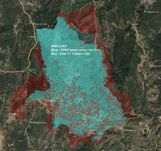
FIRIS from (I think, someone correct me if not) 0530 this morning in blue. Intel 17 flew and produced the map in red at 1106am. Gives a rough idea of progression this morning.
The Central Sierra Fire Tactical Feed is updated
AA requesting additional 3 LATS to the incident. Spotting over the direct line construction, Div R and M.
Added a new division, didn’t catch the letter or location.
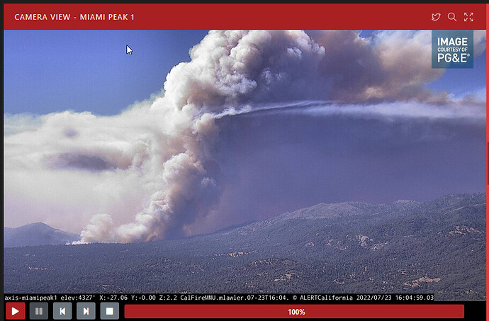
The fire is 9,500 acres and probably a bit bigger, or will be soon enough. AA is still dealing with long range spotting across the line. 10 structures reported as destroyed with unknown number damaged. 2,200 structures threatened, and about 3,000 without power. The aircraft seem to be working around Jerseydale and specifically around Pinecrest Ln. The fire has a large Cap on it now, so we may see plume dominated fire behavior if not occurring already.
EDIT, The fire has also crossed Jerseydale road near Wild Dove Ln, they were hoping to hold in the shorter grass, but that did not hold.
7/23 ops map link
Div M reporting battling winds and predicting more erratic fire behavior within next few hours.
Edit: And anticipating more spots across line.
Traffic Div R: Although an Alpha ST picked up spots on north end of Jerseydale, Div R reporting lower Jerseydale Rd completely compromised. They are forming a plan to prep the ridgeline to the east of Jerseydale Rd.
Edit: Div M and Brach Five similar traffic. Confirming lower Jerseydale Rd at Triangle compromised. All non pertinent fire traffic not to go through.
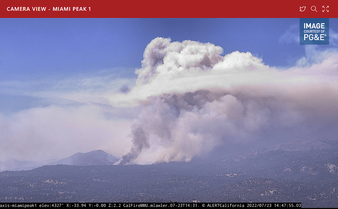
Looking at the view field of the camera, I’d say the large (and growing) column just to the left of center is where they’re having the problem. Tankers were dropping on it a bit earlier - not sure if they’re still working it or not.
11500 acres per AA (per mapping flight)
Listening to the tankers dropping on the old dozer line from 2018 Ferguson Fire and dozers starting up the bottom opening up the old control line alongside the drops. Hoping the dozers don’t push down the fuels that the tankers covered. Can they get put it in before the fire gets to it?? Then can it get support??
Fire is angry… per Lead.
Added to aircraft rotation is 1 VLAT, and 4 more LATs
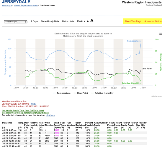
RAWS Jersydale is probably shaded:
3 PM
Avg. winds 7.0
Gusts 18.0
Winds out of 11 degrees
Air temp.86.0
Fuel temp 89.0
10 fuel stick 4.5% (critically low)
RH 14
Airattack reports now @ 11,800 ac
Forecast:
Spot Forecast for OAK…CALFIRE
National Weather Service Hanford CA
242 PM PDT Sat Jul 23 2022
Forecast is based on forecast start time of 1900 PDT on July 23.
If conditions become unrepresentative…contact the National Weather
Service.
.DISCUSSION…
Hot and dry conditions will persist during the period with
afternoon breezy conditions. Return of afternoon and evening
thunderstorms across the Sierra starting on Thursday and
continuing through next weekend.
.REST OF TONIGHT…
Sky/weather…Mostly cloudy then becoming partly cloudy.
Areas of smoke.
Min temperature…63-68.
Max humidity…20-25 percent.
Eye level winds…North winds up to 4 mph in the evening shifting
to the east up to 3 mph overnight.
Surrounding ridge…North winds up to 5 mph.
Mixing height…lowering to around 100 ft AGL after 2100 PDT.
Transport winds…Northeast around 5 mph.
.SUNDAY…
Sky/weather…Mostly sunny. Areas of smoke.
Max temperature…91-96.
Min humidity…10-15 percent.
Eye level winds…South winds up to 5 mph in the morning shifting
to the southwest in the afternoon.
Surrounding ridge…Southwest winds up to 5 mph.
Mixing height…Rising to around 6100 ft AGL after 0800 PDT.
Transport winds…Southwest around 4 mph.
.SUNDAY NIGHT…
Sky/weather…Mostly cloudy. Areas of smoke.
Min temperature…64-69.
Max humidity…25-30 percent.
Eye level winds…North winds up to 5 mph in the evening shifting
to the northeast overnight.
Surrounding ridge…Northeast winds up to 5 mph.
Mixing height…lowering to around 100 ft AGL after 2100 PDT.
Transport winds…Northeast around 5 mph.
$$
Forecaster…BARLOW
Requested by…Troy Velin
Type of request…WILDFIRE
.TAG 2215573.1/HNX
.DELDT 07/23/22
.FormatterVersion 1.0.26
OES 2801A being dispatched from Monterey County
#OakFire off Hwy 140 and Carstens Rd, near Midpines, in Mariposa County is 11,900 acres. In Unified Command: CAL FIRE Madera-Mariposa-Merced and Sierra National Forest.
Link to the daily products- Maps, IAPs, etc


