CA-MNF-August Complex???

Separate from supporting the firing ops plan on the north complex, another asm and lead plane pair worked some LAT’s and VLAT in the southwest armpit of this thing, which is well north of Covelo and still in the wilderness. Not sure if they were supporting ground work, or if they were simply painting from “Hopkins black” to “Hennessy black” while they had an opportunity with clear skies. This piece will be aligned with tomorrow evening’s winds, and is in some wild land. Didn’t get a chance to check the Ops map and see if any dozers were close in there or working indirect outside the wilderness.

Considering they had VLAT support on this remote piece this afternoon, someone’s foreseeing the ramifications if this blows out tomorrow night.

6 Likes

With tonight’s NE winds coming and yesterday’s “middle of nowhere” tanker drops, I decided to dig a bit deeper this morning on the West Zone and what this side looks like inside the fire’s dog leg. It’s hard to comprehend the scale of this when I was flying around in Google Earth because the “small picture” I envisioned is really a big picture. I decided to set the map up to be a reference for what could be a major battle ground for the West Zone during this upcoming wind event.

Google Earth looking NE (upwind tonight), with last night’s IR perimeter 9/25 2200 (with clouds obscuring some of that Branch 9 area so perimeter approx location), this morning’s Ops map features and points of reference, and white lines are completed dozer lines extracted from 9/26 incident data. Covelo is just off the bottom of map, Anthony Peak on right edge. Turquoise county lines. DIV and BRANCH break is DP67. Yesterday’s tanker drops were around Big Butte area in Branch 9.

I have no narration or intel on this side, so all I’ll say is there’s a lot of aligned unburnt land between fire edge and the first dozer line. Dozer lines are all on SRA and as close to FRA and Wilderness as they can get.

For scale, the primary dozer line starting at DP60 is 17 miles long to the black in Branch 9.

Weather representing this area

  • IRAWS 31 Russel Ridge 3052ft, (just off the left side of map, due left of DP71)
  • IRAWS 14 Soldier Ridge 5559ft (on my map, due up and little right from DP67, in the black, north of county line)
  • RAWS MNF Portable 04, Indian Dick Fire Station just below IRAWS14, 1450ft.
15 Likes

Great info, thanks!

North Zone doing some firing ops now along Hwy36 and Forest Glen area, and AA just ordered up 2 VLAT and 4 LAT to support the firing ops. There is a window of visibility before smoke to the north potentially cuts off their aerial opportunities.

They have three Firebosses up there working just east of the firing ops. 2-3 heavy rotor working the inside dogleg in Branch 9 mentioned above. Mobile Retardant Bases setup just outside of Hayfork and in Covelo. Two bucket ships on standby at Wildwood as well.

Scancal.org/live.html live scanner has the North and South command, as well as higher elevation aircraft.

1700 Update:
Helitorch operations south of Hwy36 happening (“ping pong ops”) and LAT/VLAT continues painting along the Hwy36 corridor. A couple LAT and VLAT placed on hold at KMCC but T944 confirmed load and return. T944 and the last few LAT drops will complete the retardant mission for the day, strong work! ALL aircraft ops shuts down over the incident about 1830 tonight to give rotor and fixed wing time to RTB with visibility etc. So they’re working this window of time hard. Rattlesnake MRB is setup with 6000gal mixed and ready, and 2 tenders will do the best they can to keep up. Not sure where this is located, along Rattlesnake Creek (Forest Glen area, or if this is the Hayfork MRB).

The incoming WX is a huge blessing for this north side and Post Mountain community. Between today’s firing and retardant, and tonights winds, everything should be in favor of putting this north end to sleep once and for &$F@! all. They’re also working the western flank of this bit from Forest Glen to DP117 hard to make sure this doesn’t skirt around with the winds and back into Ruth.

Here is snapshot of the OPS map of this piece to orient yourself with North Zone CMD radio traffic and aircraft ops.

I was up at Pickett Peak mid August and took these pics. This first one is DP116 looking back north “up” Southfork Ridge. Burn scar is from 2015 Mad River Complex.

This is a panorama of the eastern view from the old Pickett Peak lookout, overlooking the South Fork Trinity and Rattlesnake Creek drainages, where this whole firing ops is happening.

This is about a 180deg panorama from the cell tower at Pickett Peak looking south down Southfork Ridge to Horse Ridge. Ruth and the Mad River basin slight right of center, Van Duzen basin far right, South Fork Trinity and North Yolla Bolla to the left.

14 Likes

10am Sunday: Aircraft overhead the north and west complex experiencing 40+ kts which will severly impact aircraft ops.

The inside dogleg (West, Branch 9, Div Y) mentioned a few posts up just woke up angry. Soldier Ridge IRAWS showing single digit RH, NE 10G26.

GOES17 Fire imagery

Patton Hill one and two have the smoke laid down, but nothing defined yet. One of the Satterlee cams should have had this also, but has an oak tree in the way in that direction, and is pointing too far down.

1012: Getting word the fire is out of the line and running. (update, still inside the SRA line I think. It is still east of the north fork of middle fork of Eel River. If it crosses that, it may trigger some extensive action and firing ops on Y.)

1 Like

Anyone got a report on condition from the North Zone ? Big plume, laid over. Did FS proceed with burning yesterday ?

See above link from @norcalscan. Put the loop in motion, and you will see the root of the activity.

Looks like corral dip,Travis ranch,brush Mountain area


10:45 north zone now showing

1 Like

Yes burned all night and continuing to burn in DIV M. Large plume building. They have spots over the direct line but are saying it’s all inside the secondary line… for now

2 Likes

Satellite loop showing lots of smoke production in the “dog leg”: https://col.st/amPBA

2 Likes

1330: 75acre spot in West DIV Y coming out of the dog leg, onto SRA just south of Brush Mtn and east of Russel Ridge.

1350: slopping over the dozer line in Forest Glen (North DIV I.) Starting to take a defensive posture on that area before Div E becomes impacted.

7 Likes

Does anyone have a photo of a complete operations map ?

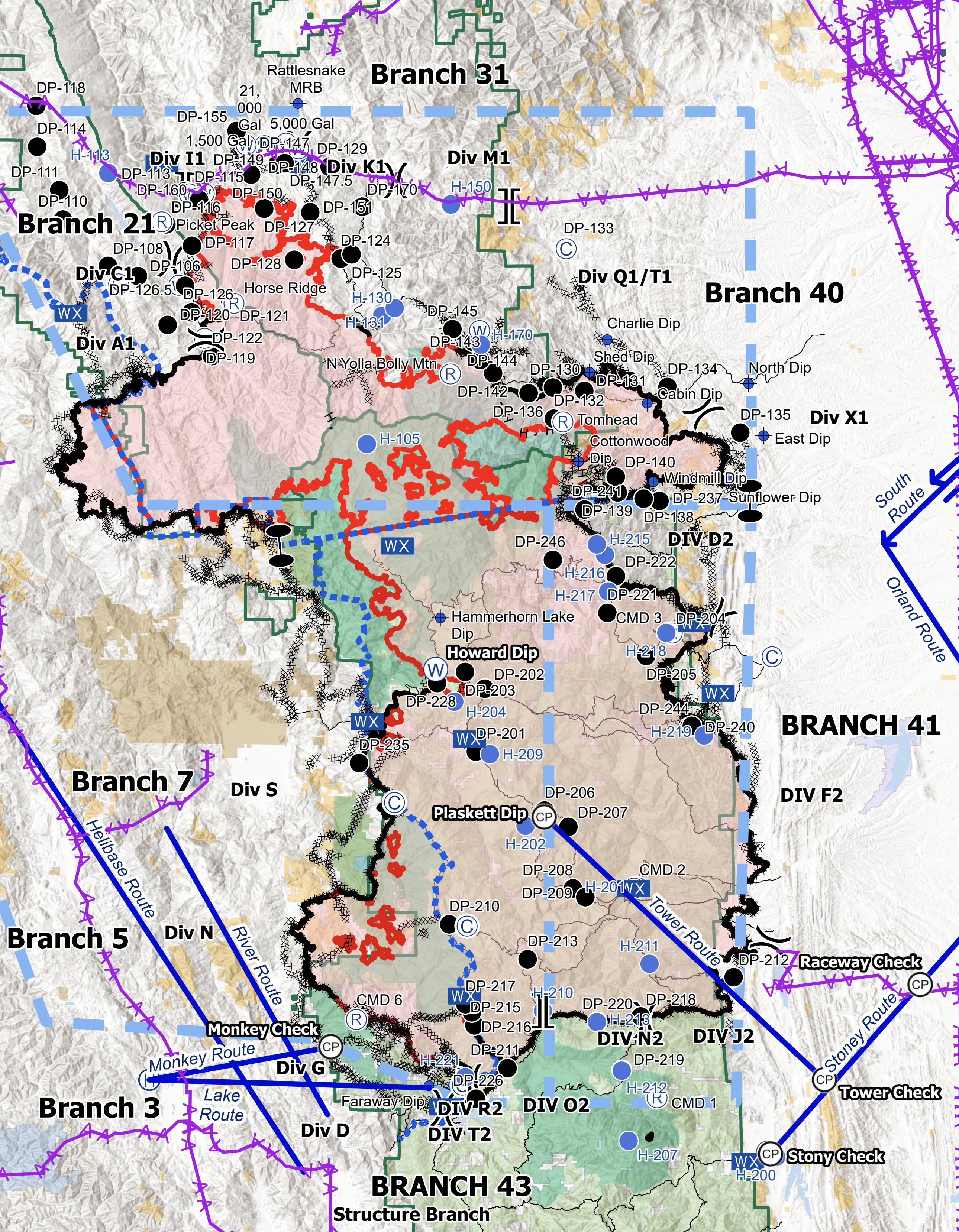
All 68 by 48 miles of the fire, without breaking the forum image size and still be useful? haha.

Today’s South Zone products
Today’s North Zone products
Today’s West Zone products

Air Summary is good for a quick overview of Branch and DIV of the South and North Zones.

6 Likes

Here’s the 10/5 summary for this beast. I might get some of this wrong, but let’s see how it turns out.

MNF-August Complex
1,002,097 acres, 54% contained

  • South Zone - Pacific NW Team 2 (was Great Basin Team 1), transitioning 10/7 to new IMT

  • Northeast Zone - Alaska Team 1 (and a quickly growing relationship with neighboring CalFire IMT2 on the SHU-Zogg I think for CalFire input around SRA and Wildwood, Platina area.)

  • Coast Range Area Command

    • Northwest Zone - Pacific NW Team 2 (transitioned Sunday) from Alaska Team 1
    • West Zone - CalFire IMT 5

I’m only seeing a couple references to the Area Command so for sake of ICS fun, threw it in there, but it’s a 4 zone fire. Calfire West Zone is definitely coming in pretty far into NW Zone to assist with some slops and direct attack etc.

Below is a PIO map from today on the inciweb site, however the zone lines weren’t all there so I edited in the lines in salmon dashed lines in their rough location.

6 Likes

43 Branches…

1 Like

10/9 Complex Summary
1,021,476 acres, 65% contained
Inciweb has a decent and updated narrative

Coast Range Area Command

  • South Zone - Southwest Team 1
  • Northeast Zone - Great Basin Team 2 (with informal assist from CalFire IMT2 on SHU-Zogg I think for the SRA areas in and around Wildwood and Platina)
  • Northwest Zone - Pacific Northwest Team 1
  • West Zone - CalFire IMT 5

(opinion)
Definitely a different feel on all three fed zones with these latest team switches. Getting a lot of frustrated intel coming off the line, it appears both NE/NW zones forgot about Covid, among other things. Long meal lines and handrails have returned to camp replacing the Alaska Team’s covid rap and daily kindergarten lesson at morning briefing. Word of drinking water shortages this morning, etc. Southwest Team’s IAP front page has a great covid message with their Leader’s intent, while PNW’s IAP front page reminds everyone of the new federal fiscal year. Shrug, you win some you lose some. Stay safe out there!

Incoming cold front has the anticipated rain down to .10" or less, if any, and scattered over the northern pieces of the complex Saturday afternoon. Winds will be picking up WSW as the front comes in, which is aligned with some open fire on the NW zone near Little Bear Wallow, and the NE zone in the volatile E-W aligned Beegum Creek drainage, which could make a very large run if conditions allow.

Red Bluff helibase pretty much shutdown yesterday, NE rotor out of Weaverville now. NW rotor have been working out of Kneeland, W rotor out of Garberville and S rotor out of Willits.

12 Likes

Hopefully this will keep up for a bit…

12 Likes

The Forest Service has issued a finalized map shows how severed the terrain has burned inside the perimeter of the South Zone of the August Complex, the largest fire in California history.

The map data is used by the Burned Area Emergency Response (BAER) team to identify areas of concern for soil erosion, accelerated surface water run-off, and debris flows that could impact human life and safety and to protect property and critical natural and cultural resources.

The map shows that over half of the 521,256 acres that are mapped out are either unburned, or have not had very much burn. 9% is considered “unburned or very low” and 43% has “low” soil burn severity.

https://inciweb.nwcg.gov/incident/7228/

Hopefully I have not put this in the wrong thread. I long ago lost track of it all. :blush: :stuck_out_tongue_winking_eye:

4 Likes

Picking up rising smoke on two different cameras . Looks like it is south of Ruth Lake . winds in the area are gusting to 24.


image

4 Likes

Thx for your updates!

1 Like

Trinity SO starting evacuations

10/15/20 UPDATE August Complex

Per the Trinity County Sheriff’s Office and the Office of Emergency Services, the following areas are under an Evacuation Order. Areas North of the Kettenpom store, up to the area of Bluff Creek and East of the Zenia Lake Mountain Road, should be evacuated at this time. There is an immediate threat to life in these areas due to increased fire activity. This is a lawful order please leave now. These areas are now closed to public access. Please take caution and drive carefully as emergency vehicles will be on the roads in your area.

5 Likes