On the North flank, they turned the firing operation at the bottom of Middle Ridge at Shotgun Creek and carried it around the contour to the NE below a midslope logging road, then tied it into a frontage road above I-5.
IR from 2300 last night.
2 Likes
Pretty minimal growth on Delta, but the fire seems determined to reach out and touch the Carr Fire (Blue).
Carr dozer lines in White.
IR from 2000 last night.
2 Likes
Immediate Need Strike team requested for the Delta Fire.
2 Likes
ST9240C BC2417 E 2455 2454 2482 2472 2486
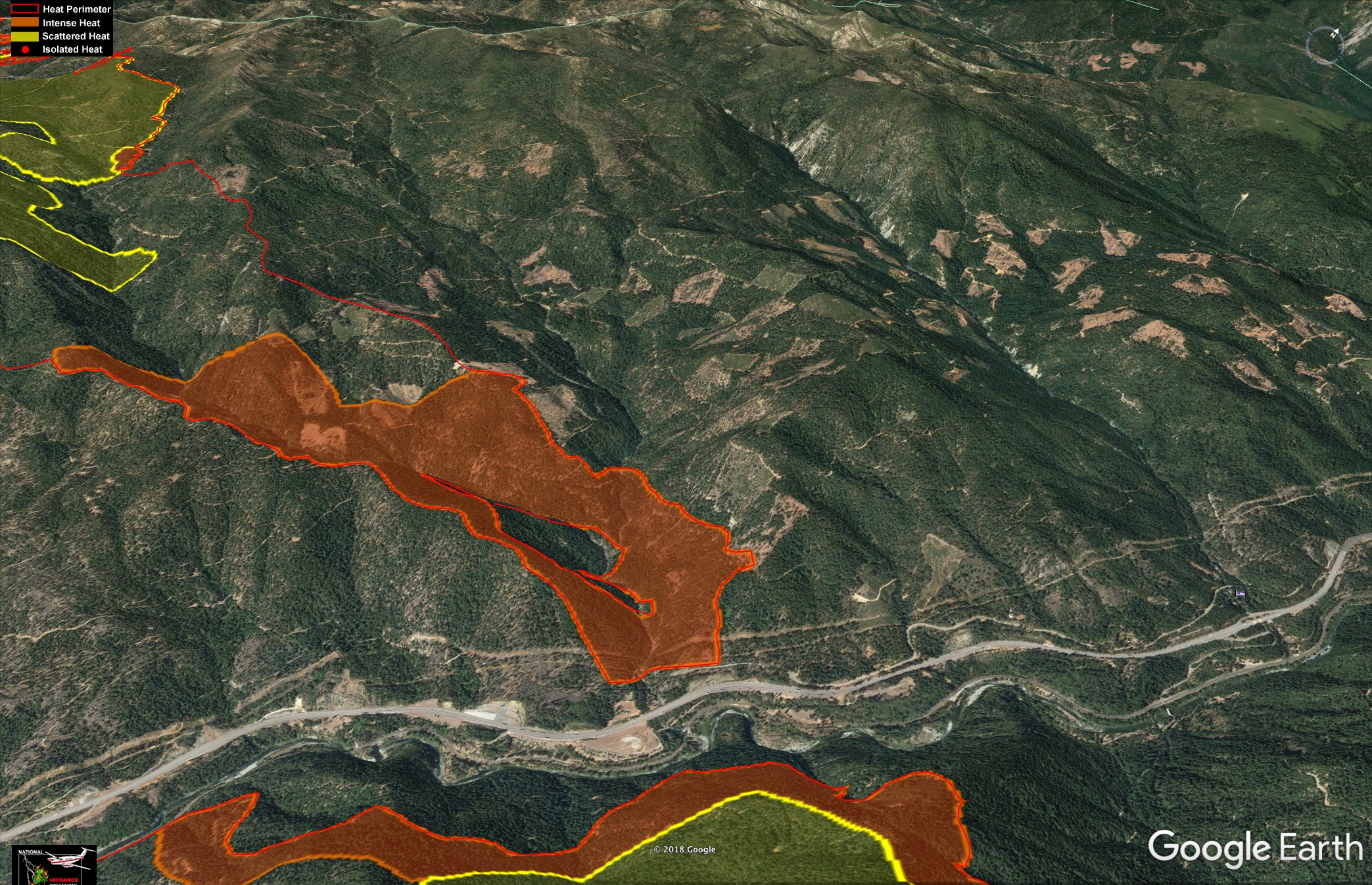
South end of the fire at Dog Creek.
1 Like
5-7 acre spot in Dog Creek drainage. “Real active” fire behavior with torching and spotting 1/4 mile ahead of itself. Continuous fuels.
Going direct with retardant on ridge on right flank (west side) and helicopters working spot fires.
Tankers 40, 94, and 95 are on load and return, one VLAT on order.
Natchez is also putting up a plume.
1 Like
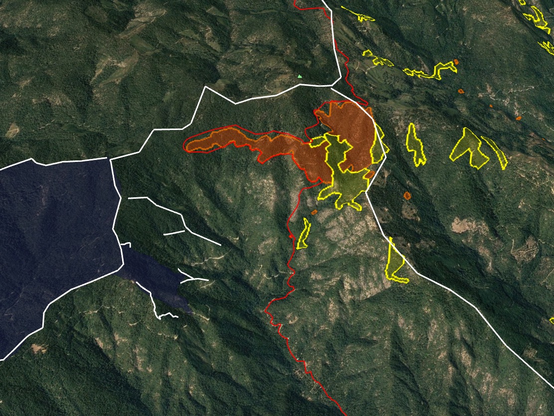
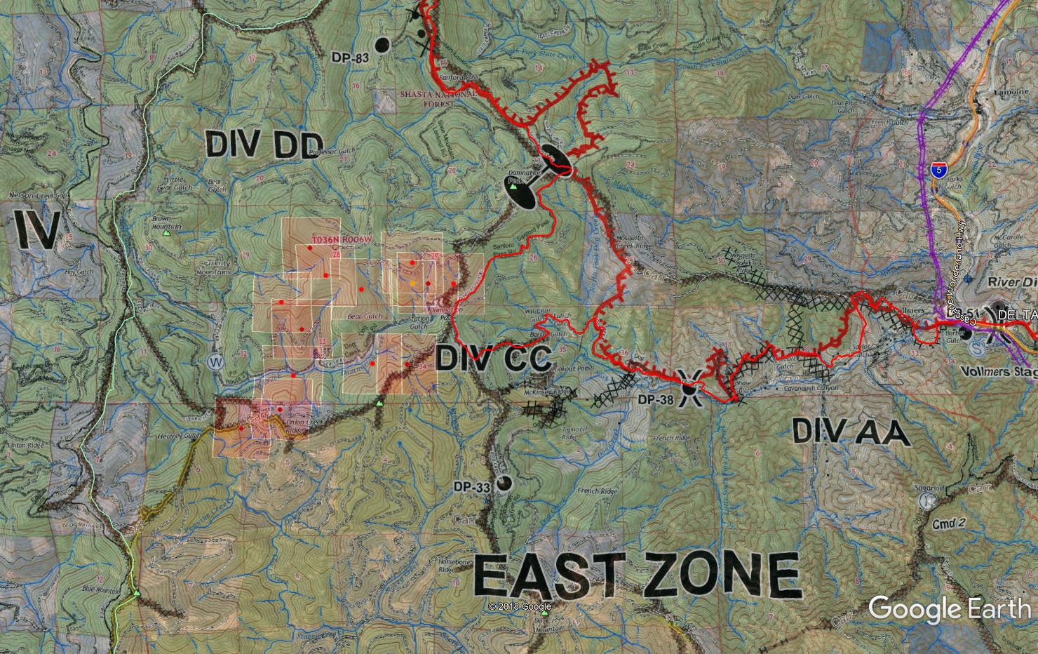
Appears to be right on Damnation Pass area of Dog Creek drainage on east side and Damnation Creek drainage on west side. DIV CC/DD and T36N R6W Sec 33 and 34. Correct me if I’m wrong, working the right/west flank would be protecting spreading west into the Damnation Creek drainage and Bear Gulch / Station Gulch area. North of the Carr fire, and a lot of open space before the next dozer line on the Ops map.
Radio traffic right now - biggest potential is to the west. Head of main fire is active, but should burn into a clear cut above it. Heavy, continuous fuel all the way to the ridge top. They have retardant on the right shoulder.
1 Like
1 Like
Main fire is 7-10 acres with a small spot to the west. Crews are laying hose
2 Likes
Delta REALLY wants to touch the Carr - it wasn’t happy with the tiny gap where they held it just South of Damnation Pass.
Crazy. I spent 12 days on the CC/DD DIVS, been home a week now. The dog creek and damnation peak/pass we’re problem areas but really thought it was bundled up good.
The Delta’s cranky little attitude is not the only one in the far north SRF/KNF as well
Visible satellite " visible fire"
The MODIS/VIIRS hits put it right where I was expecting after seeing some of the aircraft patterns yesterday and radio traffic. It put up quite the smoke column last night seen from Red Bluff and Redding. Lots of calls.
Older Ops map overlay to get the DIV info, latest IR from 9/22, which would be roughly the “final” perimeter for this area, and MODIS/VIIRS from last night.
1 Like
Local news calling it 1,000 acres
Looks more like 2,000 on norcal’s map, but the VIIRS data can be funky.
Radio traffic at aircraft pumpkin last night stated two separate fires (“spots”), so that can certainly spread/fool the heat signature on these lower resolution sensors.
I was using MODIS/VIIRS to just confirm location on what piece of line blew and what land was “open” to the spread knowing most of the spread opportunities in that area were limited with the Carr scar, and the Delta finger reaching out to the Carr there right below the Pass.
From inciweb this a.m.
Current Situation - updated 9:30 a.m.
Firefighters continued working through the night on the spot fire that was discovered in Bear Gulch yesterday afternoon. The fire was reported to be quite active over night, growing and spotting to an estimated 1,000 acres.
Night operations reported that the fire moved toward the west but still remains east of Clear Creek and north of Dog Creek Road that runs along Damnation Creek. Dozers worked through the night on forest roads along ridge tops to the north of the fire.
Firefighters will use these roads to gain access and start constructing firelines. Contingency lines are already in place having been built for the Delta Fire and recent Carr Fire.
Air Attack will arrive over the fire this morning to coordinate water dropping helicopters, water scoopers, retardant tankers and firefighters working on the ground. Boaters on Trinity Lake need to be aware of aircraft working in the area and move well out of the way.
1 Like
12pm: Significant airshow of at least 3 S2’s, 4 LAT’s and 1 VLAT
12:20pm edit: 2nd VLAT, LAT and 4 scoopers inbound from Idaho. Most likely to help get the S2’s back onto IA, but still, a lot of fixed wing moving for this.
Most aircraft taken off fire due to poor visibility. Mention of “column collapse”
2 Likes
1,500 acres per Shasta-Trinity NF post about an hour ago
The spot off the southwest corner of the #DeltaFire has been active this afternoon and firefighters are aggressively working to suppress it. The fire, located yesterday afternoon outside the perimeter of the main fire, has grown to an estimated 1,500 acres. The fire has been prevented from moving to the east because of hand lines constructed last night and retardant drops from Dog Creek Road, north to Damnation Peak.
Air tankers today are dropping retardant on the northern edge to keep the fire from advancing and to allow time for ground forces to construct firelines.
On the western edge, the fire continues to back down into the Clear Creek drainage.
This morning fire crews discovered that yesterday’s spot fire had spotted south, across Dog Creek Road and Damnation Creek, onto Onion Creek Ridge. With the support of water dropping helicopters, firefighters have encircled the 20-acre spot with a fireline and hose lay, halting any further growth.
The extremely dry conditions and rugged terrain continue to challenge firefighters.
3 Likes