Seems more likely at this point and the 1,200 they reported at 3:24 seems too low for that time…
2 Likes
I count 13 AT on the fire currently.
3 Likes
545update
Overall looking better than earlier. Plenty of heat interior in the canyons off both sides of Blue Ridge. Small piece of the head still active burning towards Old Oregon and Bear Mtn Rd, right at Tierra Oaks clubhouse. This can be seen on the Shasta Lake cam on the right side of the fire. The rest of the head appears to be settling down. Flanks are doing what flanks do, flanking and backing. Little to no growth between 330 and 510pm on the intel flights, minimal growth on the flanks. Backing down slopes on both the Mountain Gate side just east of the power transmission line fuel break seen on sat view, and down in the Bear Valley bowl there under Bear mtn Lookout, Dry Creek Rd at Bear Mtn Rd.
Tankers prepped all they could on the east side there off Bear Mountain itself, and are now prepping the west side along Mountain Gate while they have the light, clear air and aircraft. Same game, slow it down and give the ground resources a chance to catch up and tie it in.
13 Likes
Looks like they might start uploading some data, empty folder structure created at
https://ftp.wildfire.gov/public/incident_specific_data/calif_n/!CALFIRE/!2021_Incidents/CA-SHU-010480_Fawn/
1 Like
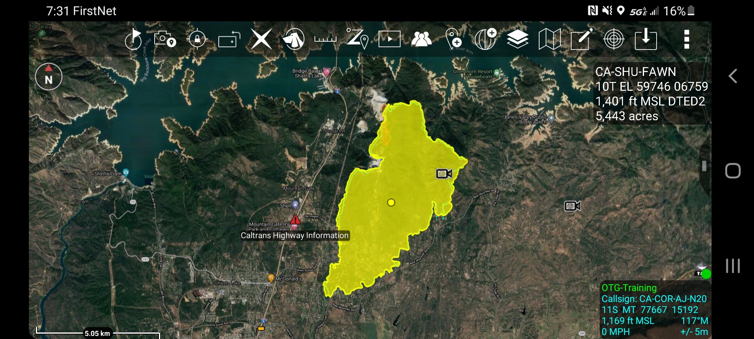
INTEL-24 conducted a second mission at 1730. Not much change in acreage.
5443 Acres plus some spots on East Flank
8 Likes
Per Action News Now, they are confirming through Cal Fire SHU that 25 structures have been destroyed in the fire so far. Unknown on type of structures.
It appears the fire has picked up some steam since sundown. Winds are predicted to pick up overnight and keep the fire active.
Some OES ST’s have been dispatched to Nor Cal from So Cal. I assume for this fire.
7 Likes
Are they only asking for Type 3’s or 6’s? Our OES T-1 is still sitting in the barn.
1 Like
Spot forecast from last night:
https://www.weather.gov/spot/php/forecast.php?snumunum=2118602.1&lat=40.75233929107472&lon=-123.13071507540961&z=8
SPOT FORECAST for FAWN INC…CAL FIRE
National Weather Service SACRAMENTO CA
621 PM PDT Thu Sep 23 2021Forecast is based on forecast start time of 2100 PDT on September 23.
If conditions become unrepresentative…contact the National Weather
Service..DISCUSSION…
Hot and dry weather conditions will continue over the fire site through
Friday as Eastern Pacific high pressure builds over Norcal. During Friday
afternoon northeast winds will begin to diminish and turn southerly as
high pressure moves over the fire site. Slight cooling and slight rise in
humidity expected on Saturday as high pressure weakens slightly over the
region..REST OF TONIGHT…
Sky/weather…Areas of smoke.
Min temperature…69-74.
Max humidity…34-39 percent.
Wind (20 ft)…
Slope/valley…North to northeast winds 5 to 11 mph.
Ridgetop…Northeast 15 to 23 mph.
Mixing height…Lowering to 200-500 ft AGL.
Transport winds…Northeast 9 to 15 mph.
CWR…0 percent.
LAL…1..FRIDAY…
Sky/weather…Sunny.
Max temperature…92-97.
Min humidity…7-12 percent.
Wind (20 ft)…
Slope/valley…Northeast winds 7 to 12 mph early in the morning
decreasing to up to 6 mph by 1100 and then shifting
to the south up to 6 mph after 1300-1400.
Ridgetop…Northeast 10 to 15 mph becoming south up to 6 mph
after 1300.
Mixing height…Rising to 4000 ft AGL in the afternoon.
Transport winds…Northeast 6 to 12 mph becoming south up to 6 mph
in the afternoon.
CWR…0 percent.
LAL…1..FRIDAY NIGHT…
Sky/weather…Mostly clear.
Min temperature…64-69.
Max humidity…39-44 percent.
Wind (20 ft)…
Slope/valley…South winds up to 7 mph shifting to the northeast
up to 5 mph after midnight.
Ridgetop…Southeast to south up to 6 mph.
Mixing height…Lowering to 0-100 ft AGL.
Transport winds…South up to 5 mph early in the evening becoming
northeast up to 5 mph after 2100-2200.
CWR…0 percent.
LAL…1..SATURDAY…
Sky/weather…Sunny.
Max temperature…87-92.
Min humidity…13-18 percent.
Wind (20 ft)…
Slope/valley…Northeast winds 4 to 8 mph shifting to the
south up to 7 mph after 1000-1100.
Ridgetop…Southeast to south up to 7 mph.
Mixing height…Rising to 4000 ft AGL in the afternoon.
Transport winds…Northeast up to 4 mph becoming south up to 7 mph
after 1000-1100.
CWR…0 percent.
LAL…1.$$
Forecaster…JM
Requested by…Aaron Williams
Type of request…WILDFIRE
.TAG 2118602.1/STO
.DELDT 09/23/21
4 Likes
DATA PACKAGE POSTED FOR THE FAWN AT MAPS.TAKSERVER.US
The first one I uploaded looks like the ops map lost georeferencing. I uploaded a replacement that appears to be working. If you see a non georeferenced ops maps delete the old package and import again.
1 Like
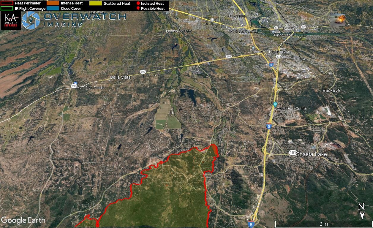
Here are some IR shots from 0124 last night showing fire perimeter and heat.
Looking NW over the NE side of fire.
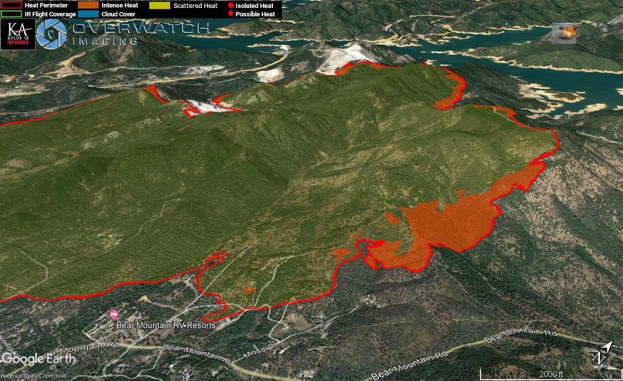
Looking N over the southern section of the fire.
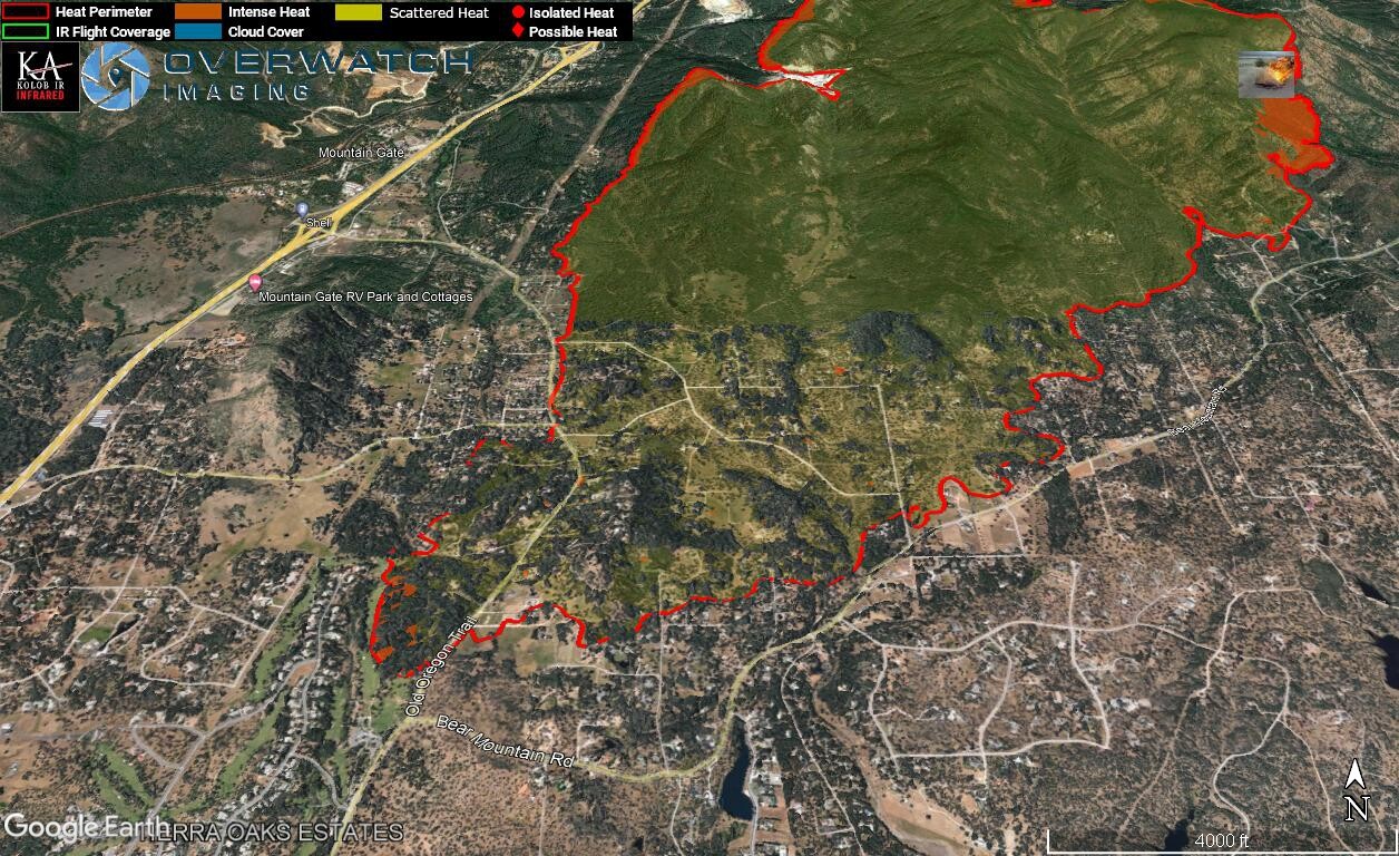
Looking E over the western edge.
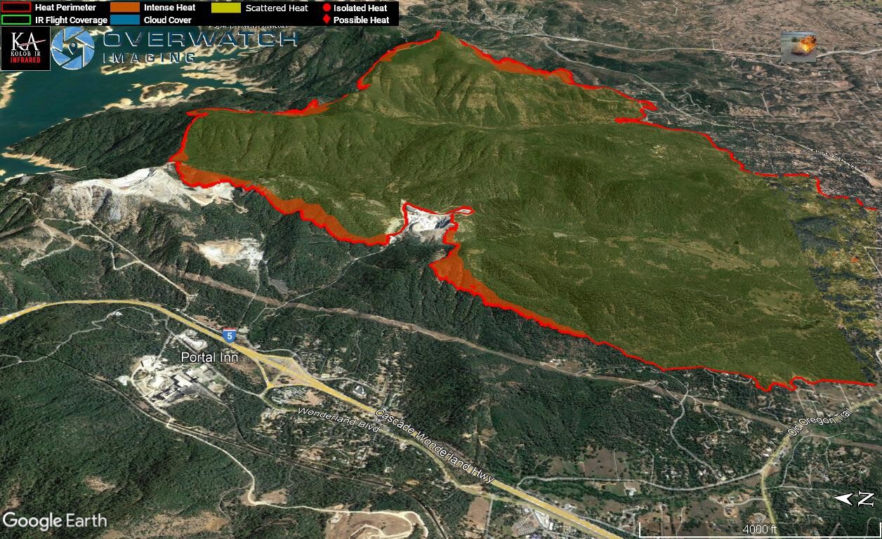
Looking S over the northern edge.
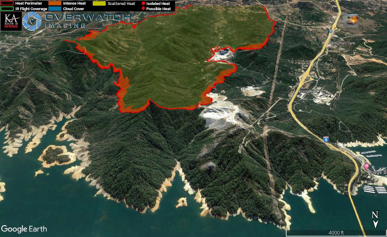
Looking S over the southern edge.
6 Likes
XSD 6431 enroute from SoCal 0500 9/24/21.
ELC,SMG,CHV,SND,SND
4 Likes
No info in this morning’s data package what about dozer or any kind of lines. File is here:
https://ftp.wildfire.gov/public/incident_specific_data/calif_n/!CALFIRE/!2021_Incidents/CA-SHU-010480_Fawn/GIS/IncidentData/
I thought I would make this map from what was in it which was perimeter and some point info. It is similar to the ops map that is included in ajohansson’s zip file but this one has a couple extra items while that one has drop points this one doesn’t have:
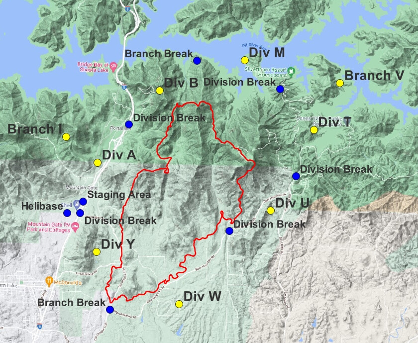
7 Likes
I put together a video tour of the fire today.

21 Likes
3 posts were merged into an existing topic: GIS and INCIDENT MAPPING
A post was merged into an existing topic: CA-SHU-Fawn???
A post was merged into an existing topic: GIS and INCIDENT MAPPING
Highline Trail cam back online, we have good eyes back on the entire east side of the fire.
7 Likes
Wind change last 2 hours:
11 Likes
1530: south winds have reached the ground in the last hour and challenging Branch 1’s lines and efforts. Numerous spots over the powerline easement with aircraft picking most of them up but a few are still unattended and burning freely. Branch and DIVS looking for addl resources.
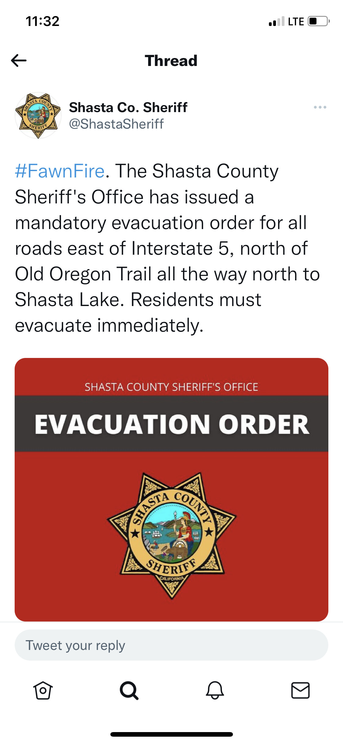
1610 update: requesting additional law support for Branch 1 (Fawndale area) for evacuees and evac efforts
4 Likes