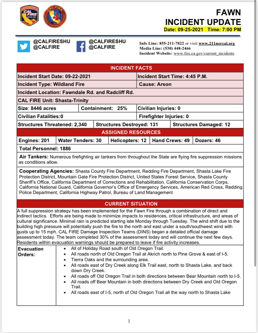
6,820 Acres, 10% Contained
2 Likes
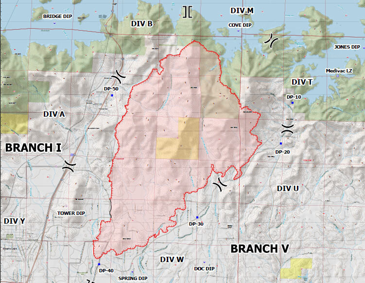
Here are updated maps using data from National Interagency Fire Center public GIS data site and IR from NIFC FTP site. NIFC GIS site is a great resource, check it out. https://data-nifc.opendata.arcgis.com/
The orange area is last night’s perimeter at 6pm. Dark red from this afternoon. Bright red/yellow from 5:20 pm.
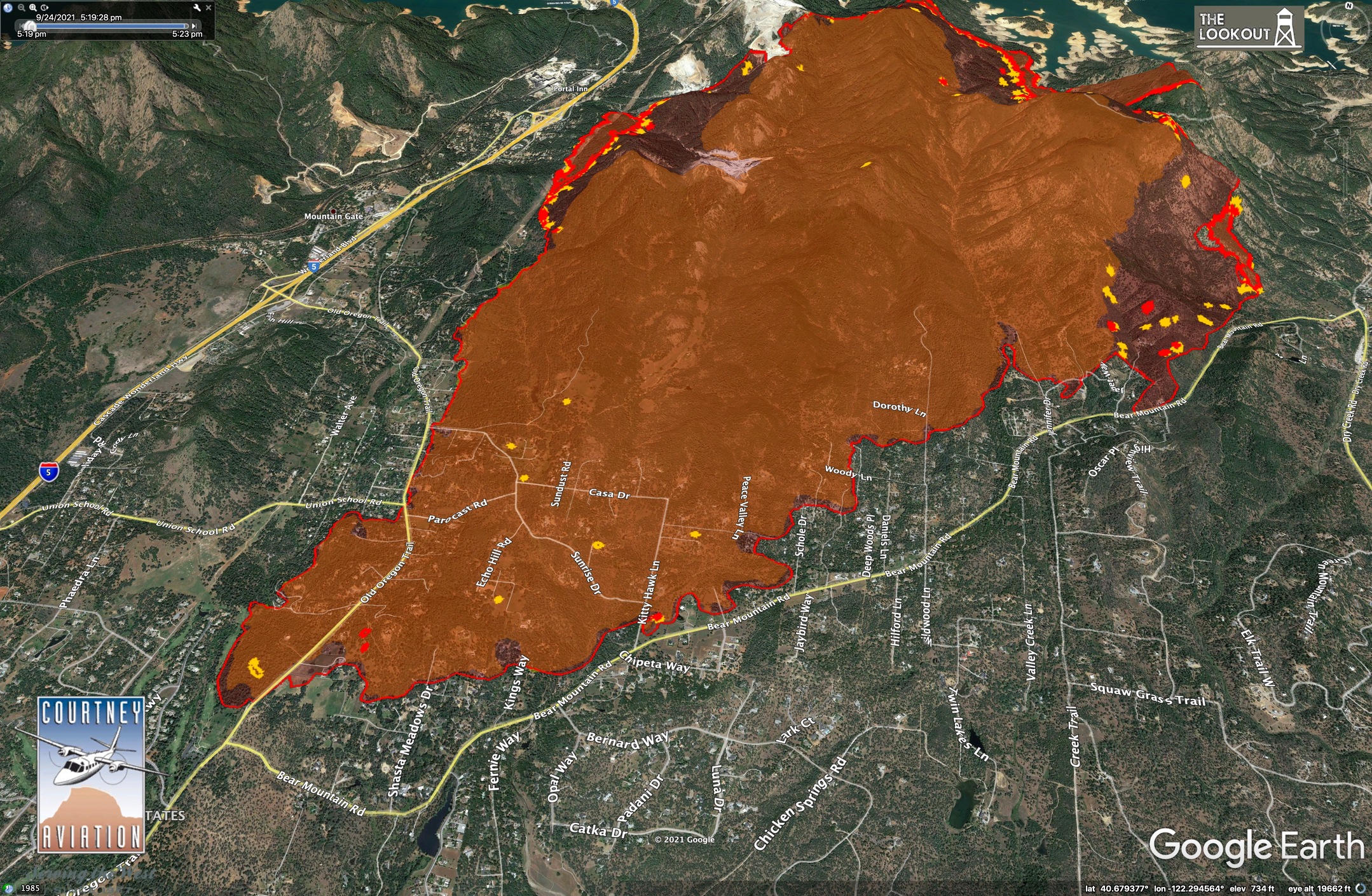
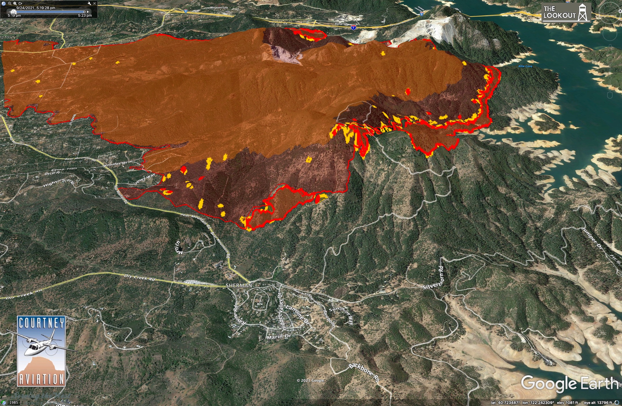
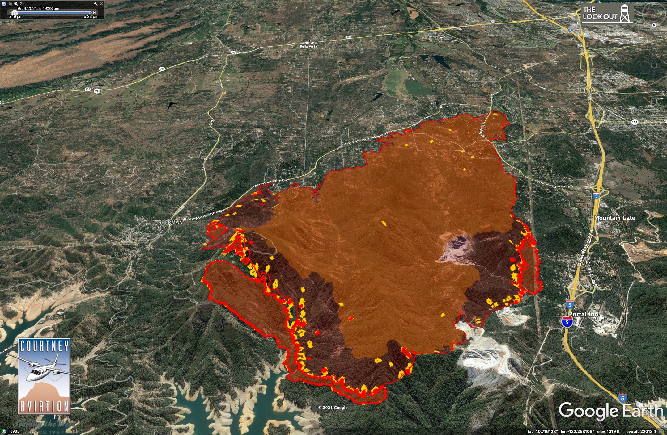

Not much spread in past 24 hours on south or SE side of fire. Fire backed actively toward Bear Valley on east flank and toward Shasta Lake on north. A pretty good run happened this evening on north flank of Bear Mtn, and fire was hot along powerline corridor near I-5 at 5:20pm.
20 Likes
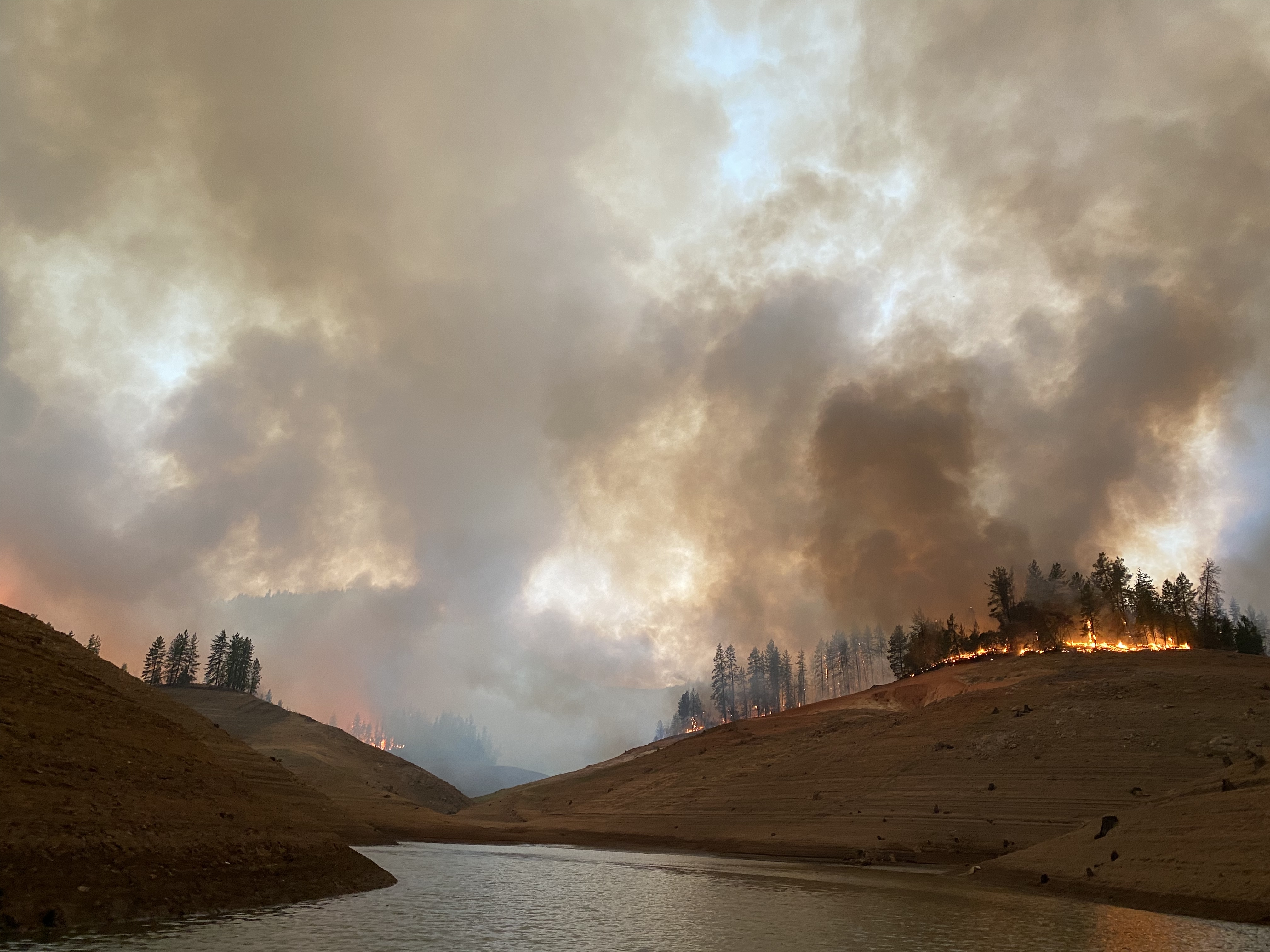
Was on the lake in Cove Creek this evening, just west of Silverthorn. Surface winds out of the north breathing with the fire and keeping air clean below the column, south winds were much higher up and keeping column low and slight NE past sundown.
Good backing ground fire all along the south shore. It got into a few dead snags but hopefully along the shore the timber between Alie and Cove Crk is intact. Can’t say the same for Bear Mtn. It roared up the NW ridge all evening, and down below on the NW base. Massive group torching and brush runs.
Could hear heavy equipment working to the east near the marina and I believe working on a line off the lookout road down into either Jones Valley or Silverthorn area to give those areas a chance.
Iphone pics don’t do it justice. One of the hotter backing fires, and then some big heat on Bear Mtn. Will check the big camera tomorrow.

21 Likes
DATA PACKAGE IS UP FOR THE FAWN - MAPS.TAKSERVER.US
5 Likes
Map tour using last night’s IR.

12 Likes
Santa Cruz County local govt type 3 strike team to Anderson Fairgrounds
7 Likes

8,446 acres timber, 25% contained.
4 Likes
3 Likes
data package is up for the fawn for the 26th. Maps.Takserver.us
2 Likes
KML files filtered from 20210926 Fawn data package found here:
https://ftp.wildfire.gov/public/incident_specific_data/calif_n/!CALFIRE/!2021_Incidents/CA-SHU-010480_Fawn/GIS/IncidentData/20210926/
For import into CalTopo, Google Earth, etc. Can’t vouch for how accurate they keep the data vs what’s really on the ground.
Contained Line. There is 1 entry:
Completed Dozer Line. There are 51 entries:
Completed All Type Of Line. There are 69 entries:
Planned All Type Of Line. There are 0 entries.
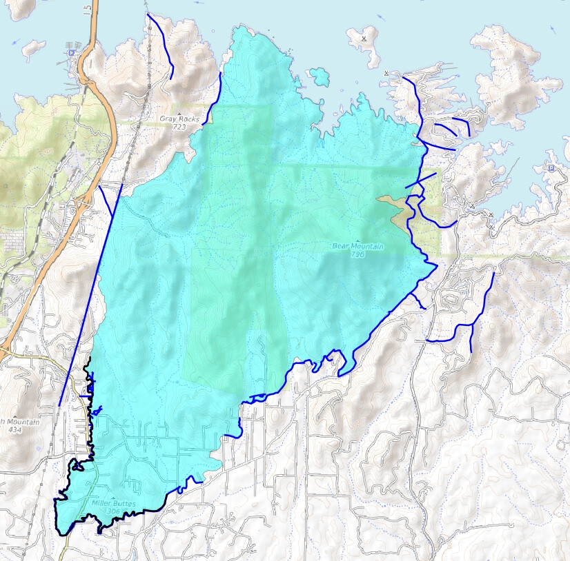
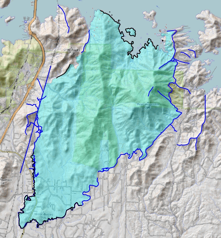
Fire Perimeter:
A map I threw together with some of this data:
Light Blue Area = “Fire perimeter”.
Dark Blue Line = “Completed All Type Of Line”.
Black Line = “Contained Line”.
2 Likes
Here is an updated virtual tour of the #FawnFire for 9/26/2021. This shows heat mapping from 9/25/2021 at 9:45pm. The fire was active yesterday on the north flank, backing down toward Shasta Lake. Southern parts of the fire did not spread. https://youtu.be/TCHL_jDlzqg
4 Likes
Last night “T” was fired to the lake, and with the mild weather the next couple days it should be wrapped up. My crystal ball says 5 - 6 days of mop up then mass demob
4 Likes
CalFire IMT 4 video update posted earlier today, 2 minutes long:
Community meeting / Press conference scheduled for 6 pm today:
YouTube: https://tinyurl.com/5hc4wwu
Facebook: https://www.facebook.com/CALFIRESHU/
3 Likes
KML files filtered from 20210927 Fawn data package found here:
https://ftp.wildfire.gov/public/incident_specific_data/calif_n/!CALFIRE/!2021_Incidents/CA-SHU-010480_Fawn/GIS/IncidentData/20210927/
For import into CalTopo, Google Earth, etc. Can’t vouch for how accurate they keep the data vs what’s really on the ground.
Contained Line. There is 1 entry vs 1 yesterday. Note that this entry is not done as I think it should be. There is only one entry yet it includes several distinct spots on the map that are not connected. See my attached map as an example:
Completed Dozer Line. There are 68 entries vs 51 yesterday:
Completed All Type Of Line. There are 86 entries vs 69 yesterday:
Planned All Type Of Line. There are 0 entries vs 0 yesterday.
Fire Perimeter:
Map.
Light Blue = “Fire Perimeter”.
Black Line = Contained Line".
Dark Blue Line = “Completed All Type Of Line”.
1 Like
data package for 092721 is available at maps.takserver.us
4 Likes
KML files filtered from 20210928 Fawn data package found here:
https://ftp.wildfire.gov/public/incident_specific_data/calif_n/!CALFIRE/!2021_Incidents/CA-SHU-010480_Fawn/GIS/IncidentData/20210928/
For import into CalTopo, Google Earth, etc. Can’t vouch for how accurate they keep the data vs what’s really on the ground.
Contained Line. There are 10 entries vs 1 yesterday:
Completed Dozer Line. There are 77 entries vs 68 yesterday:
Completed All Type Of Line. There are 97 entries vs 86 yesterday:
Planned All Type Of Line. There are 0 entries vs 0 yesterday.
Fire Perimeter:
KML files filtered from 20210929 Fawn data package found here:
https://ftp.wildfire.gov/public/incident_specific_data/calif_n/!CALFIRE/!2021_Incidents/CA-SHU-010480_Fawn/GIS/IncidentData/20210929/
For import into CalTopo, Google Earth, etc. Can’t vouch for how accurate they keep the data vs what’s really on the ground.
Contained Line. There are 3 entries vs 10 yesterday… say what? Yes, more line on the map in fewer entries than yesterday:
Completed Dozer Line. There are 104 entries vs 77 yesterday:
Completed All Type Of Line. There are 134 entries vs 97 yesterday:
Planned All Type Of line… wait for it… wait for it… yes still 0.
Fire Perimeter:
4 Likes
running interference - 3 post rule… 
4 Likes