State ID: CA
3 letter designator: SHU
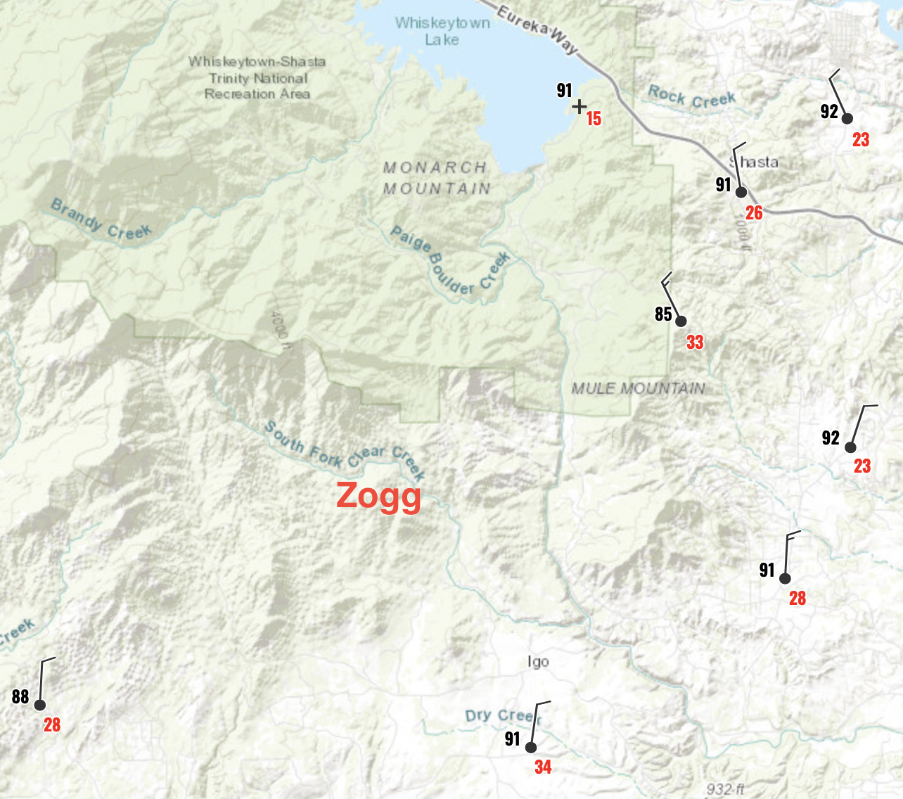
Fire name: Zogg
Location: Zogg Mine Road; Igo, CA
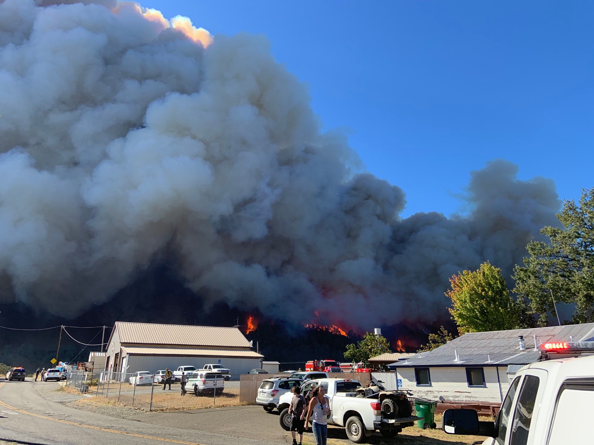
Reported acres: 100+
Rate of spread: critical
Report on Conditions: fire spotted 2 miles ahead, wind driven w/ reports of multiple civilians trapped. 10 additional engines ordered immediate need, no divert on airtankers due to immediate threat to life and property.
Structure threat: yes
Resources: 1 AA, 1 LEAD, 6 LAT’S, 4 S-2 AT’s
Hazards:
Weather: Red Flag Warning, 95 degrees, winds N 24 G 40 RH 10%
Redding WX: https://www.wrh.noaa.gov/mesowest/getobext.php?wfo=sto&sid=KRDD&num=72&raw=0
Clear Creek PGE WX: https://www.wrh.noaa.gov/mesowest/timeseries.php?sid=PG732&num=72&banner=gmap&raw=0&w=325
Radio channels:
Scanner link: https://www.broadcastify.com/webPlayer/30505
Webcam link: http://www.alertwildfire.org/shastamodoc/index.html?camera=Axis-Ducket&v=81e004f
http://www.alertwildfire.org/shastamodoc/index.html?camera=Axis-RainbowLake&v=81e004f
http://www.alertwildfire.org/shastamodoc/index.html?camera=Axis-WestPeak2&v=81e004f
http://www.alertwildfire.org/shastamodoc/index.html?camera=Axis-Eighmy&v=81e004f
Agency Website:
Portion of air attack being diverted from the Glass Fire in Napa Co. to Zogg.
IC reporting 300-400 acres
Rainbow Lake has a good shot:
http://www.alertwildfire.org/shastamodoc/index.html?camera=Axis-RainbowLake&v=81e004f

CAL FIRE IMT 2 activated. Was originally assigned to LNU-Glass but has since been diverted.
Last I knew they were still assigned the LNU glass
Team 2 is going to the Zogg.
Crowdsourced (don’t know how accurate it is) info says spotting is 3 to 4 miles out from the main fire. To the Southwest.
New evacuation orders
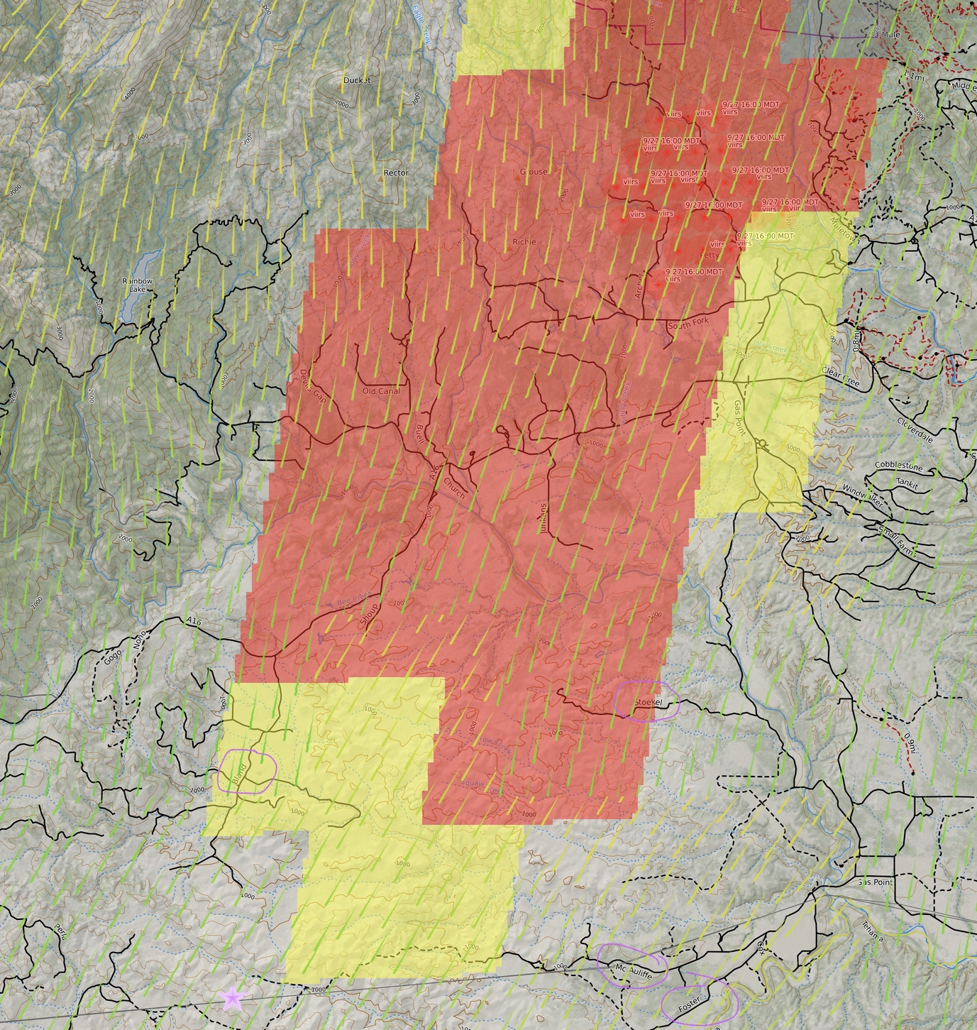
South end of this thing has road block Gas Point Rd at Foster, and CHP and SCSO setting up to potentially shut down 36 at Platina Road. SCSO went down Bowman through Tehama to 36 to avoid unpassable fire behavior and downed trees and lines on Platina towards Ono.
Well past station 57 at the moment. Going to try and hook it around Shoop Rd. Citizens in the area need to shelter around St57 with no egress.
Update, fire past Shoop Rd, trying to get dozers to Bland road to catch it in the lighter fuels.
800-1000 acres with spotting, loose estimate from AA, column laying way down and blocking visual to the head of the fire.
A post was merged into an existing topic: CA-SHU-Zogg??
CALFIRE Twitter - 7000 acres
1945:
Head of fire is still rapid rate of spread grass oak woodland. East shoulder is reaching McAuliffe, off Foster and Gas Point Road. This will be just north of the Cottonwood-Humboldt 115kv line that is prominent following the 36 corridor west. Hoping to get dozers in there to cut across to the flats at Bland Road. West shoulder still hung up in the flats around Bland Road at the moment but it won’t stick around for long.
Aircraft order for 0800 early up, 4 LAT, 3 S2, an ASM and AA.
CHP says the fire is approaching Bowman Rd. Still moving out.
Careful on that - CHP probably doesn’t understand night acres. Bowman Road nowhere near the target on this thing at the moment.
Zogg Operations is estimating the head of this will reach 36 in the area of Vestal and R Ranch around midnight, if not a bit earlier. I’m currently checking into a potential wind shift late tonight that could make it pretty warm though in that area by early morning…
3 posts were merged into an existing topic: CA-LNU-Glass???
2230:
Based on GOES fire sensors, and radio traffic, fire still seems to be held up north of the 115kv power line, so lower Bland Rd on the SW side and McAuliffe on the SE side and the Roaring Creek Drainage. Listening to Ops the dozers at the head seem to be keeping pace with the fire, and there is a some dozer work happening on the east flank from Stoekel back north to try and secure that side. The iron work at the head is giving it a good try, but realistically they’re thinking they might not be able to hook it.
Winds are still pushing from the north, sustained 12-16mph, gusts 24-28.
PGE WX has some great resolution of stations in the area.
McAuliffe - at the SE head of this thing
Bridgeville/Cottonwood - on the 115kv power line right of way, also right in the direct path of this.
Shoup - in the middle of the fire
Baker - Right heel of fire
Armchair wind forecast warning: I mentioned earlier there might be a wind shift. A friend noticed the Windy and Ventusky website was showing a potential wind out of the west after midnight. I checked those, along with historicals on the above WX stations, which also show a gentle downslope wind out of the west to the east between midnight and 6am. However everything I see on the official NWS side of things, including a spot fire weather plot for 15mi E of Cottonwood, shows winds stay N, with a little NW nudge early morning. So those diurnals Windy/Ventusky were forecasting are probably being overridden by the N winds.
Rough fire area. Purple circled road names for reference. Purple star at bottom is the 115kv line I mention - that grey line across the bottom.
Most likely my last update for evening.