If you mean “Riviera” in Redding leading upto Country Heights subdivision you are miles away from the fire. But like Marine2EMT states, you should always be ready to move.
Check the CalFire Ready set Go web site. Follow the “Go” link for some good ideas
https://www.readyforwildfire.org/prepare-for-wildfire/ready-set-go/
Anywhere near clear creek in Igo, definitely be ready and set, keep an eye on evacuation updates.
Riviera in Redding, wrong direction for now.
But always stay vigilant and listen to issued evacuations.
Thanks for all the heads up, I just think about the extremely high winds expected and if winds are in all directions, plus fire temperatures, are firenados possible especially in this county
Sta 57 :Platina road, 1 Mile south of Ono, 8 miles closer in than it used to be.
Thank you.
Any threat to the outskirts to the west of Cottonwood in Shasta County or is it still way to the west?
Cottonwood proper is okay. The head is still SSW and just about at McAuliffe off Foster and Gas Point. It’ll hit middle fork Cottonwood Crk and county line by midnight - way west of cottonwood/bowman proper.
Seems like it would take a significant wind shift for that to happen.
Do you think cottonwood creek will be able to hold as a natural fire restraint and slow down.?
I’ll make a new reply vs an edit to make sure you see this. Getting word of a wind shift due early morning that could change what I said. Let me do some armchair meteorology and get back to you. Keep an eye here or the IA thread.
Copy paste from IA thread only to follow up to some questions here and new folk who aren’t familiar with how the two threads work…
2230:
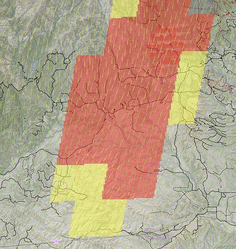
Based on GOES fire sensors, and radio traffic, fire still seems to be held up north of the 115kv power line, so lower Bland Rd on the SW side and McAuliffe on the SE side and the Roaring Creek Drainage. Listening to Ops the dozers at the head seem to be keeping pace with the fire, and there is a some dozer work happening on the east flank from Stoekel back north to try and secure that side. The iron work at the head is giving it a good try, but realistically they’re thinking they might not be able to hook it.
Winds are still pushing from the north, sustained 12-16mph, gusts 24-28.
PGE WX has some great resolution of stations in the area.
McAuliffe - at the SE head of this thing
Bridgeville/Cottonwood - on the 115kv power line right of way, also right in the direct path of this.
Shoup - in the middle of the fire
Baker - Right heel of fire
Armchair wind forecast warning: I mentioned earlier there might be a wind shift. A friend noticed the Windy and Ventusky website was showing a potential wind out of the west after midnight. I checked those, along with historicals on the above WX stations, which also show a gentle downslope wind out of the west to the east between midnight and 6am. However everything I see on the official NWS side of things, including a spot fire weather plot for 15mi E of Cottonwood, shows winds stay N, with a little NW nudge early morning. So those diurnals Windy/Ventusky were forecasting are probably being overridden by the N winds.
Rough fire area. Purple circled road names for reference. Purple star at bottom is the 115kv line I mention - that grey line across the bottom.
Most likely my last update for evening.
Did the Zogg get on Whiskeytown National Park?
the heel is right at the park boundary. Dropping lots of retardant on the heel to help button that up while they have a chance up there.
Doubt it. Pyrogeography’s post today shows it miles away. As was explained on local radio Q97 they were told Whiskeytown was closed because they are using the lake for a water source and don’t need folks on the lake getting in the way. ModCamo stated yesterday two Scoopers were on order for today. They need room.
Per air traffic, sounds like they’re making good progress on the ridge system south of Kanaka Creek, and south of the main ridge that has the bulk of the southern park boundary. Major focus on that and the left heel keeping it west of Clear Creek.
I’m sort of at a loss for how this is being treated south of Cottonwood Creek into Tehama County and TGU. TGU is sort of treating it as a new incident right out of the ECC with IA tactical and such. TGU Div Chief sort of crashing the party on Zogg Command asking what’s the story. Major transportation delays to get resources from the SHU side to the TGU side of the creek.
I try to not let my opinion show often, but this situation is interesting.
August Zogg Zone has a nice ring to it… 
Maybe that Division Chief should get with the program and work with the IMT that’s assigned to accomplish the same mission 
careful guys, maybe he was not getting the communication he needed to get. Jakes correct. Its a long drive from the No. side of Cottonwood creek to get in front of the fire on the So. side of Cottonwood creek. He might have a reason… Im just not gonna sit in the balcony and complain about the play till its over…
