Anderson Flat
Use the settings 0 - 6 and 6 - 12 for a better view of your mapping. Play around with it a bit and learn how it works. ArcGIS is nice.
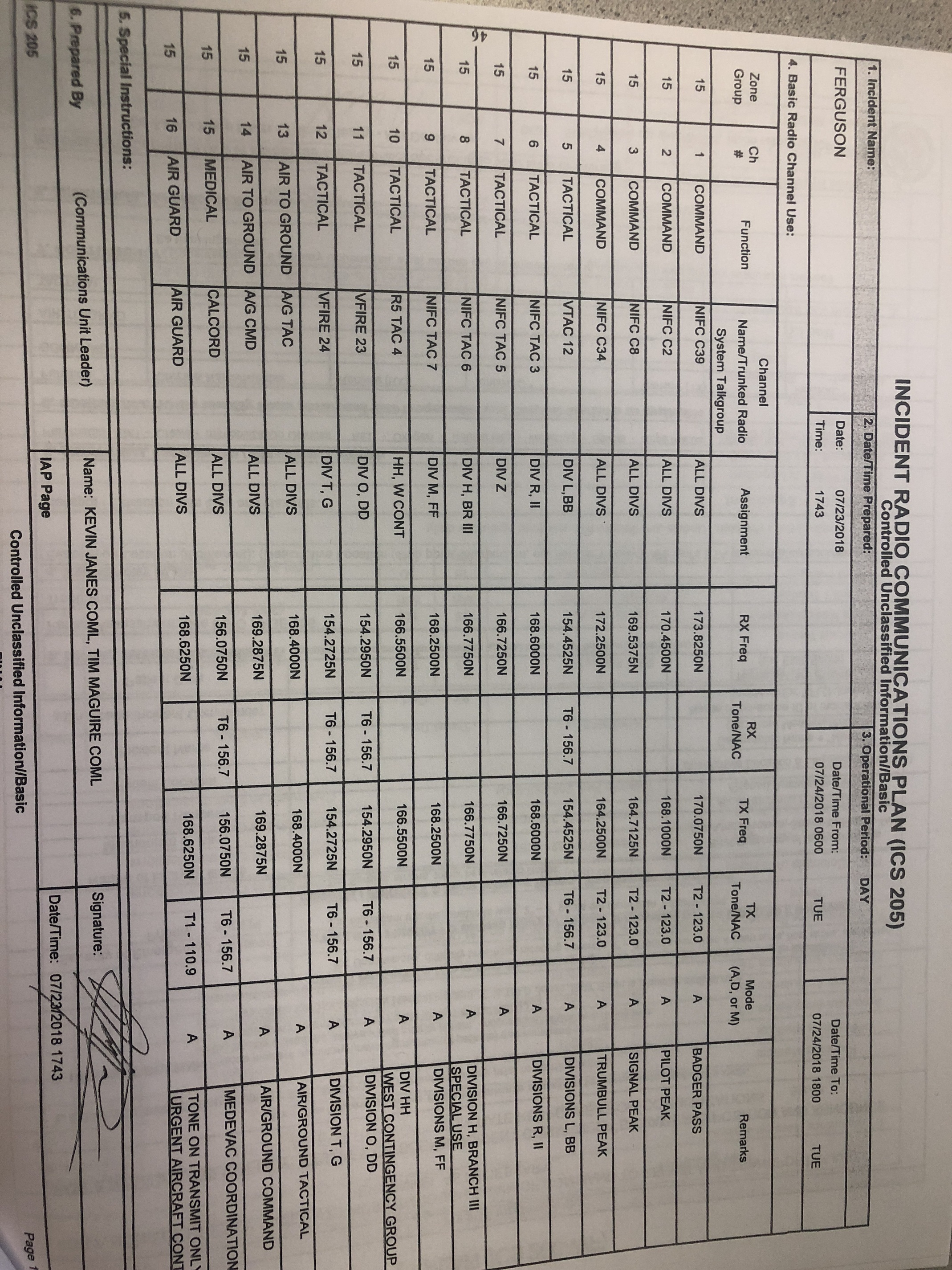
Good Morning, Does Anyone Have A Current 205 And Or A 220 For The Ferguson That They Could Share? Thanks
1 Like
Amazing how bad the smoke actually is.
Yosemite National Park announces Yosemite Valley and Wawona will close at Noon tomorrow, July 25, 2018, to all visitors due to the ongoing impacts of the Ferguson Fire. This will in effect close Hwy 41 into YNP. These closures include all hotels, campgrounds, and visitor services in Yosemite Valley and Wawona. Park visitors currently staying in park campgrounds and lodging facilities are asked to be out of these areas by Noon tomorrow. With the ongoing closure of Highway 140, park visitors can exit the park via Highways 120 and 41. The temporary closure is expected to last until Sunday, July 29, 2018. The Mariposa Grove of Giant Sequoias is closed.
This will leave only SR120 open into and through the park.
Thanks for getting this out! Good COML’s
1 Like
Thank You!
1 Like
anyone have a link to a IAP
There won’t be a link, Fed incidents don’t post their IAPs
2 Likes
only iap i have seen is all maps only no other docs
1 Like
The feds don’t post IAPs to the FTP site because they consider the phone numbers on the 205A to be sensitive info.
http://www.fusee.org/rim-fire-redux/
Check out my new blog post about the Ferguson Fire on FUSEE.org
5 Likes
Interesting and well written. Thanks!
1 Like
This fire is #1 on the national news but there is very little info on this site.I have friends on the fire and am being affected by the drift smoke. Sure wish there were away to get more updated info.
1 Like
The fire has been fairly quiet activity wise. The air has been to lousy for tanker to fly. Most active section of the fire is division romeo.
1 Like
Thank you for that
2 Likes