Not yet. Radio traffic is broken.
1 Like
What is the Command and AG for the fire?
3 Likes
We have another pyrocumulonimbus lightning event.
https://rammb-slider.cira.colostate.edu/?sat=goes-17&z=4&im=18&ts=1&st=0&et=0&speed=130&motion=loop&map=1&lat=0&opacity[0]=1&opacity[1]=0.5&hidden[0]=0&hidden[1]=0&pause=0&slider=-1&hide_controls=1&mouse_draw=0&follow_feature=0&follow_hide=0&s=rammb-slider&sec=conus&p[0]=cira_glm_l2_group_energy&p[1]=band_04&x=8122&y=4029
2 Likes
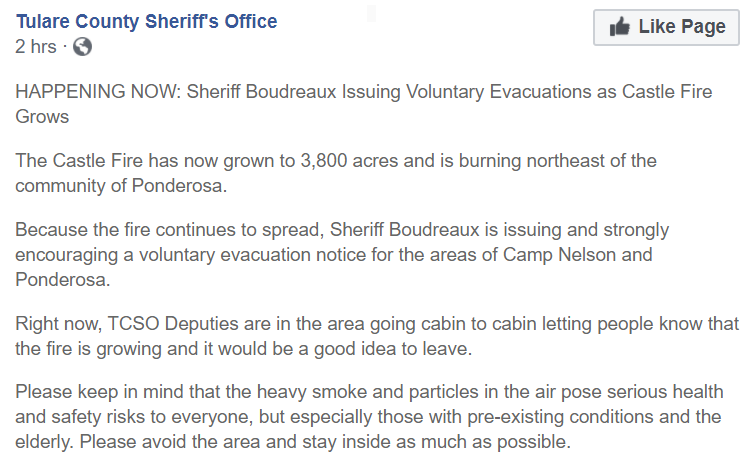
3800 acres.
1 Like
A portion of pyrocumulus moved off to the west and has become a small thunderstorm between Clovis and the foothills.
https://radar.weather.gov/ridge/radar_lite.php?rid=hnx&product=NCR&loop=yes
I don’t have complete info, but some voluntary Evac notices have gone out for the Ponderosa area and areas east of Camp Nelson. People I know are bombarding me with private messages for info as they’ve received texts on their phones. There is very little intel/info reaching the public yet. Tulare county fire has nothing on their site yet as well. Communications are limited as well. I will update if I get any hard info. This area is just a bit north of where I live up here.
3 Likes
No inversion to speak of now and hasn’t laid down a lot. Breckenridge is showing active fire.
http://www.alertwildfire.org/sierra/index.html?camera=Axis-BreckenridgePeak1&v=81e004f
2 Likes
It is really taking off now. Breck timelapse paints the picture.
2 Likes
Add Shirley Meadows to the mix. Cooking. http://www.alertwildfire.org/sierra/index.html?camera=Axis-ShirleyPeak1&v=81e004f
1 Like
Wow, that was fast.
A little behind which is typical, but …
Joe Brabender, a fire management officer with the U.S. Forest Service said “The fire is spreading in extremely tough country; it’s almost impenetrable.” and it is now estimated at 15,000 acres.
1 Like
8 posts were merged into an existing topic: CA-SQF-Castle?
Looking at the RMMB/CIRA SLIDER the Castle is showing brighter than any place else in the state. They still can’t get a NIROPS and don’t know where it really is.
They still only have 6 Porterville crews and a couple of WFU modules and aren’t getting much else. I’ve been working with the team helping with logistics support.
7 Likes
@TheBrushSlasher that is what I was thinking, bumping into McNally or not. If I recall, the McNally stayed on the east side of the main Kern and south of Jordan Hot Springs. I know the East side of the Kern adjacent to the Castle burned in the Lion. So, the area burning now has not been touched by fire recently that I can think of, other than what @OldGuy said, back on '61.
1 Like
That is some serious heat chief. Thank you for this.
The fish fire from 2013 has been burned through already and the 09 grouse fire may be already burned these weren’t big enough fires to effect fuel loading much.
2 Likes
Ah, possibly explains the heat then. Much appreciated sir.