I was saddened to learn of the loss of the Mule Peak Lookout, reported on the 23rd, despite being wrapped. Another historic lookout gone.
Anyone have a good LRA/SRA/FRA map with a fire overlay? Thanks in advance
It’s a long way from any LRA, but if it continues west it will be on SRA soon. No maps, other than what’s in my head from being all over the southern end of this area.
@IMT_Geek its basically your old stomping grounds right? I feel like you could have some answers for some folks here.
the kml is available from the state-
If you want to get the data directly its here.
This map shows this mornings IR, latest VIIR and SRA/FRA/LRA.
I won’t be updating the perimeter on this map- but the VIIR updates automatically.
True, for about a dozen years the last round. But I was usually on the roads, @Buffalohead was either walking or leading a dozer on the slopes, so he has a better feel for the on the ground ground-truthing aspect of some beautiful, but person unfriendly terrain.
The SRA/FRA question has been answered. West and south. I’'d say a long ways off right now, especially with the “normal” wind patterns of past years. BUT, as soon as I say that then the fire may prove me wrong.
As far as fire behavior? I’ll join and agree with the FBAN folks who have scabs from continually scratching their heads over what fire behavior has been like this year. Add to that some of the Wx patterns and odd results and, well, sometimes not saying what you think might happen is better because the way fires are (mis)behaving you may not want any preconceived ideas, but let the IMTs consider any and all possibilities in their planning processes. This year, if you can conjure it up in your head, ya better walk through some “what ifs” and consider probability. Those that know will understand → this year OSC’s should spell PACE as PAAACCCE. Everyone deserves to come home healthy at the end of their deployment.
@simiweather, one of them, and it might have been Mule Pk, (or Delilah) in the late 70’s during the late night hours would quote and espouse scripture, sometimes for hours. The USFS and the use of lookouts were new to me at that time, and I found that uniquely captivating. But that is another thread for another time - back to the Windy!
I have seen this area change for a long time. After the Stormy and McNally burned on the east and south sides of this, I watched the brush overtake the roadways up there. Got to fly over the area a few times too, which really revealed the severe fuel loading that is burning now. My nightmare fire was one that would start at Poso Creek and the Tulare/Kern line and run up through Posey into Sugarloaf. Never envisioned one running East to West like this one. At least people are able to leave the area with the current situation.
It isn’t a “good” one, but it might give you an idea of where it is in respect to the DPAs and the IR from today. The SRA is a lot closer on the west than I thought. You can see Lake Isabella and Kernville at the southern border of the map, about 10 miles as the crow flies. Someone with time and patience and skills can make it a lot prettier and readable.
TIA-Windy DPA Map.pdf (1.0 MB)
The fire progression map just posted on the “Continuing Fires” side of the Windy thread really shows what you had nightmare’s about. Sugarloaf, Guernsey Hill, White River Tract are just right there. From the posts on that side it sounds like KRN had to get involved and punch out resources too. Like the other earlier fires we have been monitoring, apparently this one is going to do “stuff” we just haven’t previously fathomed as possible.
Thank you all, the maps and insite are awesome. I’m vaguely familiar with this area, that Southern end is vary worrisome.
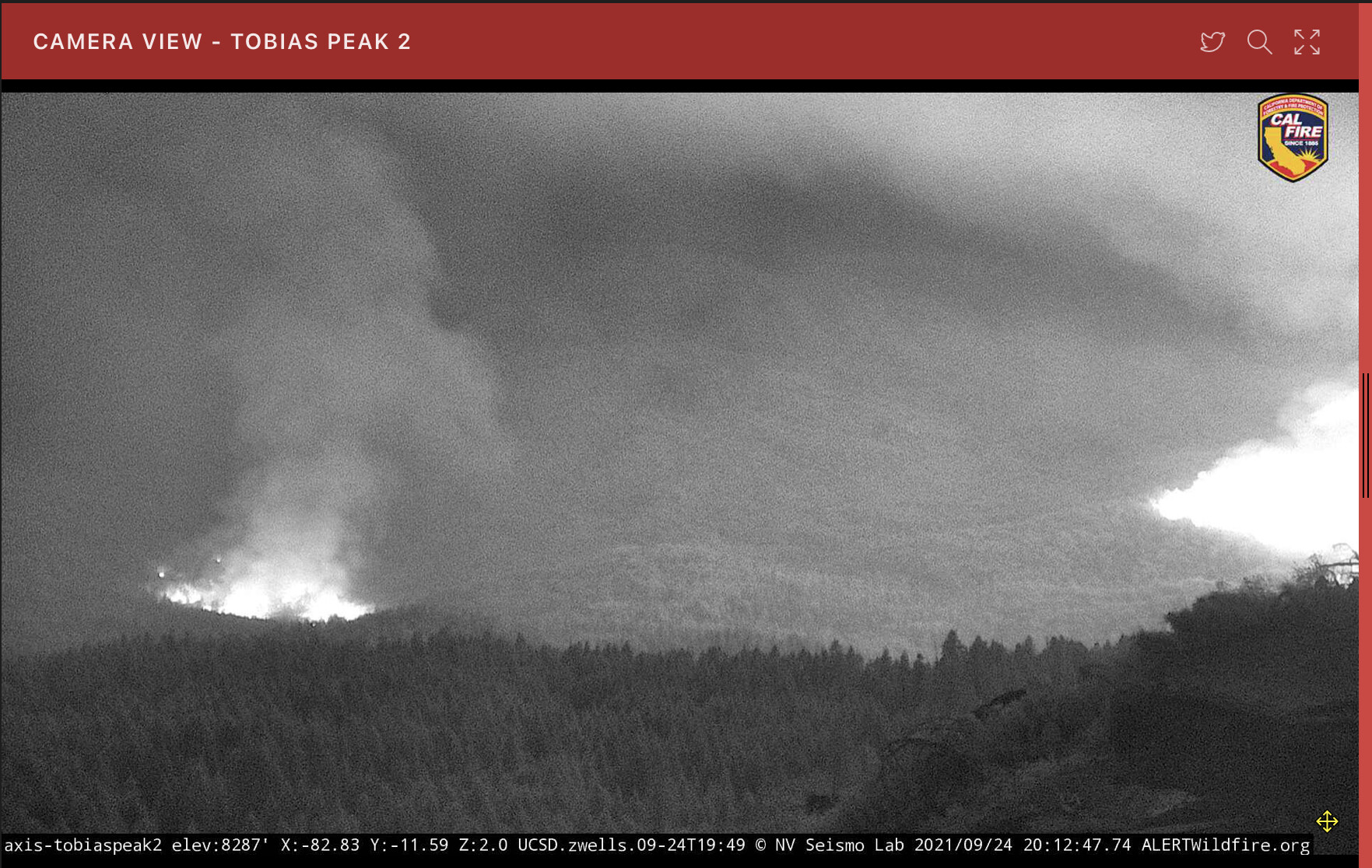
The Tobias camera is back up. It looks like it will take a direct hit before the day is over.
I read that Mule Peak lookout burned despite protective measures. Any confirmation?
Mule Peak was a victim.
Tobias has a large clearing around it.
Just left there this morning. There is a spot in the drainage that is causing concern to the North of Sugarloaf but when I left 2 hours ago it was all good
see link I just posted…
Re: Sugarloaf… I know they had some folks in there yesterday and were scraping up more spare resources this morning. Heard some traffic about a spot fire in a drainage below some cabins near Sugarloaf last night but nothing since. That Tobias camera activity is pretty telling thought