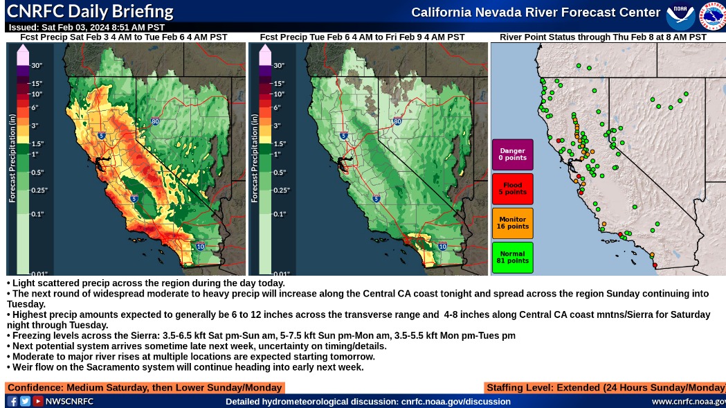
Summary:
- Light scattered precip across the region during the day today.
- The next round of widespread moderate to heavy precip will increase along the Central CA coast tonight and spread across the region Sunday continuing into Tuesday.
- Highest precip amounts expected to generally be 6 to 12 inches across the transverse range and 4-8 inches along Central CA coast mntns/Sierra for Saturday night through Tuesday.
- Freezing levels across the Sierra: 3.5-6.5 kft Sat pm-Sun am, 5-7.5 kft Sun pm-Mon am, 3.5-5.5 kft Mon pm-Tues pm
- Next potential system arrives sometime late next week, uncertainty on timing/details.
- Moderate to major river rises at multiple locations are expected starting tomorrow.
- Weir flow on the Sacramento system will continue heading into early next week.
Confidence: Medium Saturday, then Lower Sunday/Monday
Staffing Level: Extended (24 Hours Sunday/Monday)
Detailed Hydrometeorological Discussion: cnrfc.noaa.gov/discussion
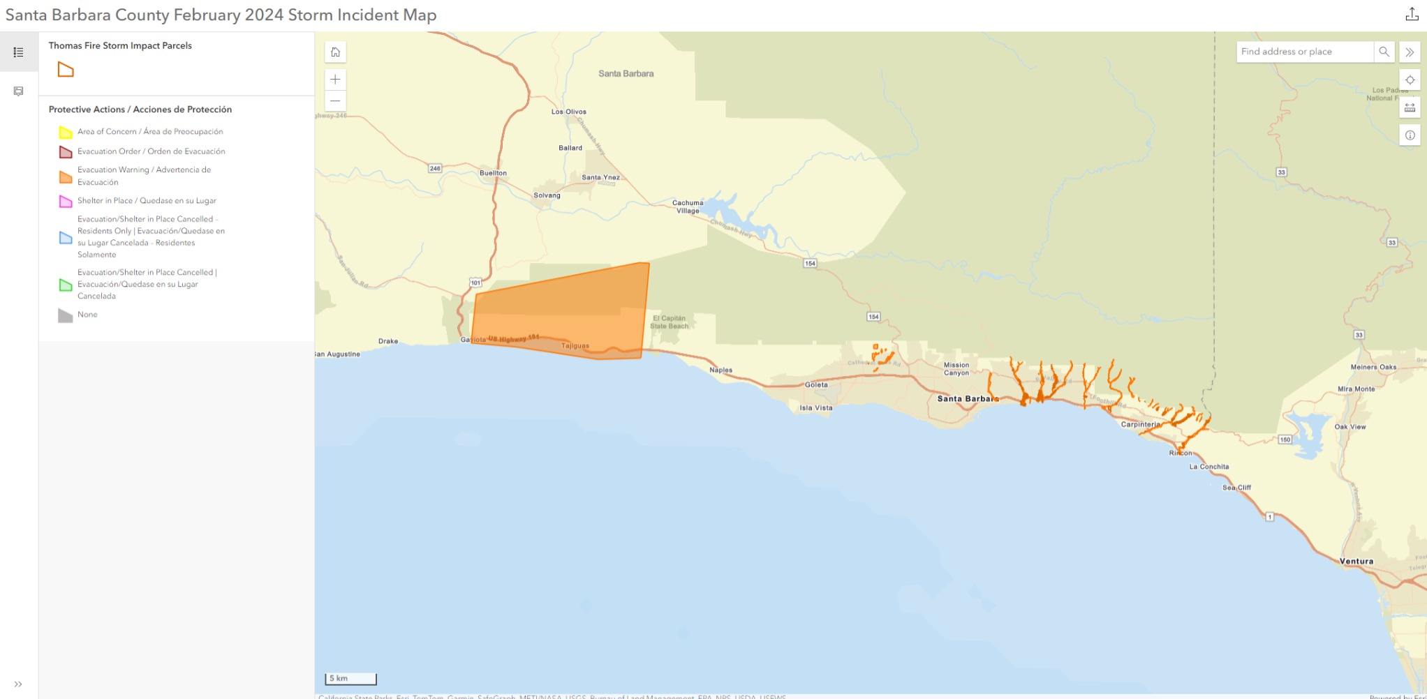
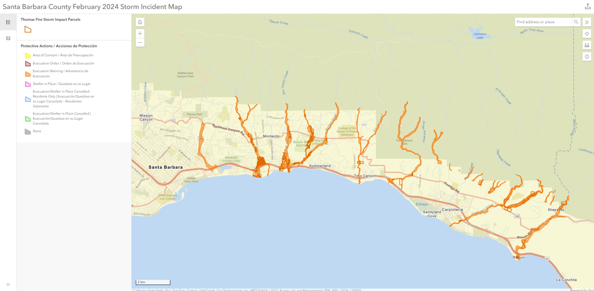
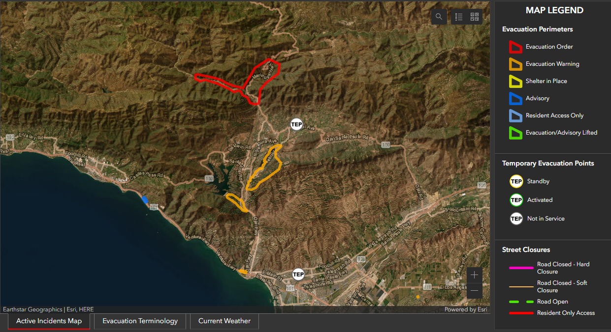
Evacuation Warnings for Santa Barbara County
EVACUATION WARNINGS have been issued for the following areas in Santa Barbara County:
- Properties along waterways associated with the Thomas, Cave and Alisal burn areas.
- Properties in the vicinity of Sycamore Creek, from Stanwood Dr. down to parts of Ninos Dr., in the city of Santa Barbara.
This EVACUATION WARNING is due to an incoming storm arriving Saturday, February 3 through Tuesday, February 6 with the potential to produce flash flooding, debris flows and landslides.
Click here to access the interactive incident map.
The EVACUATION WARNING is in effect until further notice and may be upgraded to an Evacuation Order unless there are significant changes to the weather forecast.


Evacuation Orders and Warnings for Ventura County
EVACUATIONS
For a detailed map of all evacuation areas, please visit the Realtime Incident Dashboard
EVACUATION ORDERS – Effective 2/3/24 at 5:00PM
- Matilija Canyon / North Fork / Camino Cielo (Unincorporated Ojai)
EVACUATION WARNINGS – Effective 2/3/24 at 5:00PM
- Ventura RV Resort (City of Ventura)
- Community of Foster Park / Camp Chaffee (Unincorporated Ventura)
- Old Creek Road. / Creek Road (Unincorporated Ojai)
- 4 structures on Grada Avenue & Trueno Avenue (Unincorporated Camarillo)
ADVISORY – Effective 2/3/24 at 5:00PM
- Community of La Conchita
- An advisory has been issued to residents that live in the Community of La Conchita due to the volume of rain expected to saturate hillsides above the area. Over the last 14 days, La Conchita has received nearly 4 inches of rain with a potential to receive an additional 3”-5” over the next 5 days. This amount of rain will likely cause the soil to become saturated and may result in landslides or debris flows.
EMERGENCY EVACUATION SHELTER
An Emergency Evacuation Shelter will be available to residents impacted by the storm starting Sunday February 4, 2024, at 9:00AM.
Ventura College Gymnasium
4667 Telegraph Road
Ventura, CA 93003ROAD CLOSURES
- Lockwood Valley Rd. from Chico Larson Rd. to Hwy 33.
SAND BAGS
- Ventura County Fire has a list of locations https://vcfd.org/sandbag-stations
- San Jon Maintenance Yard – 336 Sanjon Rd.
- Camp Chaffee Rd. and Casitas Vista Rd.
- Moorpark City Library – 699 Moorpark Ave.
- College View Ave. – South of Campus Park Dr. in Moorpark
Additional forecast information can be found on the National Weather Service websites
1 Like
2 Likes
2 Likes
Evacuation Warnings for Monterey County
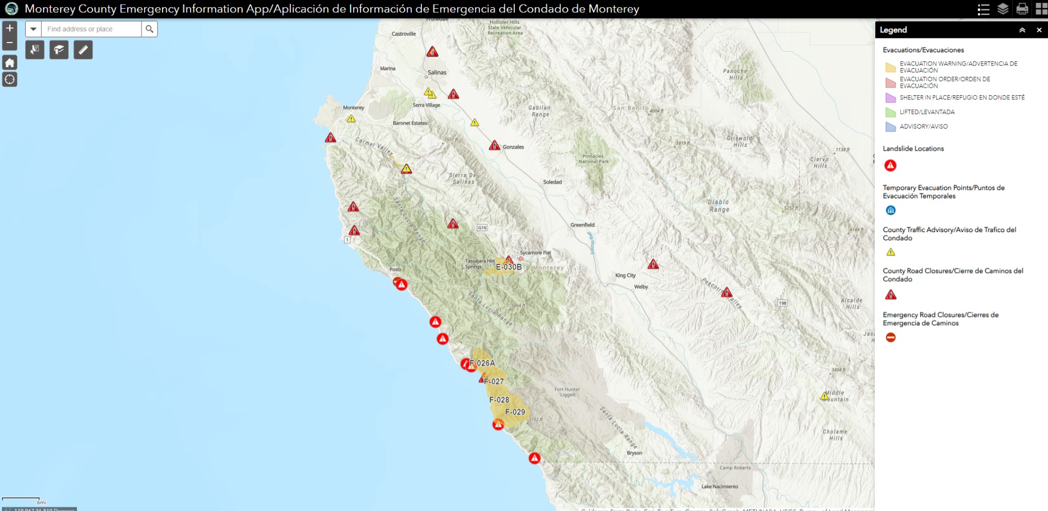
The Monterey County Sheriff’s Office has issued an Evacuation Warning for areas of the Carmel River in the Communities of Camp Steffani, Paso Hondo, and areas near Shulte Rd in effect 1:00 PM today, Saturday, 2/3, and until further notice due to the incoming storm. The Carmel River is anticipated to reach flood stage on Sunday.
If you are in an Evacuation Warning Zone prepare to leave. Be ready to leave if an Evacuation Order is issued. Gather essential items now to be ready to go. If you feel unsafe, do not wait for an evacuation order, leave immediately. Check with your neighbors to ensure they have been made aware of this alert.
Those with large animals should leave now; For animal sheltering call the SPCA 831-373-2631. SPCA After Hours Line 831-646-5534.
Monitor local media, social media, and Nixle alerts for updates. Call 2-1-1 for information. Call 9-1-1 only if you have a life-threatening emergency.
To view an Evacuation Map: bit.ly/3Za0Xc0
Monterey County Emergency Information App
Monterey County Emergency Information App/Aplicación de Información de Emergencia del Condado de Monterey (arcgis.com)
2 Likes


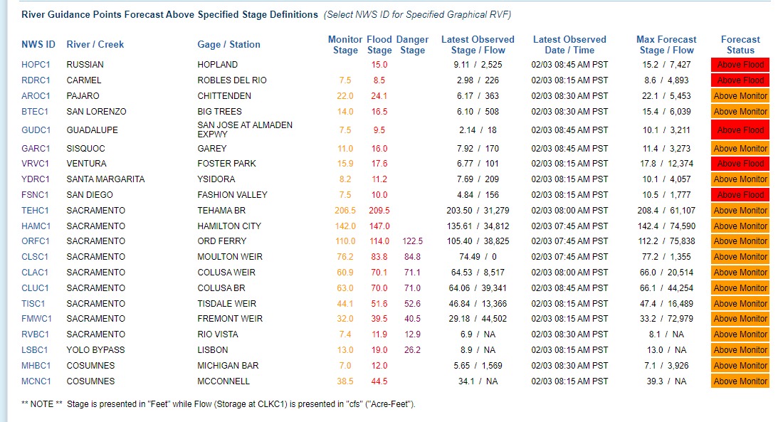
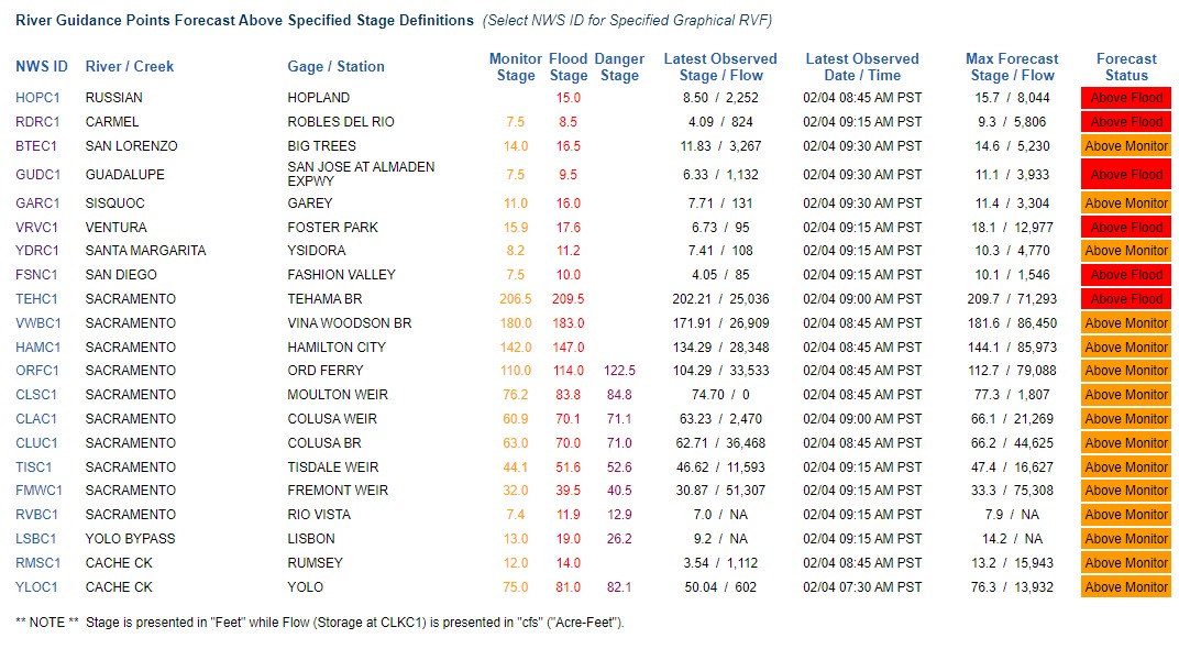
Flood Warning issued February 3 at 5:02PM PST by NWS San Francisco CA
…The National Weather Service in San Francisco CA has issued a
Flood Warning for the following rivers in California…San Lorenzo River at SAN LORENZO RIVER A BIG TREES affecting
Santa Cruz County.A strong weather system will result in excessive rainfall that is
expected to lead to rapid rises along the San Lorenzo River at Big
Trees overnight tonight into Sunday afternoon.For the San Lorenzo River…including SAN LORENZO RIVER A BIG
TREES…Moderate flooding is forecast. The San Lorenzo River at Big
Trees is expected to rise into flood stage by mid morning on Sunday,
cresting to 19.7 feet around noon on Sunday.
WHAT…Moderate flooding is forecast.
WHERE…San Lorenzo River at SAN LORENZO RIVER A BIG TREES.
WHEN…From Sunday morning until further notice.
IMPACTS…At 19.5 feet, Moderate Flooding. The St. Bernard Street
area in Paradise Park is under several feet of water, with below
grade floodplain infrastructure several feet deeper. St.
Augustine Avenue neighborhood in Paradise Park begins to flood.
Flooding imminent or already occurring in the Felton Grove
neighborhood. Ground stories, first floors, and garages flooded.
Felton Covered Bridge Park begins to flood.ADDITIONAL DETAILS…
- At 4:45 PM PST Saturday the stage was 5.9 feet.
- Bankfull stage is 17.0 feet.
- Forecast…The river is expected to rise to a crest of 19.7
feet early tomorrow afternoon. It will then fall below flood
stage early tomorrow afternoon.- Flood stage is 16.5 feet.
- Flood History…This crest compares to a previous crest of
19.7 feet on 03/02/1983.
4 Likes

That river is gonna get 10 feet higher by tomorrow night. When the water is 10-12 ft above the ground, that is completely inundating the first floor of a typical platform construction building. People have been trapped inside structures, in attics, lofts, even a second story or split level, because there was no access to the roof. Continued pressure can also collapse structures by undermining their foundations. When in doubt, get out, and get the high ground.
3 Likes

Summary:
- Widespread moderate to heavy precip across the region today and tomorrow diminishing into Tuesday. Chances of thunderstorms this afternoon/evening, particularly along the coast from Point Concpetion northward to the South Bay.
- Highest precip amounts expected to generally be 6 to 12 inches across the transverse range, 2-6 inches along Central CA coast mntns, and 2-7+ inches over the Sierra through Tuesday.
- Freezing levels across the Sierra: 3.5-7.5 kft Sun am, 5-7.5 kft Sun pm-Mon am, 3.5-5.5 kft Mon pm-Tues pm
- Additional precipitation possible sometime late next week, uncertainty on timing/details.
- Moderate to major river rises at multiple locations are expected in the Central Coast and Southern California areas today into tomorrow.
- Weir flow on the Sacramento system will continue heading into early next week.
- High tides at Rio Vista are expected to be above monitor stage for the next couple days.
Confidence: Medium Sunday, then Lower Monday onwards
Staffing Level: Extended (24 Hours Sunday/Monday)
Detailed Hydrometeorological Discussion: cnrfc.noaa.gov/discussion
1 Like
Not quite ready to declare the fall of the government, sir. Be safe out there.
3 Likes

Ventura River at Foster Park. Currently looking to gain 12’ ft today, with a crest of 18.09’ ft at 10PM PT.
2 Likes
Reed Timmer Live Feed from Santa Barbara
1 Like
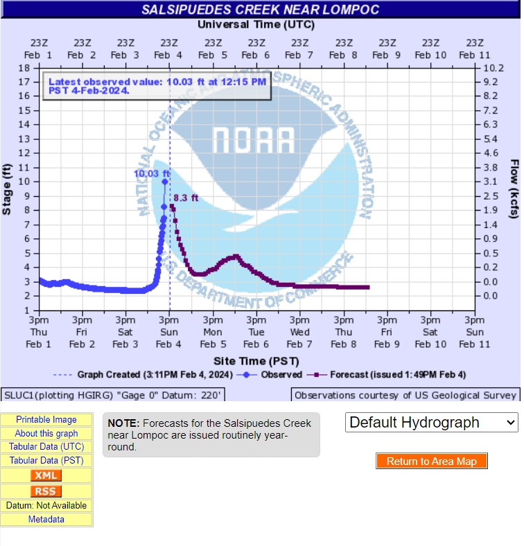
Salsipuedes Creek near Lompoc is exceeding forecast by about 2 ft, so far.
Santa Ynez River at H Street

Probably going to have problems at Arroyo Grande Creek in SLU, but the gages aren’t showing a huge amount of water upstream, so far. Might be some delayed effect at some locations.
1 Like
Of course, Reed Timmer is on the 154.
2 Likes
Im cracking up watching this guy
2 Likes
Reed’s declared the kingdom. We’re in for it now. We got any Corpsmembers left? 500, they said, right? That’s, like, 30+ crews. Big storm, but, I’m thinking we still got a pretty deep bench. Gotta respect the CalTrans. 
1 Like
1 Like
IDK, pretty much Act 1 in the can, maybe. My impression is that the next turning point is whether, and for how long, the storm stalls out over the Transverse and LA, then, perhaps where it goes from there.
3 Likes
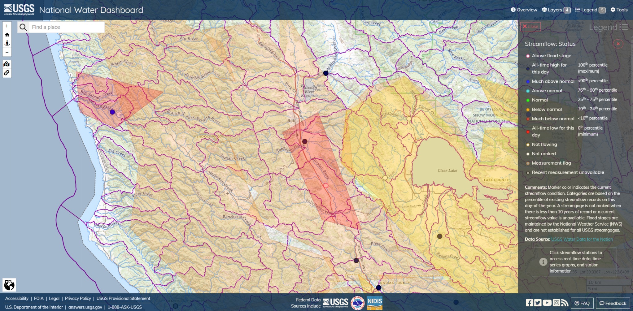
Navarro River and Russian River. CCC Ukiah Center is right in that, off Talmage Road. Ukiah Center is closing soon, IIRC, and the crews will take the new facilities at the Mendocino Center at Willits, north of Lake Mendocino.
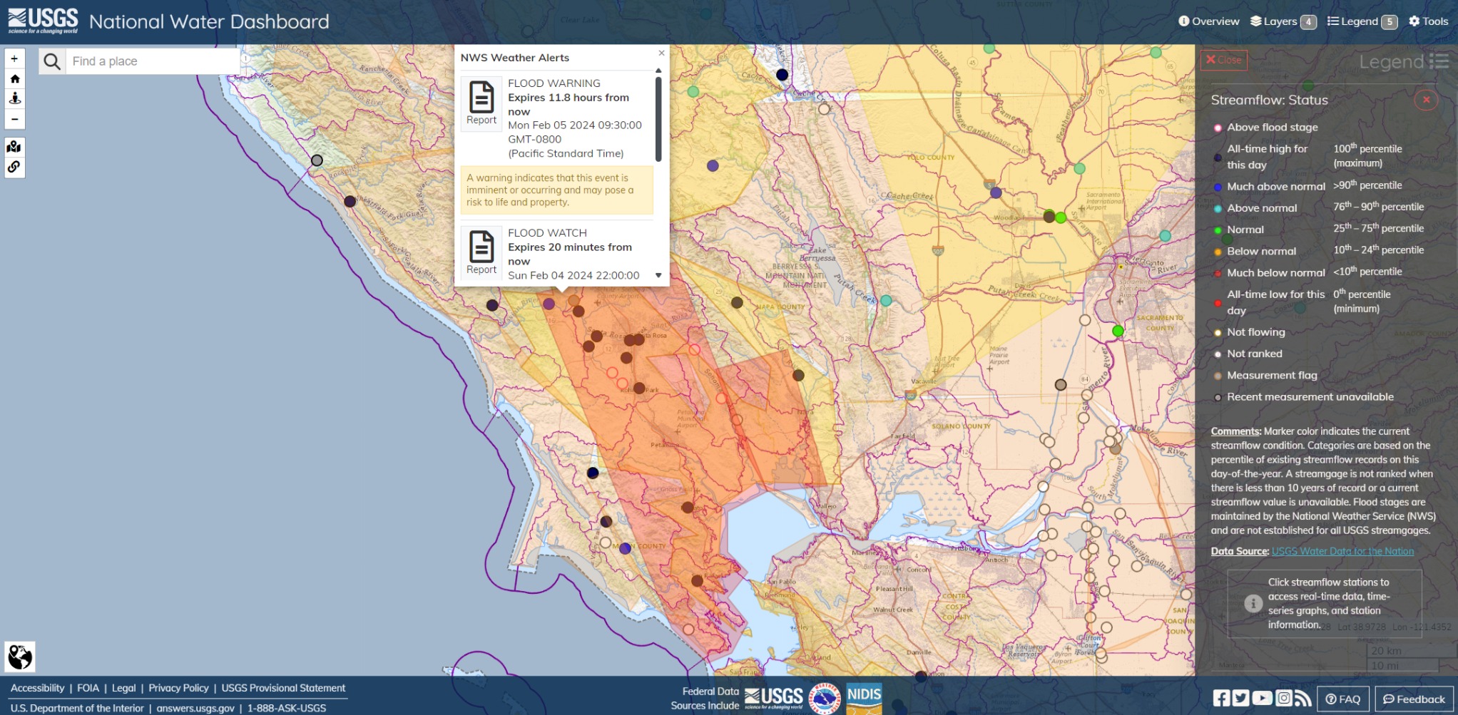
Still looks rough up in the North Bay Area. Big cluster of gages in flood stage or close to it. I haven’t been monitoring any scanners up there, so I have no idea what the pace or urgency is like. Look at it, though. Saturated.

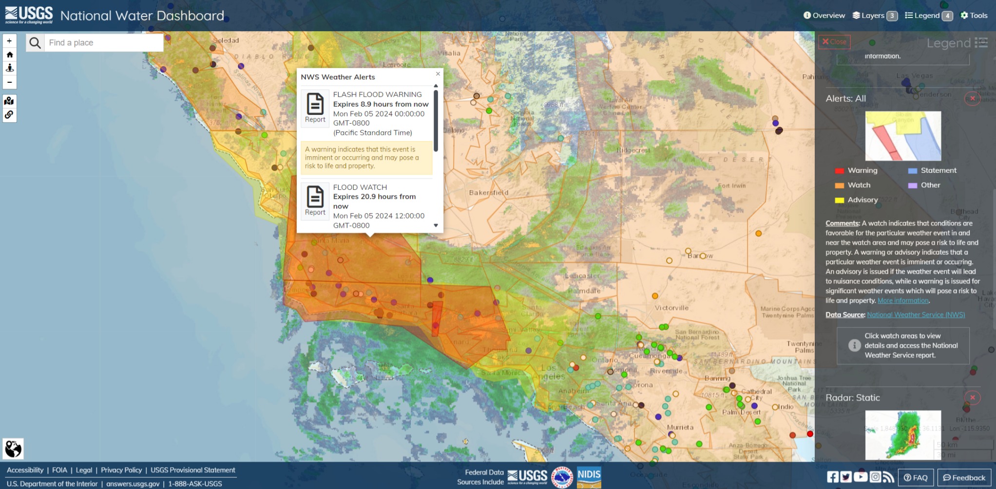
Flash Flood Warning for SLU, Cuyama and the Sierra Madre Mountains is set to return to Watch status, tonight. 3-Day forecast for this area is about an inch.
4 Likes
1 Like