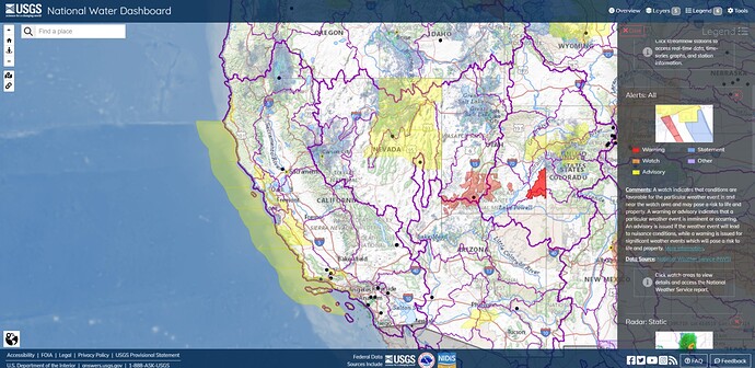
Summary:
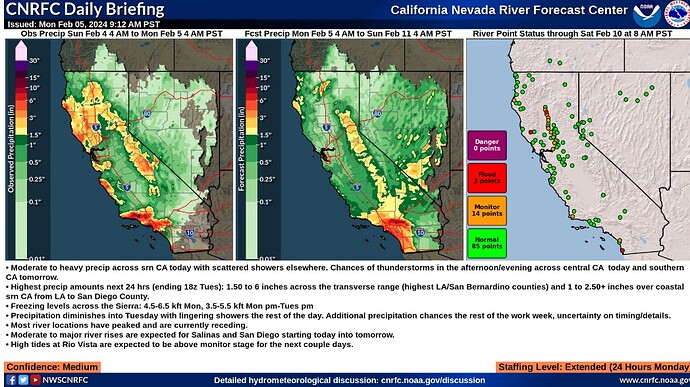
- Moderate to heavy precip across srn CA today with scattered showers elsewhere. Chances of thunderstorms in the afternoon/evening across central CA today and southern CA tomorrow.
- Highest precip amounts next 24 hrs (ending 18z Tues): 1.50 to 6 inches across the transverse range (highest LA/San Bernardino counties) and 1 to 2.50+ inches over coastal srn CA from LA to San Diego County.
- Freezing levels across the Sierra: 4.5-6.5 kft Mon, 3.5-5.5 kft Mon pm-Tues pm
- Precipitation diminishes into Tuesday with lingering showers the rest of the day. Additional precipitation chances the rest of the work week, uncertainty on timing/details.
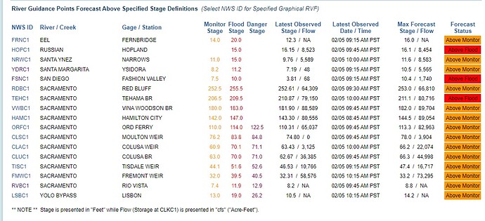
- Most river locations have peaked and are currently receding.
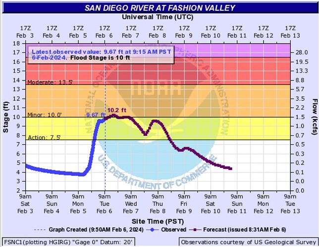
- Moderate to major river rises are expected for Salinas and San Diego starting today into tomorrow.
- High tides at Rio Vista are expected to be above monitor stage for the next couple days.
Confidence: Medium
Staffing Level: Extended (24 Hours Monday)
Detailed Hydrometeorological Discussion: cnrfc.noaa.gov/discussion
Summary:
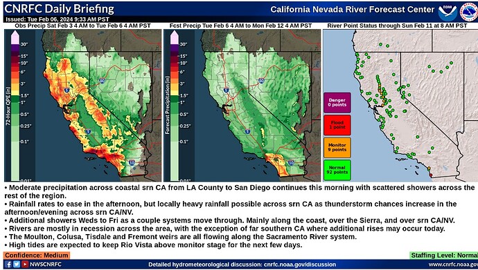
- Moderate precipitation across coastal srn CA from LA County to San Diego continues this morning with scattered showers across the rest of the region.
- Rainfall rates to ease in the afternoon, but locally heavy rainfall possible across srn CA as thunderstorm chances increase in the afternoon/evening across srn CA/NV.
- Additional showers Weds to Fri as a couple systems move through. Mainly along the coast, over the Sierra, and over srn CA/NV.
- Rivers are mostly in recession across the area, with the exception of far southern CA where additional rises may occur today.
- The Moulton, Colusa, Tisdale and Fremont weirs are all flowing along the Sacramento River system.
- High tides are expected to keep Rio Vista above monitor stage for the next few days.
Confidence: Medium
Staffing Level: Normal
Detailed Hydrometeorological Discussion: cnrfc.noaa.gov/discussion
Watch Tow-Happy Californians Street Surf During Severe Flooding in Ventura County - Surfer
Looks like fun, and its a little bit of a morale boost, but, the bottom line is that you don’t really want to go play in flood waters. I doubt this water is as toxic as is found in more severe and destructive disasters, but I caught an infection within a week of settling in at the site in New Orleans. Like many other arrivals, I was soon standing in line at a med tent for my sheet of Zithromax. Try to limit your exposure as much as possible. First responders should be ready to report symptoms of infection by dirty water immediately to help identify potential toxicity.
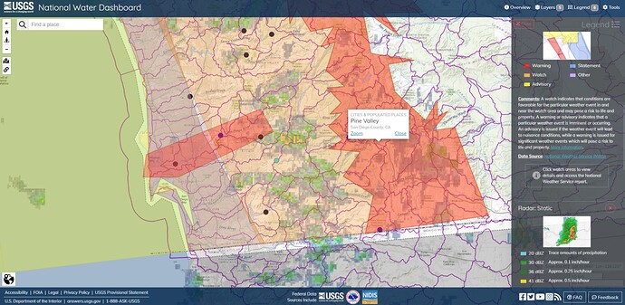
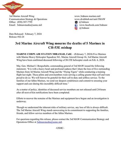
All hands effort underway to get access to a downed USMC CH-53E Super Stallion in the Pine Valley area of San Diego County, five aboard. A Winter Storm Warning is over the area. SDU uploaded a phone cam clip from a staging area.
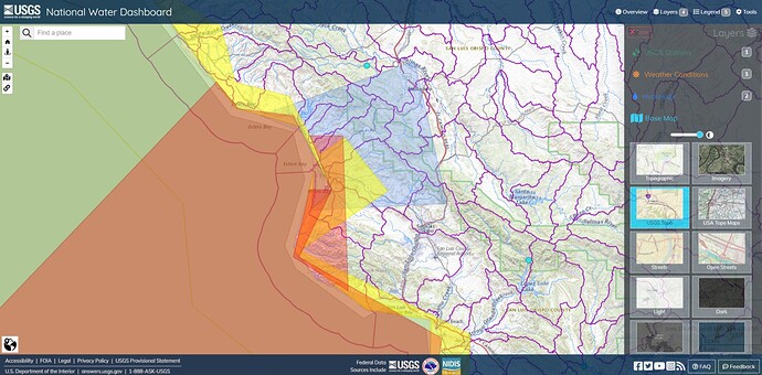
Tornado Warning issued February 7 at 3:37PM PST until February 7 at 4:15PM PST by NWS Los Angeles/Oxnard CA
TORLOXThe National Weather Service in OXNARD has issued a
Tornado Warning for…
Coastal San Luis Obispo County in southwestern California…Until 415 PM PST.
At 336 PM PST, severe thunderstorms capable of producing a tornado
were located along a line extending from Morro Bay to 14 miles
southwest of San Luis Obispo, moving east at 55 mph.HAZARD…Tornado.
SOURCE…Radar indicated rotation.
IMPACT…Flying debris will be dangerous to those caught without
shelter. Mobile homes will be damaged or destroyed.
Damage to roofs, windows, and vehicles will occur. Tree
damage is likely.
- Locations impacted include…
Morro Bay…
Diablo Canyon…
Baywood-Los Osos…
and Cayucos.Instructions
TAKE COVER NOW! Move to a basement or an interior room on the lowest
floor of a sturdy building. Avoid windows. If you are outdoors, in a
mobile home, or in a vehicle, move to the closest substantial shelter
and protect yourself from flying debris.
These tornado warnings are transitory and contingent. Check current conditions.
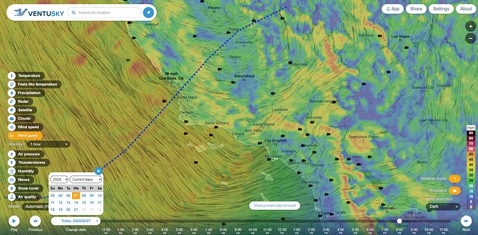
Ventusky HRRR Wind Forecast WED Feb 7 8:00PM PT
Squall line passing to the southeast at 60 mph tonight.
Observations of this weather front by Daniel Swain from Weather West (YouTube, 48m)
NWS:
Public Information Statement
National Weather Service Los Angeles/Oxnard CA
640 PM PST Wed Feb 7 2024…PROBABLE TORNADO IN THE GROVER BEACH/PISMO BEACH AREA TODAY…
A broken line of convective showers developed over the San Luis
Obispo County coastal waters this afternoon, associated with a low
pressure system quickly moving south along the California Coast.
This line of convective showers continued to move onshore around 4PM
this afternoon, bringing moderate to briefly heavy showers, gusty
winds and hail. Radar data and surface observations indicated
isolated wind gusts as high as 60 mph, and the potential for
waterspouts and brief tornadoes given areas of rotation embedded in
the line. The National Weather Service issued Special Weather
Statement to alert the public of the potential hazards associated
with these strong showers, along with a Special Marine Warning for
the coastal waters. A Tornado Warning was also issued for the
coastal area south of Cayucos to near Point San Luis. Multiple
reports of wind damage including downed trees and power poles,
powerlines, and building damage were reported in the Grover Beach
and Pismo Beach area. The National Weather Service in Oxnard, CA is
planning to conduct a damage survey on Thursday, February 8th to
determine if the damage in this area was due to a tornado, or severe
straight-line winds.
Very sad news, RIP to all.
To be clear, I posted this story about the Super Stallion because it appeared to be connected to the storm event. The investigation is not complete and there is no confirmation that the storm was the main cause. Fly safe.
The pilot radioed in both engines dead just prior to the hard landing.
Newtonian Physics, Corner Pocket
A problem with predestination in emergency planning and response is an unwillingness, or inability, to accept uncertainty about outcomes. To use an analogy from pool:
Argument: Predestination states that the game will end with a combination 10-ball in the side pocket.
Rebuttal: You can’t know that, the game is only half finished. What is your evidence?
Argument: The cue-ball hits the 11-ball, which hits the 10-ball, which goes into the side pocket.
Rebuttal: That’s a prediction, not evidence. Besides, the 11-ball is already off the table, it was sunk 5 minutes ago.
Argument: Then, it was the 7-ball.
Rebuttal: That’s the other player’s ball. You can’t use that in a combo.
The issue is about the predicates. Rather than accept the evidential logic of timelines and available resources, predestination is prone to re-introduce unsupported predicates, no matter how implausible, or impossible, those predicates may be. Sometimes, this is ignorance, sometimes, disorderly thinking, sometimes, deliberate attempts to deceive, and it is not always obvious what the underlying issue is.
There are at least three policy consequences that fall out of this, so to speak:
Readiness: the logic and reasoning of what, when and where to preposition resources, even permanent resources like a fire station or air attack base.
Leader’s Intent: the practice of giving tactical leaders flexibility to exercise some initiative to respond to obstacles and opportunities that appear during the execution of a plan. This includes IMT policy that supports and enables tactical leaders by offloading logistical and technical tasks from local responders who probably have better knowledge and experience of the ground and people on the line.
Alert Status: why it is necessary for resources to be alerted to incidents, even if they are likely to be canceled.
Maybe I’m reading too much into your comment about IMTs. But if I’m following you, I agree 100%. When I first got on a CDF ICT 30 years ago they were C&G with a few support ULs. We came in at 30,000’ to ASSIST the Ranger Unit where they needed assistance. Now a IMT comes in and takes over in the weeds. They generally don’t try to blend in until they know how the incident got to where it is and when they wipe their hands and walk out the door they don’t really know what they are leaving. JMTCW
Right. In principle, I’m not sure the image of the IMT as a sort of Arthurian king and noble round table who crusade across the land, slaying dragons, hydras and golems one by one, is a particularly useful one, although there is a factor of the cavalry riding to the rescue, it’s a teams (plural) effort. Not sure about the abbreviations or what turn on them.
Rock, Paper, Scissors, Lizard, Spock Effect (complexity of scope). Under kinetic physical demand and mental stress, we perform better when we don’t have to change zoom levels too much. Responders are more effective when a CB can focus on their section of line, for instance, a Div leader can focus on the scope of their division and an IC can look at the big picture.
Although some leaders can traverse the tiers of scope very well, it’s better when you can stick to a particular scope (zoom level or altitude) as much as possible. Obviously, promotion from within is a benefit when leadership is forced by circumstance to change its scope, as when a Div or Team leader may need to step into a situation due to an IWI.
Naturally, before going off the deep end with tiers, we need to remember that every life is equal in value to every other, even when there is an additive value of how many lives are involved in a particular triage decision.
Maybe, with limited resources, you would evacuate an ICP first to ensure continuity and coherence of the overall fight, and not put strike teams or under-equipped and under-trained support crews in jeopardy needlessly, but that doesn’t mean you would send the whole force into a death trap because an IC decided to run into it by their lonesome.
Always interesting reading, but often I just wish I understood what the hell your saying
