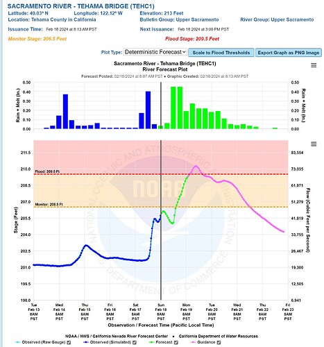
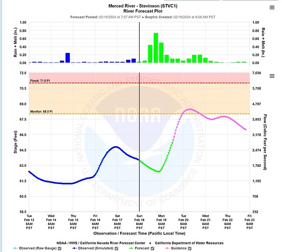
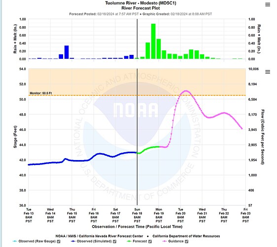
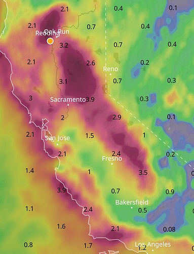
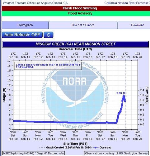
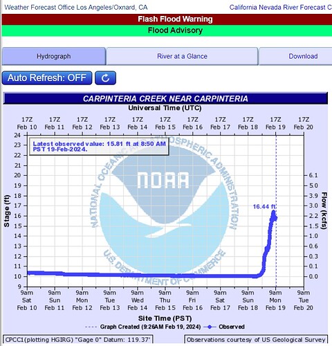
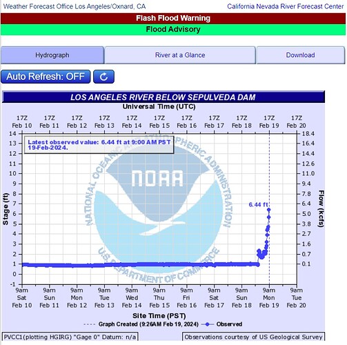
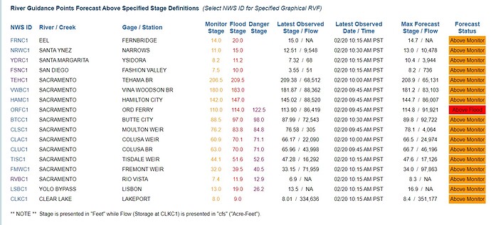
Thank you, I try. Mainly responding to Capt4711 about IMTs and why uncertainty drives many policies and decision points, and rightfully so. Given the hype and misinformation attached to the recent storms, I wanted to check my reasoning against the experience of the readership.
We came in at 30,000’ to ASSIST the Ranger Unit where they needed assistance.
At that time, 30 years ago, I was a Type 2 handcrew tool swamper in the Cs. I’ve heard it called ‘drag spoon’. We mainly envisioned ourselves as backing up Forest Service.
But, even then, CDF seemed to offer a better deal and more financial security, at least to me. This has little or nothing to do with the quality of the Forest Service, and everything to do with Congressional unwillingness to provide financial security to the Federal wildland workforce. And, to be blunt, Cal Fire’s eagerness and willingness to absorb every graduating Corpsmember with a taste for wildland.
Thier argument is very powerful. “We will take care of you.” Trying to encourage Corpsmembers to join the Forest Service these days is like being on the mat with a 500-lb gorilla.
I lay this problem at the feet of the U.S. Congress and the electorate. Maybe, they think they will be better off with a bunch of private under-the-table outfits supervised by the county judges. I think they are wrong in that assumption. They need professional fire chiefs and fire marshals well-versed in all-hazard response. They need the United States Forest Service, the Bureau of Land Management and associated agencies of the NWCG, including ACE Sappers.
Cal Fire and the Counties (and other LG) are looking out for the best interests of individual wildland firefighters at this moment and I’m not picking a fight with it.
This is sort of tangential to the topics of tolerable uncertainty, all-hazard response and flood fighting, but financial security is a needful thing.
As always, riverdogging on wildfireintel.org is an optional/elective topic, and is intended as a support to the main mission.
Summary:
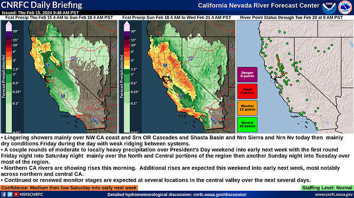
- Lingering showers mainly over NW CA coast and Srn OR Cascades and Shasta Basin and Nrn Sierra and Nrn Nv today then mainly dry conditions Friday during the day with weak ridging between systems.
- A couple rounds of moderate to locally heavy precipitation over President’s Day weekend into early next week with the first round Friday night into Saturday night mainly over the North and Central portions of the region then another Sunday night into Tuesday over most of the region.
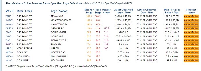
- Northern CA rivers are showing rises this morning. Additional rises are expected this weekend into early next week, most notably across northern and central CA.
- Continued or renewed monitor stages are expected at several locations in the central valley over the next several days.
Confidence: Medium then low Saturday into early next week
Staffing Level: Normal
Detailed Hydrometeorological Discussion: cnrfc.noaa.gov/discussion
Summary:
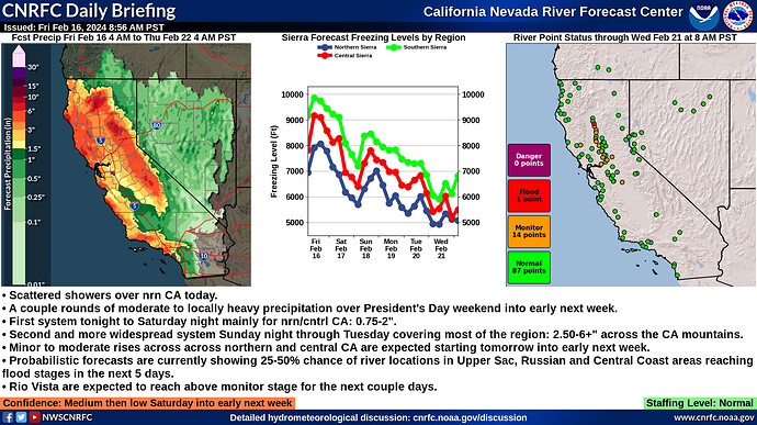
- Scattered showers over nrn CA today.
- A couple rounds of moderate to locally heavy precipitation over President’s Day weekend into early next week.
- First system tonight to Saturday night mainly for nrn/cntrl CA: 0.75-2".
- Second and more widespread system Sunday night through Tuesday covering most of the region: 2.50-6+" across the CA mountains.
- Minor to moderate rises across across northern and central CA are expected starting tomorrow into early next week.
- Probabilistic forecasts are currently showing 25-50% chance of river locations in Upper Sac, Russian and Central Coast areas reaching flood stages in the next 5 days.
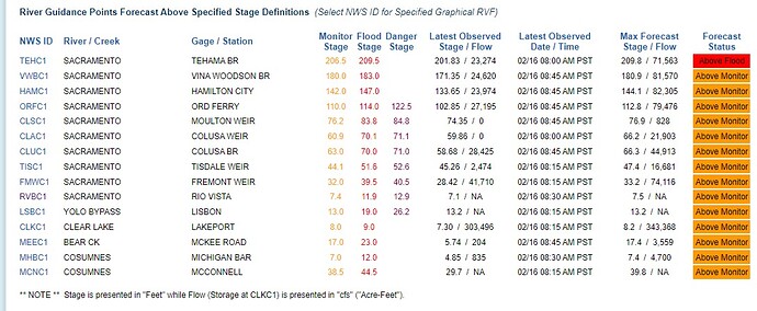
- Rio Vista are expected to reach above monitor stage for the next couple days.
Confidence: Medium then low Saturday into early next week
Staffing Level: Normal
Detailed Hydrometeorological Discussion: cnrfc.noaa.gov/discussion
Note: River Guidance Points Forecast may be subject to change or revision before the publication of the next Daily Briefing.
This is not an official publication, and I am not employed by the agencies, nor am I a public information officer. That said, would you like me to draw you a picture of the central mandate I am talking about?
Swinging for the fences, theoretically, a new joint Swift Water program would not need to be ordered as a Cal Fire resource, as mandated by the CA Mobilization Guide. But, they would still be a resource available to Interagency Ops. CCC crews routinely generate more revenue than cost. Help pay for it by letting Cal Fire and the Counties farm out a little culvert and trail work to the outfits?

To be clear, Corpsmembers need to be supervised by a C1 (aka Federal Crew Boss) and/or appropriate Special Corpsmember (Yellow Hat) supported from the nearest Center. Tahoe Center flies in NDF Helitack helicopters, presumably, a 4 member Ranger Unit SAR could float an 8 or 15 member crew in the water. They bed down in the Federal AOR picked by the FS or BLM rep. If it operates to satisfaction, Centers could provision 10 day spikes to the location for orientation and training, along with the trail work. The moon on a stick, right?
[Example of a 4 member ‘Ranger Unit SAR’: 1 Ranger (or eq. BLM) to host/lead/pick locations and 3 SAR volunteers from the County, or 2 and 2, depending on availability.]
Channels has it they have some extra gear this year.
Summary:
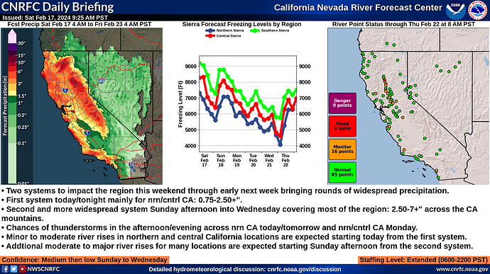
- Two systems to impact the region this weekend through early next week bringing rounds of widespread precipitation.
- First system today/tonight mainly for nrn/cntrl CA: 0.75-2.50+".
- Second and more widespread system Sunday afternoon into Wednesday covering most of the region: 2.50-7+" across the CA mountains.
- Chances of thunderstorms in the afternoon/evening across nrn CA today/tomorrow and nrn/cntrl CA Monday.
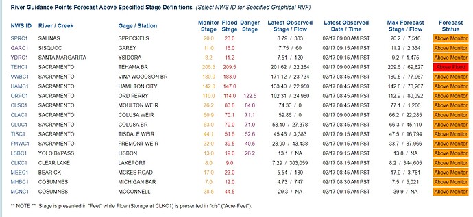
- Minor to moderate river rises in northern and central California locations are expected starting today from the first system.
- Addtional moderate to major river rises for many locations are expected starting Sunday afternoon from the second system.
Confidence: Medium then low Sunday to Wednesday
Staffing Level: Extended (0600-2200 PST)
Detailed Hydrometeorological Discussion: cnrfc.noaa.gov/discussion
Summary:
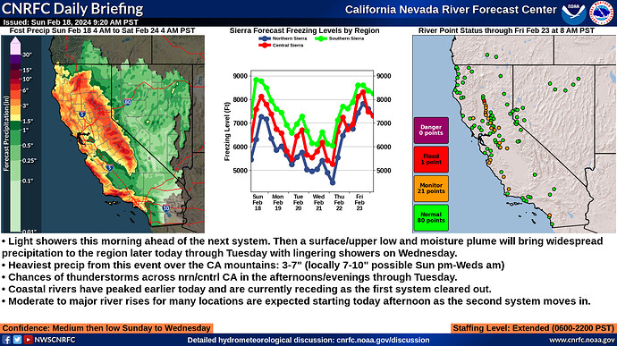
- Light showers this morning ahead of the next system. Then a surface/upper low and moisture plume will bring widespread precipitation to the region later today through Tuesday with lingering showers on Wednesday.
- Heaviest precip from this event over the CA mountains: 3-7" (locally 7-10" possible Sun pm-Weds am)
- Chances of thunderstorms across nrn/cntrl CA in the afternoons/evenings through Tuesday.
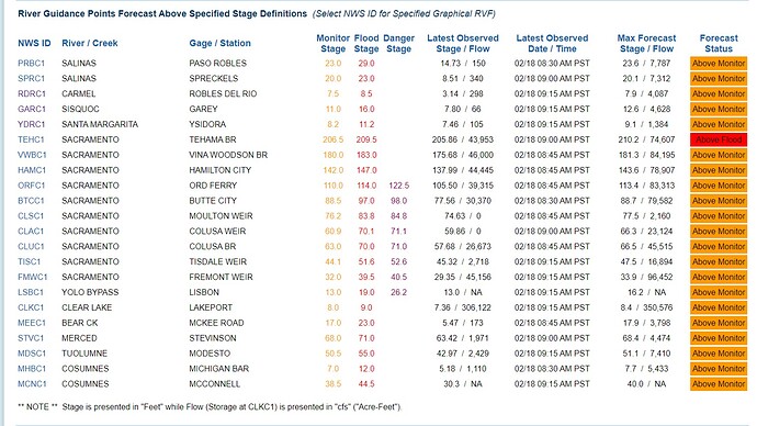
- Coastal rivers have peaked earlier today and are currently receding as the first system cleared out.
- Moderate to major river rises for many locations are expected starting today afternoon as the second system moves in.
Confidence: Medium then low Sunday to Wednesday
Staffing Level: Extended (0600-2200 PST)
Detailed Hydrometeorological Discussion: cnrfc.noaa.gov/discussion
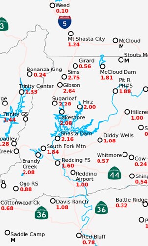
72 hour modeling showing 6"-7" accumulation of precip in 3 regions.
Sierra crest east of Fresno
Cascade crest Butte/plumas
I-5 corridor Redding to Dunsmuir.
So the first 2 could be in the measures of snow based on elevation… But the Redding-Dunsmuir region is too low and will all be in the form of rain!
Models yesterday in that area forcasted 9-10 by weds. Yesterday received 2.75" in 24 hrs, so the 9-10" looks viable by weds. Just some interesting numbers. Forgotten fact … We used to call these winter storms… Or at best a pineapple Express🤣
Just to elaborate a bit on how I envision it happening. FS/BLM rep picks the spot that keeps em up at night. Spike the CCC Crew there. Thats roughly 8 days on the site (2 travel days). 4 or 5 days of improving the site and maybe 2 or 3 days in the water. Obviously, any County SAR volunteers would only need to drive out to the site for the swift water orientation days.
This storm will be interesting to say the least. Only got .30" but the wind was off the hook. This was in the Sonora area. Steady south wind blowing here on the ridge I live on. 10-15 with gust to 30 at times.
Lots of yellow and red on the extended radar coming into Calif. 61 out pretty much sunny with a few clouds for now.
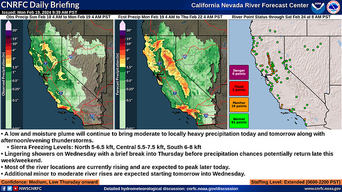
Summary:
- A low and moisture plume will continue to bring moderate to locally heavy precipitation today and tomorrow along with afternoon/evening thunderstorms.
- Sierra Freezing Levels: North 5-6.5 kft, Central 5.5-7.5 kft, South 6-8 kft
- Lingering showers on Wednesday with a brief break into Thursday before precipitation chances potentially return late this week/weekend.
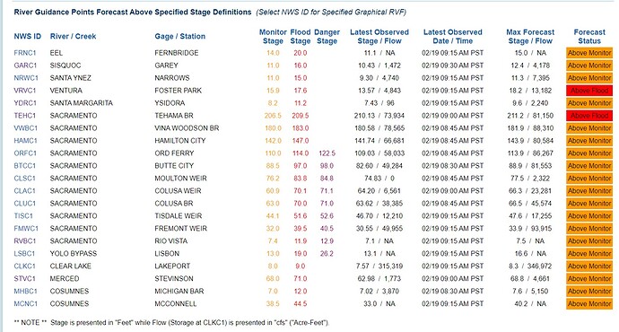
- Most of the river locations are currently rising and are expected to peak later today.
- Additional minor to moderate river rises are expected starting tomorrow into Wednesday.
Confidence: Medium, Low Thursday onward
Staffing Level: Extended (0600-2200 PST)
Detailed Hydrometeorological Discussion: cnrfc.noaa.gov/discussion
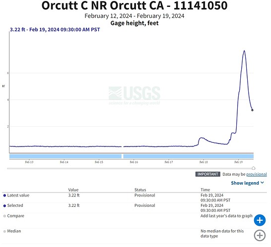
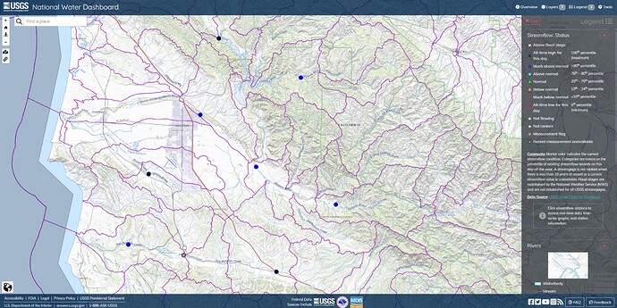
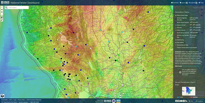
Santa Barbara North County
Orcutt Creek
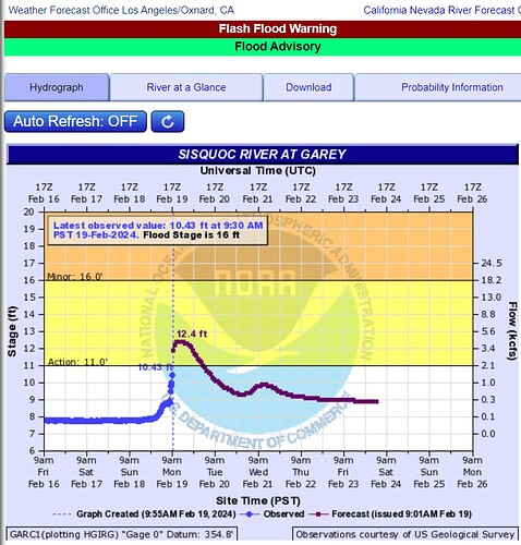
Sisquoc River
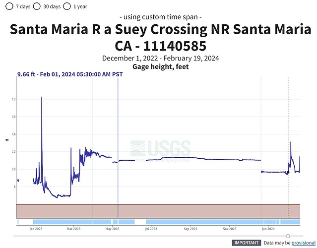
Santa Maria River got in trouble last year when Twitchell Reservoir went into overflow and the Cuyama and Sisquoc Rivers overwhelmed the buffer northeast of the City of Santa Maria. Orcutt Creek piled in to flood areas around the dunes. Doesn’t look nearly that bad right now.
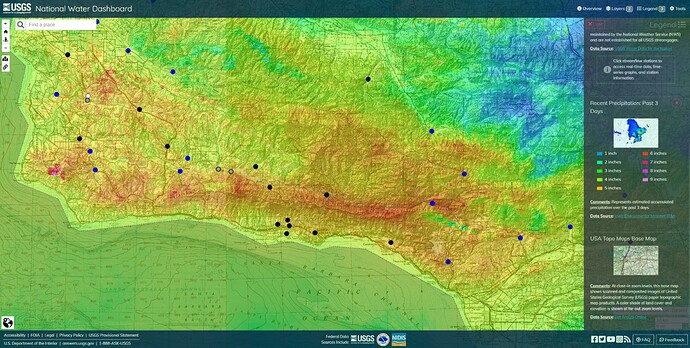
2/19/24 1130AM PT Past 3 Days Cumulative
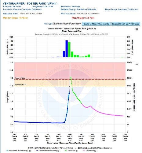
Santa Barbara, Ventura and west LA.
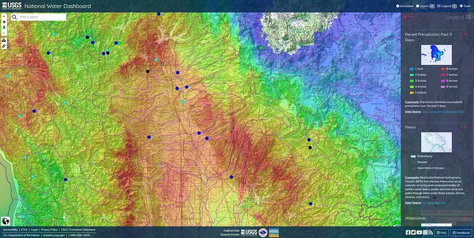
Laguna de Santa Rosa in Sonoma County triggered a brief Flash Flood last night. Looks like the majority of the past 3 days fell east of Clear Lake.
Sacramento River and surroundings. 2/19/24 1200PM PT Past 3 Days Precip
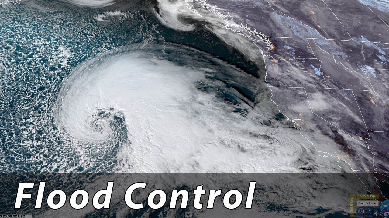
Last year, @pyrogeography talked about Flood Control on the Sacramento River. (YouTube, 53min)
We take a tour of Northern California, talking about levees, weirs, bypasses, pumps, rain on snow, dam releases, fish, irrigation, dams, and the big picture of water management on the Sacramento River.
I remember these conversations back in the 70’s. Since then a lot of bloviating, but action has been primarily as reaction . Unless you want to count the dams that have been REMOVED, not built.
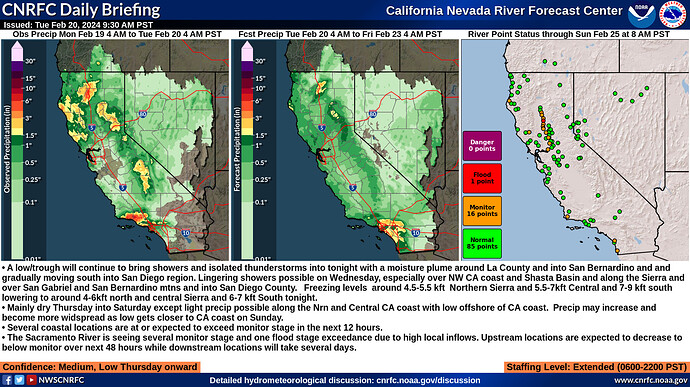
Summary:
- A low/trough will continue to bring showers and isolated thunderstorms into tonight with a moisture plume around La County and into San Bernardino and and gradually moving south into San Diego region. Lingering showers possible on Wednesday, especially over NW CA coast and Shasta Basin and along the Sierra and over San Gabriel and San Bernardino mtns and into San Diego County. Freezing levels around 4.5-5.5 kft Northern Sierra and 5.5-7kft Central and 7-9 kft south lowering to around 4-6kft north and central Sierra and 6-7 kft South tonight.
- Mainly dry Thursday into Saturday except light precip possible along the Nrn and Central CA coast with low offshore of CA coast. Precip may increase and become more widspread as low gets closer to CA coast on Sunday.
- Several coastal locations are at or expected to exceed monitor stage in the next 12 hours.
- The Sacramento River is seeing several monitor stage and one flood stage exceedance due to high local inflows. Upstream locations are expected to decrease to below monitor over next 48 hours while downstream locations will take several days.
