@Ehoss84 thats basically here but very rough around the edges in deployment. But thats a training environment. AR can certainly be used in real life events to enhance understanding. The military has tried it with ivas but it has a time and place to be used.
On the line though is what we have now good enough but just not used? Does TAK answer the mail? Does Avenza? Does Field maps? Whats missing?
Working for the “Big Red Army” we have access to T.A. with both On-Line and Off-Line functionality when coupled with the roll out of AVL 2.0(2024) and AVL 3.0(2025-2027) and eventual Satellite connectivity, the connections willbe almost seemless.
Additionally a form of (blue force tracking) with KeyFobs talking back to the AVL unit the KeyFob is assigned to responding unit. The SA for IC’s has the potential to overload the decision makers.
Finally, having access to current SA tools (CHP CAD Accident Data, Mesonet Weather data, Alert Wildfire cameras) on engine tablets. The Company Officer in charge, given the necessary time to use (time over distance while responding) to protect the responding crew.
Things like Tablet Command have become a game changer.
What most people fail to realize is the Historical aspects of the job. Marble Cone, Kirk, Basin, Soberanes fires all burned the same area/foot print. Yet ask a FF today what these fires have in common, and your lucky to get a FF that knows about the Soberanes fire and the fatality that occurred. The IPhone isn’t even 20yr old and look how far, how fast we have come.
What I have found that works is engagement at the Breakfast/Dinner table. Thought provoking discussions like this thread, but in person over a meal in a crew environment has paid divideds of engagement, questions and discussion.
I agree with you. I think the existing tech has more than enough capability to help us understand what is happening, using/adopting/proficiency is our biggest issue imho.
As far as being overwhelmed on a screen yup you have to “turn off” layers that are not relevant to what your currently doing. I see this a lot, i grab a tak tablet and its a bloody mess of polygons, map outlines etc.
You mentioned "tablet command being a game changer. Im assuming your talking about the incident management portion of that, ie being able to have essentially a live IAP/204s. Could you elaborate?
Last but not least, cell from space will change the landscape with connectivity. Not having to carry an additional hardware solution to communciate through will lower the barrier.
The accountability aspect of TC with agencies populated into the incident for IC’s to manage, see in real time. Then the layers, upon layers, upon layers🤣. Yup I keep exactly 3 turned on over a Hybrid Topo. Jurisdiction FRA-LRA-SRA & MTZ.
Having the pre-populated “list” for what kind of incident that is pushed from CAD from notifications to PAR clocks to utilities.
The IAP in real-time for assignments. TC doesn’t take the place of a good paper management cycle. But using the steno “Tablet” is now just notes once you get comfortable with the program. Seeing all the responding resources, regardless of agency, especially with all the CAD 2 CAD interface gives a level of SA on multi Jurstictionional, unified command incidents.
I know not every agency is using it. But those that are has freed up precious airtime when a dispatcher is getting beat up and voiceless commands can be used.
FLIR ONE has a few interesting thermal imaging accessories. USB-C. Should fit to a Samsung Galaxy, IPad or phone. That might leave your hand free, where a handheld ‘gun’ type imager would need another answer. Another problem with a separate hand-held is the connectivity can be sketchy. Bluetooth has huge latency and is easily jammed by traffic. A long cable is cumbersome. I like the clip-on pen flir, if the pen could be secured to something, like a helmet, visor or earcovers.
Probably not going to get around the requirement for a serious crew imager to see at 1000+ degrees and the consequent increase in price over a 200 dollar consumer item. I think the ability to read the regular camera over the thermal image is intriguing. This could be useful for mop up or low-heat search? IDK.
Hey all, we’ve been working a lot of suggestions that I received here into the fire.ca.gov incident site. We recently launched a new flight tracking layer and a historic perimeter layer. Today we launched a new automation process that hooks our incident DB directly in with IRWIN and FIRIS. This should mean incidents over 10 acres should be getting on the board in near real-time, along with real-time FIRIS acreage and perimeter updates. Keep an eye on our site this season and let me know what other areas we could continue to improve on.
Come work with us at Deer Creek Resources!
We are hiring a GIS Operations Manager to oversee our mapping operations and supervise our onsite wildfire response mapping assets. This position is an opportunity to help lead one of America’s best-established wildfire mapping/technology companies. We are not a startup, and we’re not selling any snake oil.
This position is based in Chico, California.
Read the full announcement here: Employment at Deer Creek – Deer Creek Resources
Hey all. The Firescope white paper on Firefighter tracking was published. I help craft this document as more of a guidance document when looking at solutions. There are plenty of existing solutions available today. If your shopping for one take a look through the lens of this document.
After a couple years of back channel talks an open to the public TAK event is happening this fall in the DC area. This will be a great event if your interested in learning more about TAK for your agency, networking with users and vendors in this space.
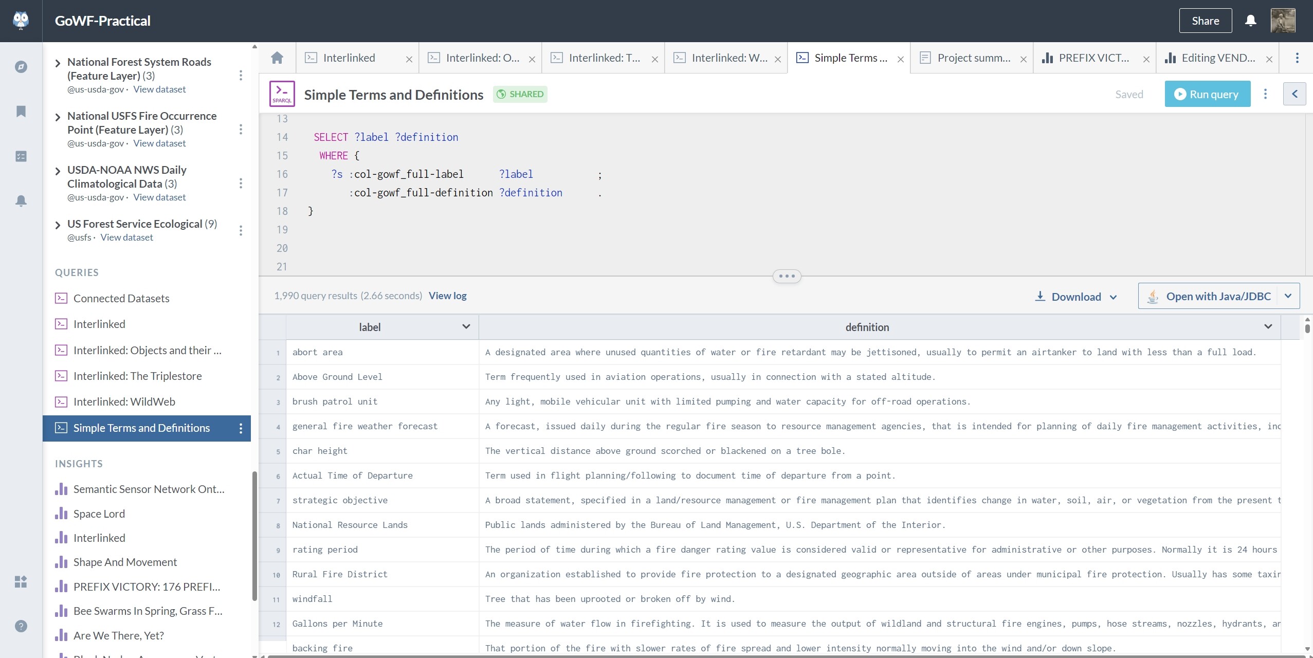
NWCG Glossary Of Wildland Fire, PMS 205 has been updated and now requires a Login.gov account, although its available to the public and didn’t want more than an email and a text message or authenticator app.
If you recall, last year, I presented a (quite) casual tutorial of the EDG and related topics and technologies on data.world, including; a bare snapshot of PMS 205 (with a patch to resolve a specific Top Braid proprietary language issue), REST, RDF and JSON fundamentals, and a custom editing environment prepackaged with exploration and data mining tools for integrating unofficial copies of PMS 205 with a variety of datagraph stores and tools, including; TAK servers, Inciweb RSS, UCSB’s KnowWhereGraph, Openlink Virtuoso and my own favorites (lisps), Emacs and Franz’s Allegrograph.
I also shed a little light on some of the pros and cons of various technical decisions made in the construction of datagraph systems, ontologies and schema. If you would like access to that material, let me know, but I’d rather not offer it broadly to the public, per se, until its reviewed and updated for content and license.
That said, I’m sure the current state of PMS 205’s EDG implementation is better than ever.
'Kay. Pretty sure its all compliant for vendors. The TAK Server of reference is documented, open source and is used by some of the apps in AJs material. REST security and other features demonstrated in the guide should be appropriately handled by official providers observing all appropriate law.
I encourage you to make an account and reap the vast amount of graph that is generated and consumed via data.world, but particularly the terms and structure that NWCG, the rank and file, and Top Braid have decided best represents the intentions of the leadership.
This project is a series of 17 Insights, in no particular sequence, each featuring a rough collection and examination of factors considered by NWCG when selecting among choices of iron work that holds the knowledge graph together.
Six custom coded Queries against EDG’s interface, UCSB’s OntoText iron work and a range of standard compliant apps demonstrate tasks.
I don’t represent or am employed by any vendor features or discussed, all opinions are my own and I don’t promise anything actually works or is fit for duty.
The dataset of interest is NWCG PMS 205 Glossary of Wildland Fire, in two forms, appendix, and knowledge graph, currently hosted in a Top Braid EDG server infrastructure. This project documents the DOI SERVICE and hosts a non-official dated snapshot in three files; gowf.json, gowf-full.csv, and gowf.ttl. In principle, all named IRI should resolve within the scope of the Practical. URLs generated by SERVICE providers may change without notice.