
This event is shaping up to potentially be very unique and have wide spread effects on the Fire Community and existing Incidents. Carry on discussion here.
Hurricane acumen is on the lower side… but wondering the effect of it ingesting all that dry air once it makes landfall. If that would be the case the storm will lose circulation and could slow down? Right now the GFS is spitting out some prolific precip amounts. Significant risk for severe weather as well which would exacerbate precip amounts. When you add orthographic effects of the inland empire and the mountains in Sand Diego and Imperial counties could be a significant event for those areas.
8 Likes
What kind of numbers are being tossed around such as rain amounts and wind speeds?
2 Likes
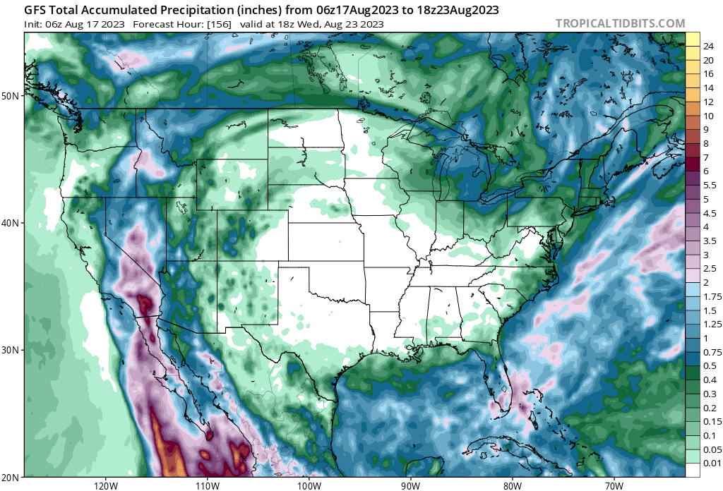
5 inches across the lower elevations and maybe twice that on the slopes. Wind speeds will diminish as the storm moves inland. I am guessing you might see some strong winds once it nears the coast- maybe TS force so sub 70 mph- but that will be short lived. The loss of fuel and the terrain will tear it apart. But the thunderstorm potential will be present for several days.
8 Likes
The storm will be under baroclinic influences and transitioning into a subtropical storm so I don’t think it will slow down or stall or anything like that. We don’t really have much reference for this kind of set up here obviously so it is possible we get a landfalling tropical storm that still meets the criteria even if it is a subtropical storm. I’m sure NHC will be under pressure because a landfalling tropical storm would be a huge ‘selling’ point, but it really doesn’t matter if it is tropical or subtropical because the effects should be the same.
https://twitter.com/RyanMaue/status/1692146297086554294
9:23 am update: the storm is around category 4 status already per dvorak satellite estimates.
9 Likes
Thank you both!
2 Likes
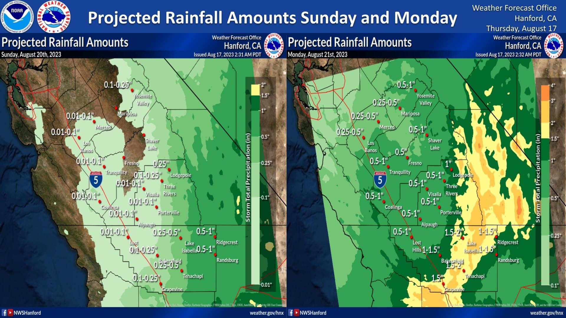
How far north are they expecting the heavy rains? Tulare County has not recovered from this winter. This is the time of year when they start laying grapes on trays Bakesrfield north. Not to mention other row crops that could be effected. This sounds like it could cause some major flooding issue in SoCal.
3 Likes
NWS is having a webinar today at 2:
Tropical Cyclone Hilary rain and wind impacts to Southern California update #3 on Aug 17, 2023 2:00 PM PDT at:
https://attendee.gotowebinar.com/register/2152583616154729301
5 Likes
Many of the dams are fairly full, so a large influx of rain into central California could put areas back into flood stages.
5 Likes
CNRFC is not currently projecting any stations hitting flood. Additionally, many of the reservoirs in the path of Hilary look to have a fair bit of capacity and not releasing much compared to March.
CNRFC River forecast plots:
CNRFC - California Nevada River Forecast Center (noaa.gov)
Reservoir info:
CDEC: RES (ca.gov)
LADWP: Reservoir Overview Operations Report (ladwp.com)
3 Likes
I did some quick guesstimate math, based on watershed and predicted rain amounts for one dam. It should have the needed space, but will be close to 95-100% full. Any deviation to the amounts though could push things higher and back into flood release.
5 Likes
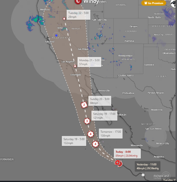
Hilary has undergone bombogenesis…rapid intensification. Since 2am PST she has increased winds from 70mph to 105mph and pressure has dropped from 988mb to 965mb. Far surpassing the 24 hr requirement for rapid intensification and occurring in only 9 hours!
Born and raised here…all is SD county and this is historic for the last almost 100 years if happens as forecast.
SUMMARY OF 300 AM MDT…0900 UTC…INFORMATION
LOCATION…14.6N 106.3W
ABOUT 330 MI…535 KM SSW OF MANZANILLO MEXICO
ABOUT 620 MI…995 KM SSE OF CABO SAN LUCAS MEXICO
MAXIMUM SUSTAINED WINDS…70 MPH…110 KM/H
PRESENT MOVEMENT…WNW OR 300 DEGREES AT 13 MPH…20 KM/H
MINIMUM CENTRAL PRESSURE…988 MB…29.18 INCHES
BULLETIN
Hurricane Hilary Intermediate Advisory Number 5A
NWS National Hurricane Center Miami FL EP092023
1200 PM MDT Thu Aug 17 2023
…HILARY NOW A CATEGORY 2 HURRICANE…
…LIKELY TO BECOME A MAJOR HURRICANE LATER TODAY…
SUMMARY OF 1200 PM MDT…1800 UTC…INFORMATION
LOCATION…15.8N 108.4W
ABOUT 500 MI…805 KM SSE OF CABO SAN LUCAS MEXICO
MAXIMUM SUSTAINED WINDS…105 MPH…165 KM/H
PRESENT MOVEMENT…WNW OR 300 DEGREES AT 14 MPH…22 KM/H
MINIMUM CENTRAL PRESSURE…965 MB…28.50 INCHES
13 Likes
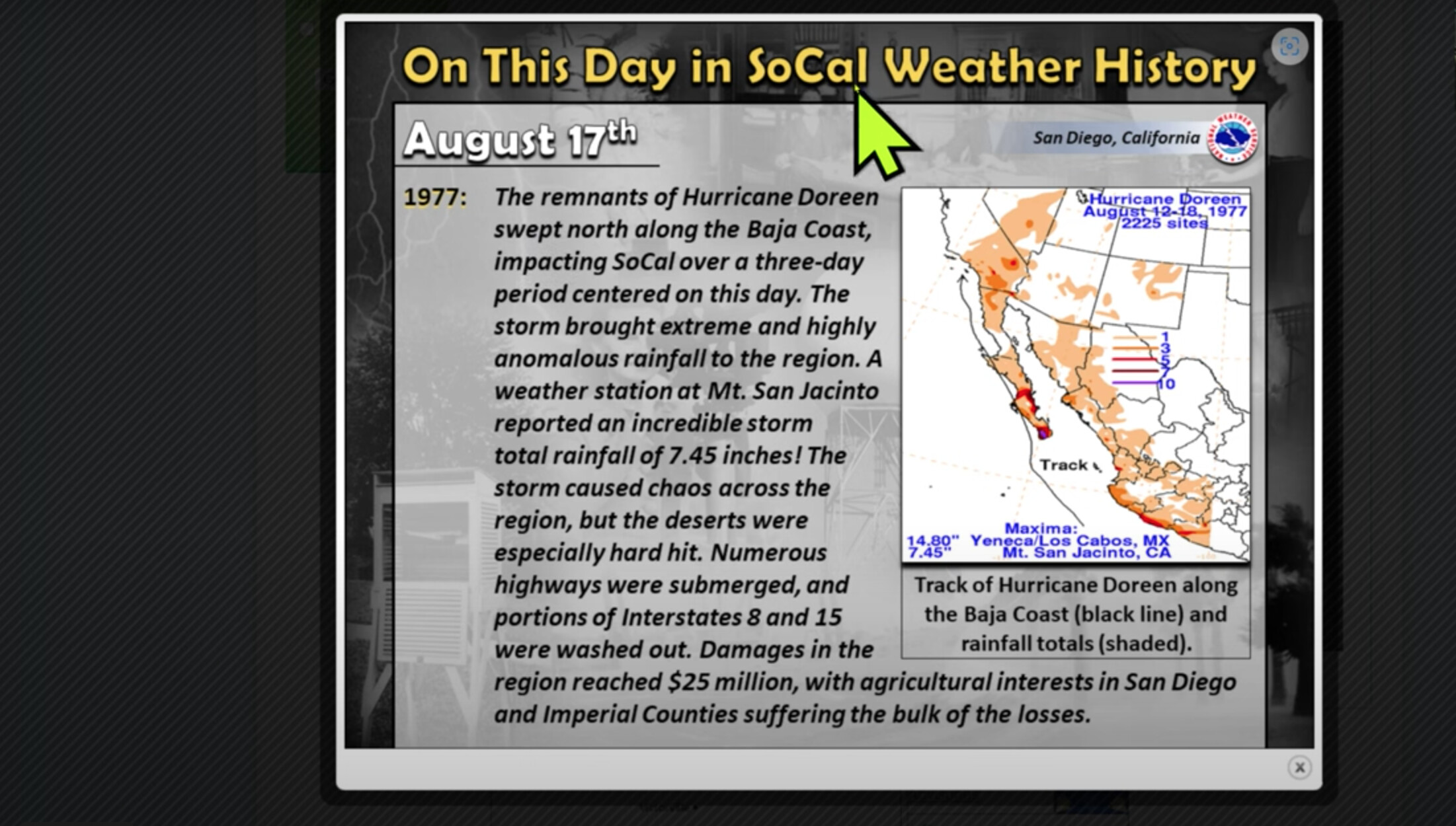
The other impact of that 77 storm was Marble Cone MtDiablo Pondosa and Scare Face fires
10 Likes
The hurricane models on the 18z run initialized the storm 7-11 MB weaker than it is and still the HFAS-B peaks the storm at 946 MB in 48 hours, so it is feasible that the storm deepens to around 930-940 MB at maximum intensity.
4 Likes
love this thread, learning so much. is the category of a storm dependant on the mb dropping? or other factors as well?
Not sure if this question would be more suited for NOPS Weather, but what impact, if any, will Hillary have on the evolving lightning fires in the North of the state? From what I can tell, not much precip making it that far. Winds? Thanks for the intel!
2 Likes