@anvilhead and @pyrogeography, I appreciate all the posts and perspectives. I’ve learned a lot just reading your commentaries. 
14 Likes
2 Likes
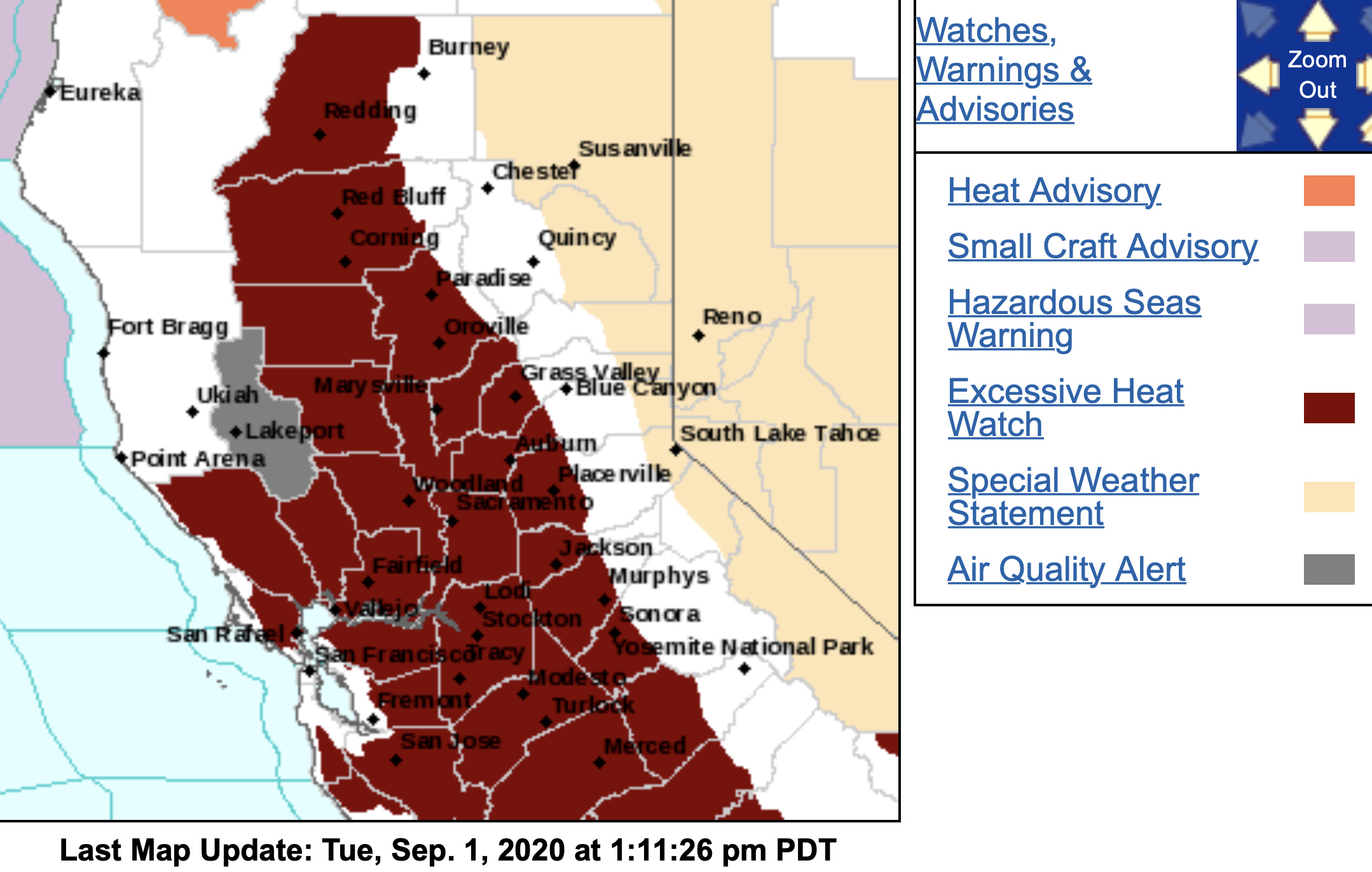
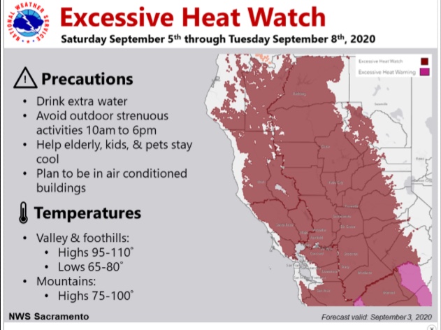
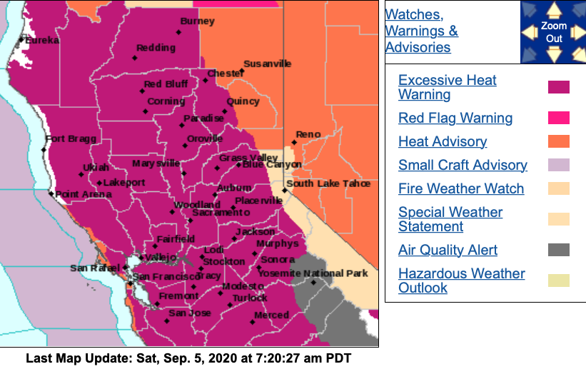
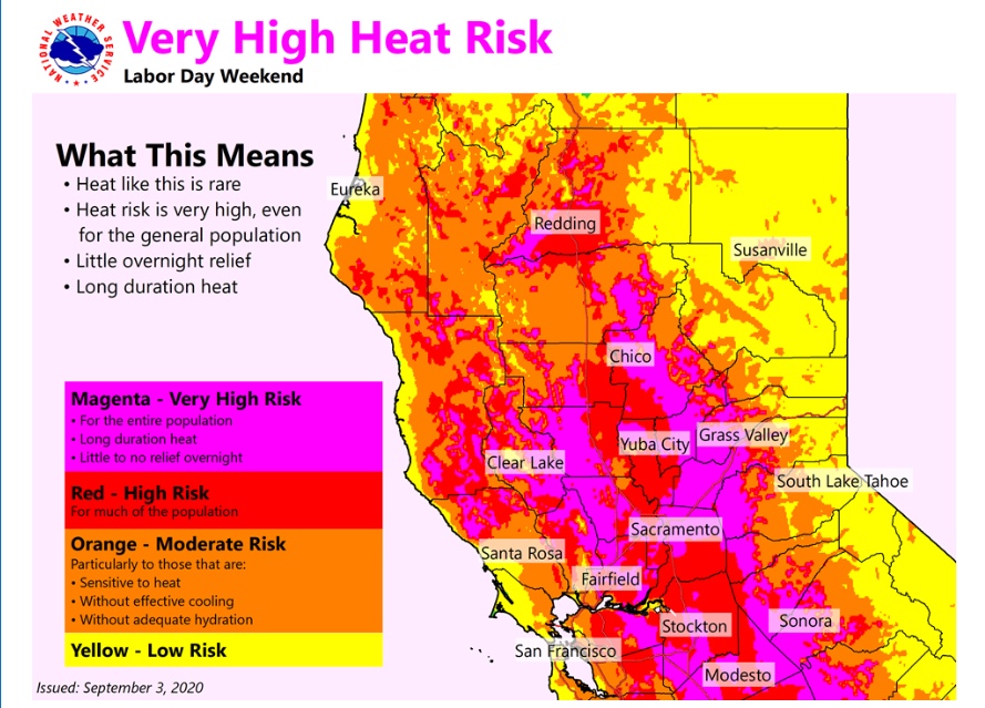
NWS SF:
…EXCESSIVE HEAT WATCH IN EFFECT FROM SATURDAY MORNING THROUGH
MONDAY EVENING…
-
WHAT…Well above normal temperatures with afternoon highs in
the mid 90s to 108. -
WHERE…Interior San Francisco Bay Area, Interior Central Coast.
-
WHEN…From Saturday morning through Monday evening.
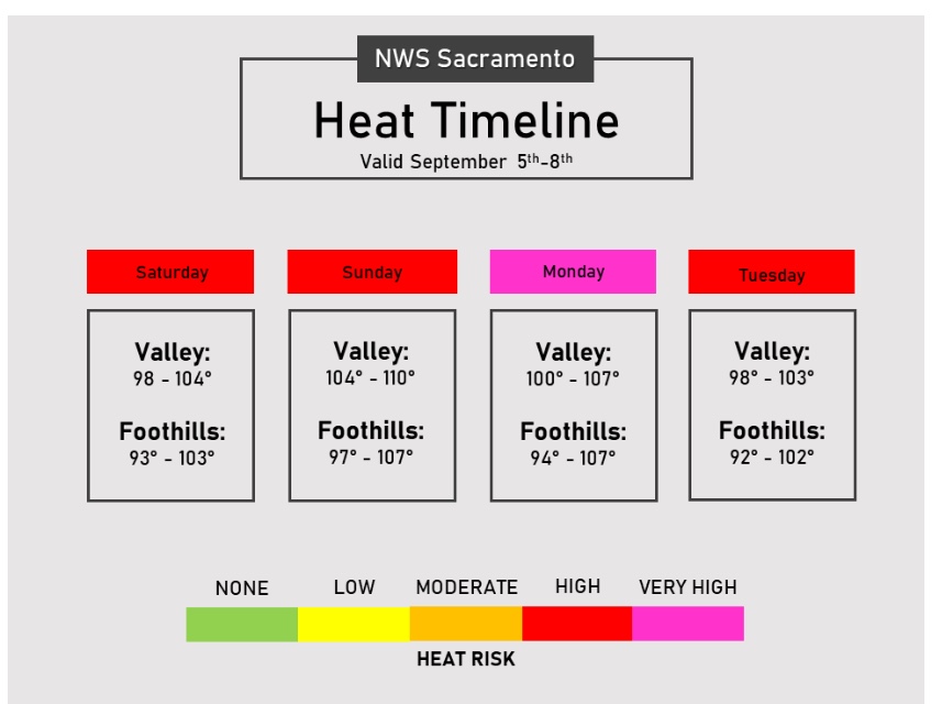
NWS Sac:
WHAT…Dangerously hot conditions with afternoon highs 100 to
110 for the Valley, and 95 to 105 for the foothills. Overnight
lows in the mid to upper 60s to around 80.
-
WHERE…Central Valley, Delta, foothills, and mountains
southwestern of Shasta County to western Colusa County. -
WHEN…From Saturday morning through Tuesday afternoon.

2 Likes
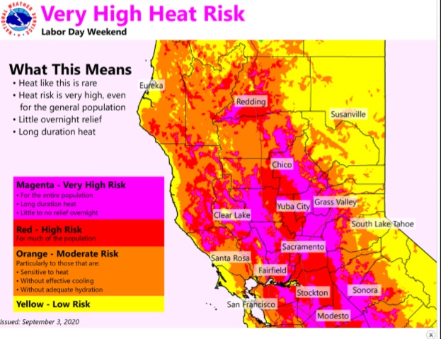
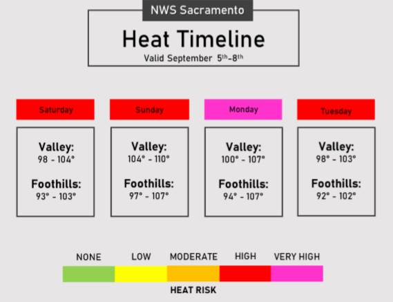

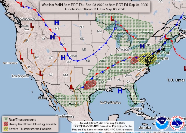
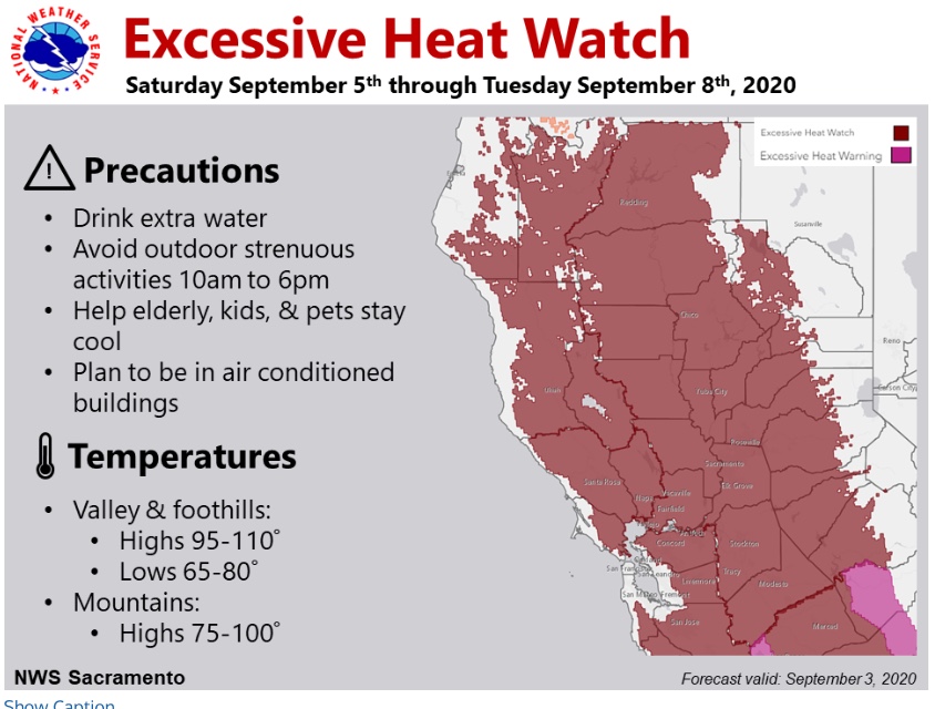
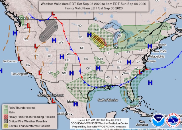
This applies to both North Ops and South Ops: widespread record heat likely this weekend along with weak offshore flow and extremely low humidity. Parts of Central Valley and coastal SoCal will likely break all-time September monthly temperature records and a few spots may even see all-time (any month) records fall. Overnight temperature recoveries will be very poor, especially for a late-season heat event. Much larger uncertainty regarding stronger possible offshore wind event Tues-Wed next week.
3 Likes
Mesocyclone,
Enjoyed hearing you on NPR’s 1A the other day. It is important that people across the country hear a clear voice talking about the combination of climate and human factors that are resulting in more destructive fires across the west.
8 Likes
National Weather Service San Francisco Bay Area
1105 AM Thu Sep 3rd
Will be watching for a possible early season offshore wind event
by Tuesday morning with increasing fire weather concerns.

4 Likes
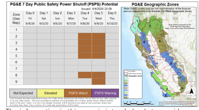
PGE already getting ready for the potential of a early wind event. They are setting up a PSPS watch five days before the event. They are saying that it is going to be closely monitored.
5 Likes
NWS SF: 3:30 AM Saturday…The upper level ridge is roughly 598 DM, which is confirmed by several soundings around the West that also show H5 at 598 DM. A high pressure system of
this magnitude is 2-3 standard deviations above normal. In other words, you don`t see an upper level high this time of year that often.
The upper level high is forecast to strengthen to 600 DM and build westward through Monday. The
airmass associated with the high pressure is pretty impressive too. A hint of it is already being felt on some of the Bay Area ridge tops early this morning. Several higher elevation sites are in the
80s as of 3 AM. The airmass will range from 27-30C at 850mb (measure of max Temp potential) Saturday through Monday. 850mb temperatures of this
magnitude are also several standard deviations above normal.
When it`s all said and done by Tuesday many temperature (day/night) records will be broken and
some of those could be all-time monthly records (most likely in SoCal).
After three days of excessive heat followed by gusty offshore flow is less than ideal.
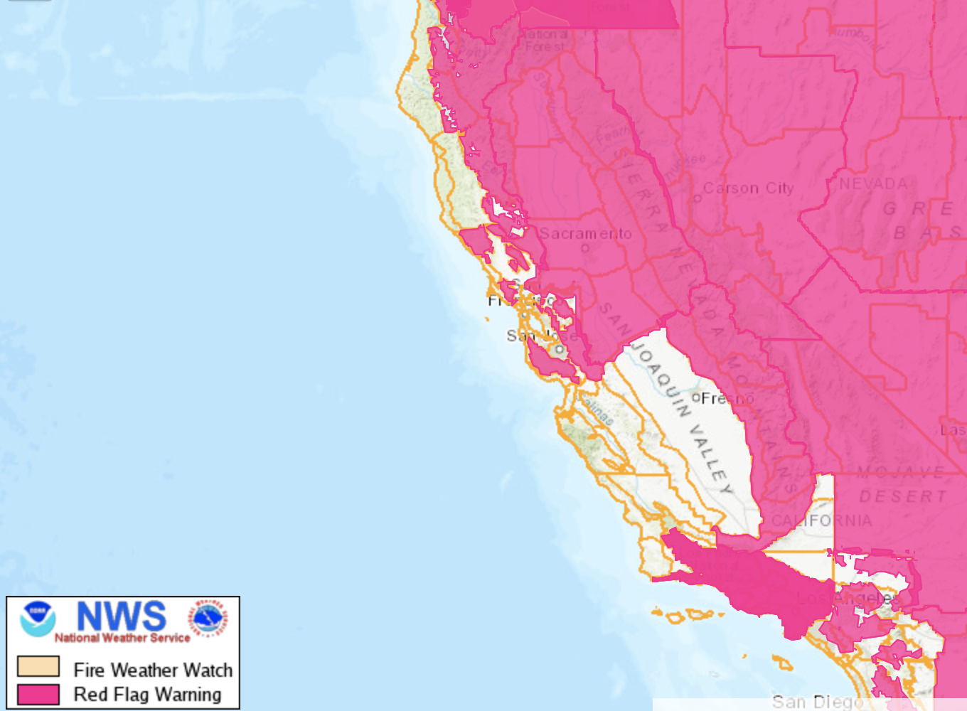
A Fire Weather Watch remains in effect Monday night for the N Mts and E Bay Hills. As the concern draws near the watch will be upgraded to a Red Flag Warning. Santa Cruz Mts may need to be
included in the Watch as winds appear to be gusty there as well.
4 Likes
Regional Forecast
Forecast Discussion
https://forecast.weather.gov/wwamap/wwatxtget.php?cwa=sto&wwa=excessive%20heat%20warning
2 Likes


PG&E just put out the PSPS alerts for the “critical” Northern CA areas on the map.
3 Likes
NWS San Francisco Bay Area
411 PM Mon Sep 7 2020
DISCUSSION: By late Monday afternoon and evening, northwest winds will begin to increase in the hills and become locally gusty. Winds shift to the north and northeast after midnight Monday night and increase in the North Bay Mountains and East Bay Hills. Strongest winds will occur above1000 feet in the North and East Bay late Monday night and Tuesday morning. Forecast models are trending stronger with offshore winds and locally gusty offshore winds are also possible below 1000 in the North Bay and close to the North Bay Coast late tonight and Tuesday morning. Winds will also shift to the north in the Santa Cruz Mountains and become locally gusty by Tuesday morning. Offshore winds in the hills will then remain locally gusty through Wednesday morning. Very poor overnight humidity recoveries are expected across the warned areas and daytime humidity will drop as low as the single digits by Tuesday.
2 Likes
Can see the exact moment the offshore winds hit the fires. Burning intensely now.
5 Likes
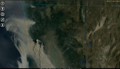
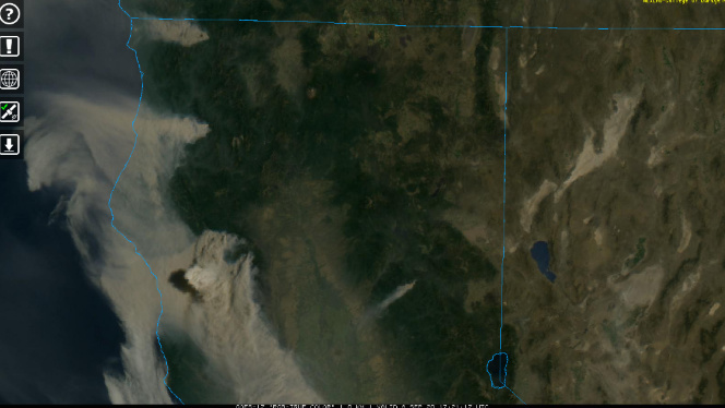
Anyone know anything about the smoke up near the Oregon Border? Is that near Gasquet, and does it have a name?
That’s KNF- Slater, near Happy Camp
Thanks, that really expoded big time. Hope everyone got out of the way.
There is a fire between the Creek Fire and the Slinkard Fire. Do you know anything about it?