NWS Forecast
https://www.weather.gov/sto/
1 Like
With the early season strong trough that is pretty quick moving and the north pacific ridge is going to build in behind it. The large size of both features is going to make for gradient driven offshore winds as cold air advection to the surface is pretty limited due to the track and warm air still remaining in the Great Basin at the surface. Later into the week a low pressure system could cut off at the base of the ridge and omega blocking develop. This could keep offshore gradients going for an extended period of time.
I think the big story for the next 5-7 days is not going to be necessarily very strong winds but very warm-hot temperatures and very low relative humidity plus offshore flow. If the cut off low undercutting the ridge mid week manifests it will provide mid level instability for a more dynamic plume growth situation.
12 Likes
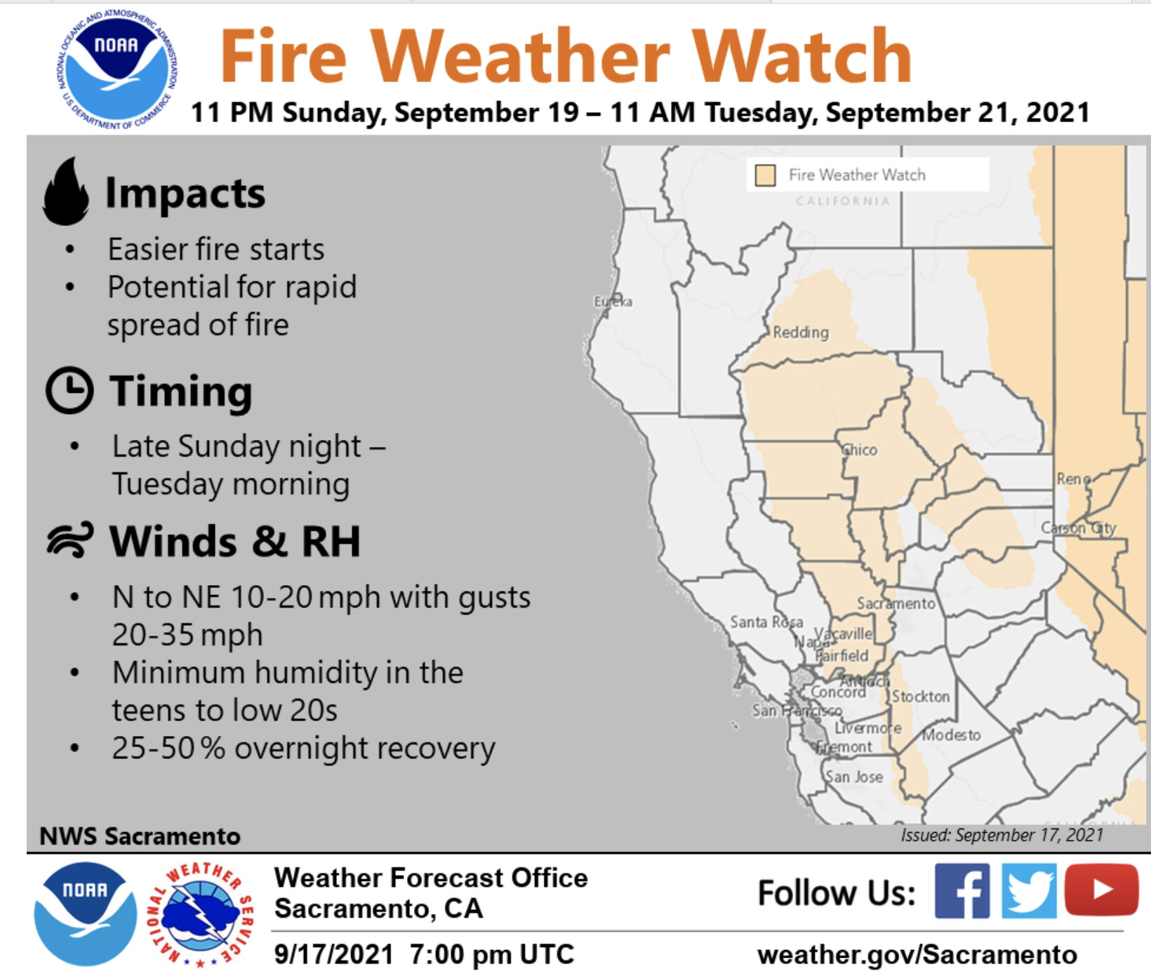
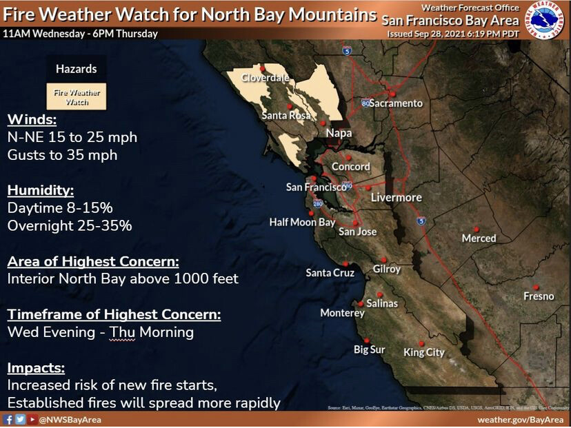
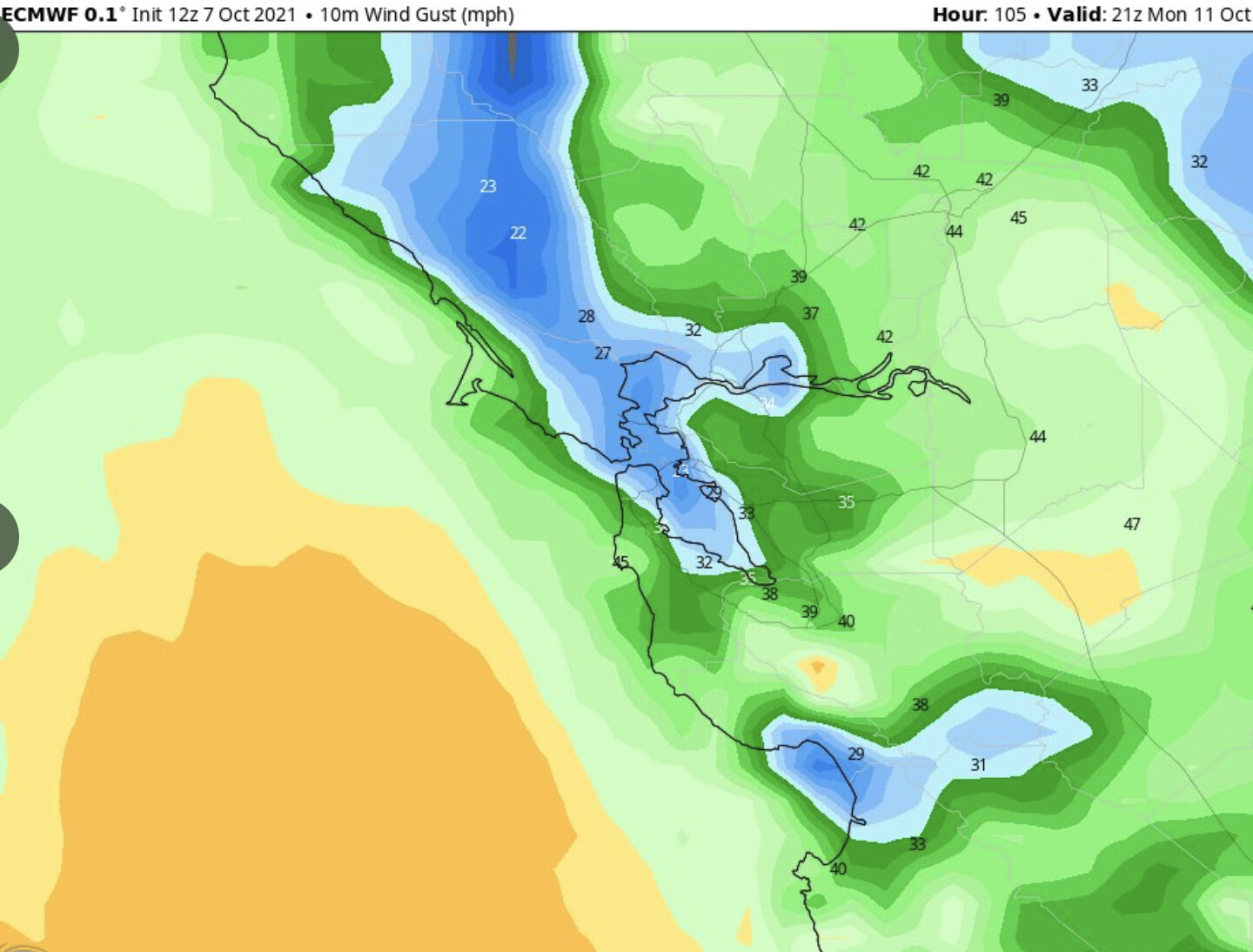
NWS: 0946 hours Sun …RED FLAG WARNING FOR DRY OFFSHORE WINDS FOR THE NORTH AND EAST BAY HILLS… The National Weather Service in San Francisco has issued a Red Flag Warning for dry offshore winds, which is in effect from 11 PM this evening to 8 PM PDT Monday. The Napa hills and East Bay hills that received less than a tenth of an inch of rain will be the areas of biggest concern. Initial burst of gusty offshore winds overnight to mid morning Monday. Drier conditions but lighter winds Monday daytime. Offshore winds ease Monday night with continued poor humidity recovery. * WINDS…Northeast 10 to 20 mph with gusts up to 40 mph. Local gusts up to 50 mph over the highest peaks. * RELATIVE HUMIDITY…Initially 30-45% tonight drying to 15-30% on Monday with little or no recovery Monday night.
6 Likes
Red Flag Warning for gusty onshore winds on top of low humidity on the lee of the Sierra 11 am Monday until 5 am Tuesday.
Winds turn out of the NNW Tuesday-Wednesday but most of the energy focuses into a cut off low over Arizona and the rest of the trough is just progressive across the midwest. So some isolated gusty winds but not a serious event as of right now.
9 Likes
There seems to be an anomaly this Fall compared to the last few years. We shall see if this holds up:
10 Likes
Waiting patiently for some of the pros to chime in on this…
Here is my take: early troughing now into mid October means the end of the month into November should be drier than average, because our weather in CA is very cyclical. So if we do not get a lot of wetting rain that ends fire season then offshore flow should return as the 12-15 day cycle of ridging amplification comes back around, with still the threat of fire danger… followed by another troughing cycle into mid-late November.
If we do not get a lot of atmospheric rivers this year to make up for the precipitation deficits we will be in a world of hurt come March and while early season storms look very promising a lot is hinging on where the hurricane in the Atlantic, and the typhoon in the Western Pacific go in relation to other features. These strong features always complicate model runs as a whole as they move north they destabilize cold arctic air.
14 Likes
Good morning, everyone.
I am working on a video for The Lookout about the spread of the Dixie Fire on the 4th-6th of August and wondering if anyone if interested in collaborating on some imagery of the frontal passage on the afternoon of the 5th. I have this screen capture video (Twitter link), but am looking for imagery that starts earlier in the day and goes thru dark.
I’d like to animate a sequence that shows how the frontal passage helped drive the strong southerly winds that caused the massive run west of Chester that took out 100,000 acres in 2 days. The GOES RAM Slider website doesn’t have archived data going back past about a week anymore, so looking for a source for a good high-res animation.
9 Likes
Interesting article. I’ve definitely noticed this:
[Nighttime air in the western U.S. has turned drier, drying out fire fuels - The Washington Post](https://Nighttime air in the western U.S. has turned drier, drying out fire fuels - The Washington Post)
5 Likes
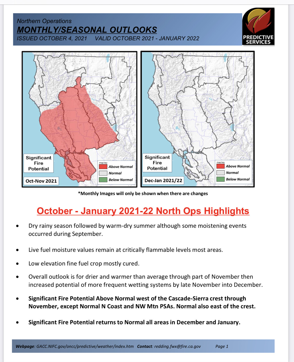
Continued moderated fire weather is still on track. Granted forecasting in the long range can require a crystal ball. This outlook for October is still refreshing to see.
NWS SF Forecast Discussion This Morning: By late weekend and early next week the closed low will have strengthened somewhat with falling 500 mb heights and advanced toward and across SoCal and eventually the Desert Southwest with some wet weather. If the GFS verifies the northernmost extent of light wet weather from this low would reach Santa Barbara County later Monday, too far south for our cwa. The door then opens up for one of the long wave troughs across the northern hemisphere to advance to the west coast mid to late next week, with increasing agreement and confidence in this solution in the deterministic and ensemble forecasts. Seeing this much activity so early in the jet stream is a sign of strength and a sign that shortwave troughs are prevailing feeding back to the long wave troughs (active wave pattern), overlapping our typical offshore flow season. Statistically and historically we can get wet weather this early in the season, what remains to be seen is will wet/wetter weather hold as we continue deeper into fall then winter before stabilizing to west coast ridging, which typically occurs temporarily mid-winter. Early next week cooler temps commence with a steady transition to troughing along the west coast with possibly wet weather later next week as multiple shortwaves dig into the long wave trough. This is a promising stretch of news especially because the trough and cooler temperatures could linger into the second week of October; this is typically our warm/hot offshore flow season.
6 Likes
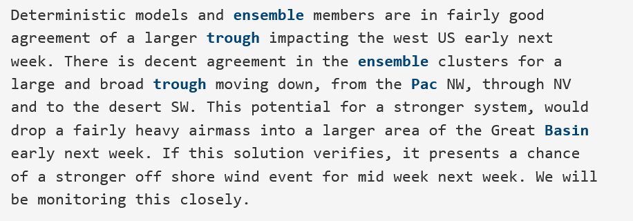
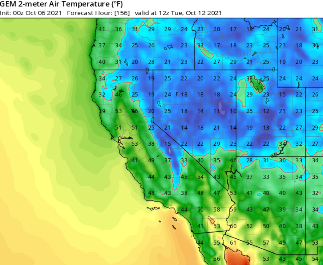
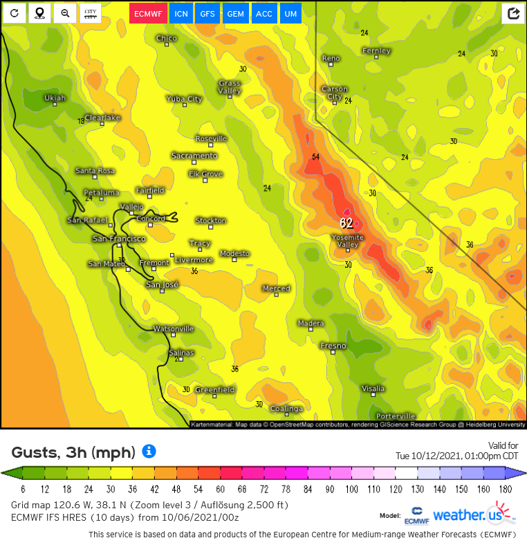
It’s early but there is increasing confidence that a potential Diablo wind event of moderate to strong strength could occur around the 12th-14th. Tonight’s model runs of the ECMWF and CMC bring a sharp trough through the Great Basin and into AZ. It is extremely cold in nature for this time of year and would bring snow to eastern mountain slopes like the Sierra. The trough axis as of current model runs is directly over the Sierra Nevada and this would bring a lot of upper level support but humidity levels could be non critical, at least the first part of the offshore wind event.
Will continue to monitor for model track adjustments but this does appear to be a strong offshore wind event signal with the typical mid range forecast track adjustments pending on the upper level features. Tonight’s GFS model run is further west but it’s ensemble mean is in line with the ECMWF so it’s wise to discount the wetter further west solution at this time.
From NWS Bay Area AFD
8 Likes
Looking out through November from ONCC Predictive Services, in spite of the mild fire weather in September there is above normal significant fire potential due to combination of dry fuels and lack of significant season ending rain.

6 Likes
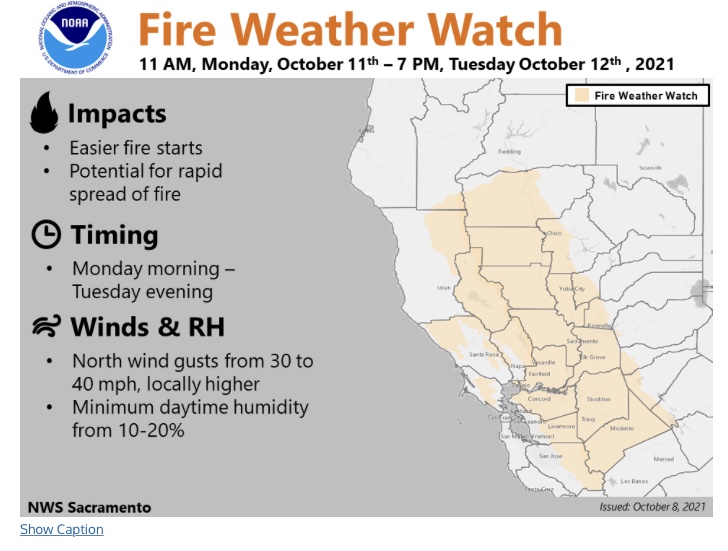
221 PM PDT Thu Oct 7 2021
…Fire Weather Watch for Monday afternoon into Tuesday
evening for gusty north winds along the eastern interior areas of
the North Bay mountains, East Bay hills, and East Bay valleys.…
The next weather system will impact the area early next week.
Moderate to high confidence in stronger north winds and drier air
early next week behind a passing cold front. The eastern interior
areas of the North Bay mountains, East Bay hills, and East Bay
valleys have the highest confidence in seeing gusty north winds.
The window for strongest winds will be from Monday morning through
Tuesday evening. These winds, in conjunction with little to no
recent precipitation and near to record dry fuels across the
interior, may lead to an increased risk of critical fire weather
concerns for the specified locations.
7 Likes