You are absolutely correct in your statements, but it’s important that we apply modern meteorological trends with the obvious lack of rain we have had. In 2015 most of LNU and surrounding Unit’s fires started under a high pressure influence. Rocky, Jeurusalem. I just think, given all we have seen over the past decade, mixed with a historically dry 2020/2021 winter, we are best to error on the side of caution, while planning and anticipating for the worst as well as hoping (No starts in critical areas) for the best. This is how we best serve the citizens of our state.
3 Likes
I don’t disagree we should err on side of caution, just a little tired of seeing every weatherman and their cousin suddenly playing fire expert on the news and social media, telling everyone to be terrified we’re headed into Armageddon with this season.
So many people are traumatized by last season’s acreages and destruction, I think a lot of the forecasts are just rubbing salt into everybody’s 2018 and 2020 wounds. But everyone who has been around awhile knows there is no way to really forecast the severity of a fire season. Things are critically dry, but IMHO, absent a mass-ignition event, there’s no reason this season will be exceptionally bad.
17 Likes
A wise fireman told me once, I’ll tell you in November.
12 Likes
Personally, I would not mind if our team did not get a roll this summer! Give everyone a rest! We have already have to many firefighters lose their lives! Just my thoughts…
5 Likes
Agreed on the weatherman part. I think what’s hopefully important to remember, take this time when activity is still low, to enjoy your loved ones, the potential is there to be gone. Fingers crossed, the season is quiet.
7 Likes
Pray for a persistent 3000’ marine layer all summer. That’s the best way to temper a potentially bad fire season. I’ve seen it before, it works great!
5 Likes
Or December or January 

3 Likes
This is what happened a couple weeks ago with very dry fuels under a marine layer…
High pressure means warmer temperatures, which means lower RH and higher fuel temps. Not sure how you cannot make a connection between HP and larger fires. There most certainly is a nexus. I would also argue that under HP air is more buoyant and with that warm air rises faster. The determining factor for Haines index or plume dominated fire conditions has to do with atmospheric capping. Just across the valley the Rattlesnake Fire occurred under very warm temperatures and the warm heat rising in the valley crated a heat low. That heat low allowed the extremely warm air in the valley to rise quickly and in doing so, it drew colder air from the coast through the gaps causing the fire to make fatal downhill run.
If we have learned anything over the past years as our fuels have changed, that is that a fuel driven fire such as the Carr Fire does not need a gradient wind to do damage.
The Lake County area is a great place to learn from. What we have seen occur, the fires used to slow down at night or even die out in the brush. That has not been the case lately. In fact reviewing the data, RH has been on average 10% lower in areas around Lake County. That is the difference between the Chamise carrying fire or the fire dying out once the fuel temperature drops. Other things come into play with HP ridges. Strong inversions can occur with very dry air trapped above, this dry air can settle in over the fire area and cause extreme fire behavior often at night.
Watch the overnight minimum temperatures and how the thermal belt will become entrenched this week, that will also serve to assist in the drying of the fuels that are within the thermal belt regions.
This HP ridge will serve to complete the drying process for all the grass in the foothills and bring the elevations between 1800-2500 feet on line by next week. Watch the effects of the ridge on the ERC and the BI’s.
As far as anyone handing out warnings… is that not what we need? We need to remind people to be careful, to pay attention to what they are doing and to take the time to prepare their homes( at the right times). It is a total force concept where any media outlet we can use should be maximized.
With regard to fire season- agree it is hard to predict… what we do know is that all the metrics are in place for significant fire activity.
13 Likes
Buckeye is dropping its leaves and the Poison Oak is turning red. One of the earliest dates I have seen it do that. Good visual indicator that the brush species are tipping over and we should see any short term increases in the FM begin to decrease- most likely rapidly. Watch your smoke color change and we should begin to see fires going into extended attack on a more regular basis. Even with the cool down next week and increase in RH- I would expect to see ERC’s take a significant uptick.
7 Likes
I don’t see anything re that
Red Flag in sku ??
The tweet / FB post I attempted to share were both deleted shortly after grabbing link and screenshots. On all of the posts it pretty much said the same thing “Can we get a source on this?” I figured maybe they saw something I didn’t but it appears it was wrong.
My apologizes.
edit; I removed that post to avoid any confusion.
1 Like
There was a RFW for lightning issued by Medford that ended at the state line( clouds are respectful of boundaries), but the banner for the Medford office did mention Siskiyou for lightning.
There was no actual RFW issued for SKU.
5 Likes
The Buckeye tree/bush along with poison oak were my two indicator species of fire behavior change. Both plant species will shed their leaves to reduce their transpiration rate (water movement and evaporation through the leaves/stems). When both of these plants are no longer foliated in drainages and north facing slopes, it means soil moisture has dropped and live fuel moisture will start to plummet. I used to teach this to the new fire recruits during area familiarization tours in the north part of SCU.
16 Likes
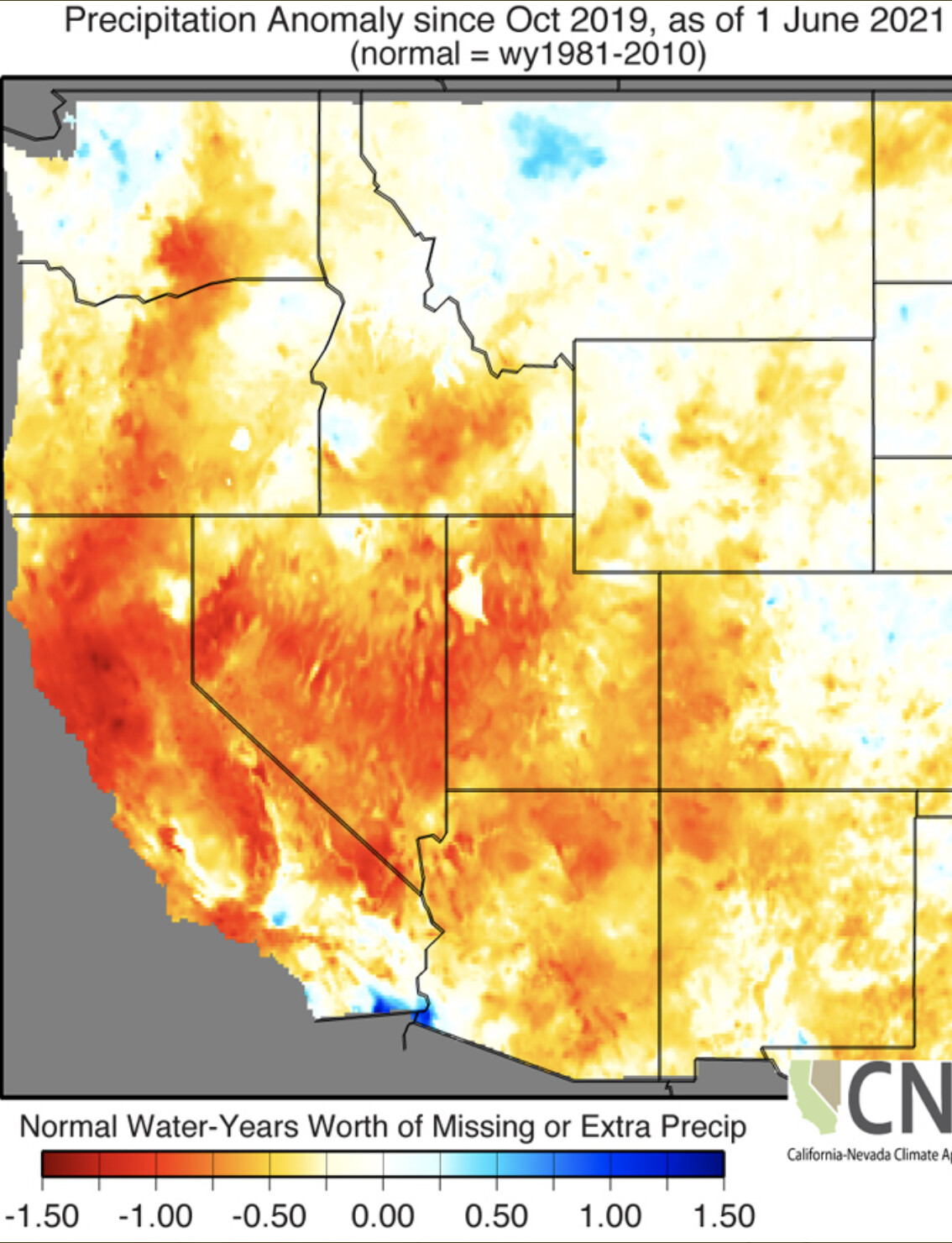
Since October 1st, 2019 much of California and other wide swaths of the West are “missing” nearly 1 year’s worth of precipitation. At the epicenter of this drought in NorCal, up to 1.5 years’ worth of precipitation is “missing” over the last 20 months!
7 Likes
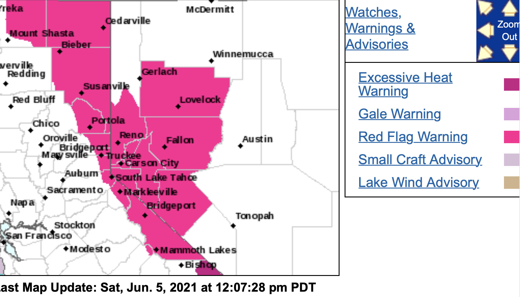
NWS in Reno has issued a Red Flag Warning for gusty winds and low humidity, which is in effect from noon to 11 PM PDT Sunday and from noon to 11 PM PDT Monday.
-
Winds…West to Southwest 15 to 25 mph with gusts to 40 mph.
Gusts up to 45 mph for wind prone areas. -
Humidity…7 to 12 percent in western Nevada…10 to 20
percent in the Eastern Sierra, Tahoe Basin, and northeastern
California. Poor to moderate recovery Saturday night. -
Duration…4 to 8 hours each day.
-
Impacts…The combination of gusty winds and low humidity can
cause fire to rapidly grow in size and intensity before first
responders can contain them. -
Dry and gusty winds are expected today as
** well, but the peak of the wind event is expected Sunday and**
** Monday.**
2 Likes
Perhaps that hope of the 3000’ foot marine layer along the coast, all summer long, may come true!
https://www.cpc.ncep.noaa.gov/products/predictions/610day/index.php
https://www.cpc.ncep.noaa.gov/products/predictions/610day/index.php
2 Likes