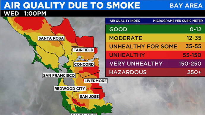
NWS - SF 9:30 pm: A significantly more energetic vorticity wave will roll in and accelerate the descent of the low pressure system into the lee of the Sierra Nevada and into the Great Basin. We generally refer to these patterns as “insider sliders” and they are particularly concerning because of where they often position our area – on the dry, windy side of the trough/storm system. To compound issues, they are ideal for generating offshore flow, which is a risk as these winds often bring even drier conditions than they would have otherwise due to downsloping/terrain effects. Generally, these type of systems arrive in the latest stretches of the summer through the fall, so this system is a bit early. As such, we are expecting a round of gusty offshore winds (sustained 10-25mph with gusts 30-45mph) and very dry conditions (8-18% for the driest areas midday, poor overnight recoveries) for the interior North and East Bay mountains, particularly from Tuesday evening into Wednesday, but possibly again more locally Wednesday night into Thursday. In addition, fuels are at record dry levels across the areas expected to be impacted by these windy and dry weather conditions, thus a fire weather watch is in placebeginning late tomorrow evening. The development of extremely critical fire weather condition across the state means that wildfires burning to our north will likely intensify and generate more smoke than they have been. Thenortherly winds will then transport this smoke southward towardsthe San Francisco Bay Area by tomorrow night before tanking air quality through the day on Wednesday.
I originally thought the trough would be progressive since it is early in the year but… now this looks likely.
An inside slider 30 days early with mega fires burning, what is this the apocalypse…
Could be a day to remember. (Or forget)
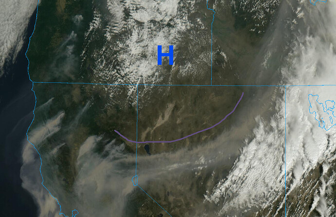
Good morning… a surface cold front is moving into the Great Basin just north of Lake Tahoe. This is rare for this time of year, and absurd considering this area is going from high temperatures in the 100’s to the 60’s in 3 days. There is leftover heat that is absorbed by the ground that moderates temperatures, so knocking temperatures down this much goes to show how potent of a cold storm this is… farther north highs will struggle to get into the 60’s.
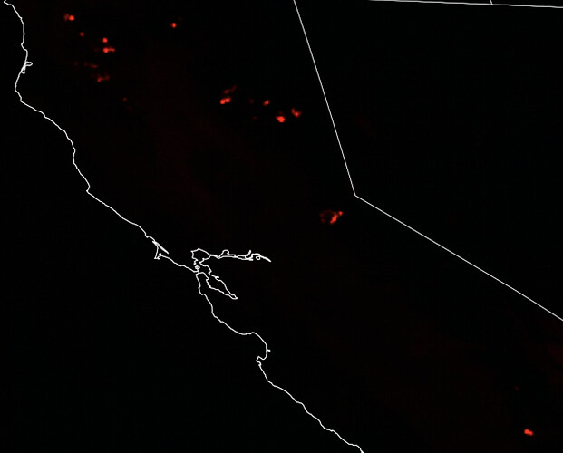
On the satellite image you can see the surface cold front defined in the smoke arch just north of Lake Tahoe, and the subsequent surface high pressure to the north. Offshore winds are surfacing from this offshore flow as seen by the smoke direction on major fires in the Klamath’s and the northern Sierra. This surface high pressure should lead to compression warming and drying west of the crest for high fire spread potential.
The limiting factor for higher offshore winds surfacing will be the smoke preventing gradients from steepening too much.
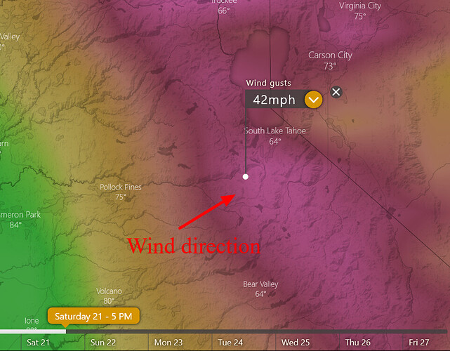
Offshore flow should continue for the next 48 hours before a shortwave drops out of Canada, into Oregon and reverses the flow to onshore. Due to upper level high pressure building into the SW there should be gusty onshore winds (especially on the lee of the Sierra) this weekend as onshore gradients steepen.
This see-saw of onshore flow to offshore flow is something we usually start seeing in mid to late September for North Ops, and will pose containment difficulties as the fire direction changes.
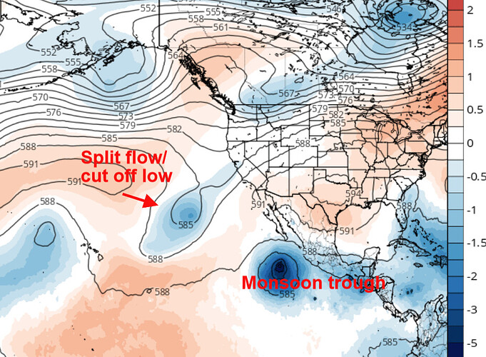
Looking farther ahead… high pressure should begin to rebuild over the entire west coast through D10, we are entering the time of the year where tropical remnant-cut off low interactions are most likely and this will need to be watched for additional lightning bursts as the eastern pacific has become more active.
GFS 138 hrs
Normalization of deviance.
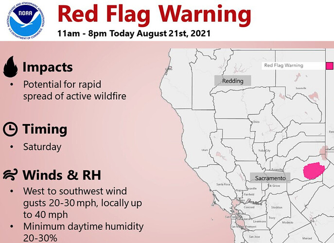
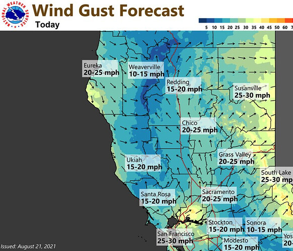
NWS - Sac at 10:00am Winds are forecast to increase today leading to elevated fire weather concerns over the foothills and mountains. Southwest wind gusts of 20 to 30 mph, locally higher are possible.
Question:
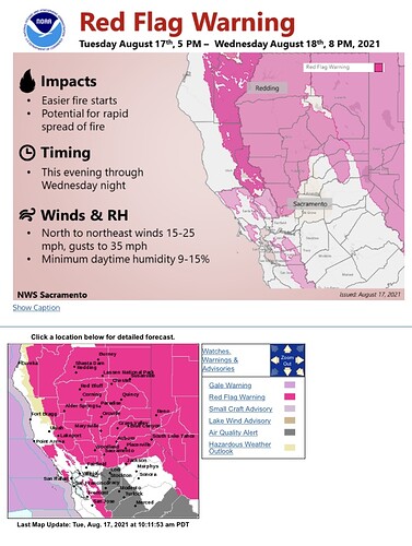
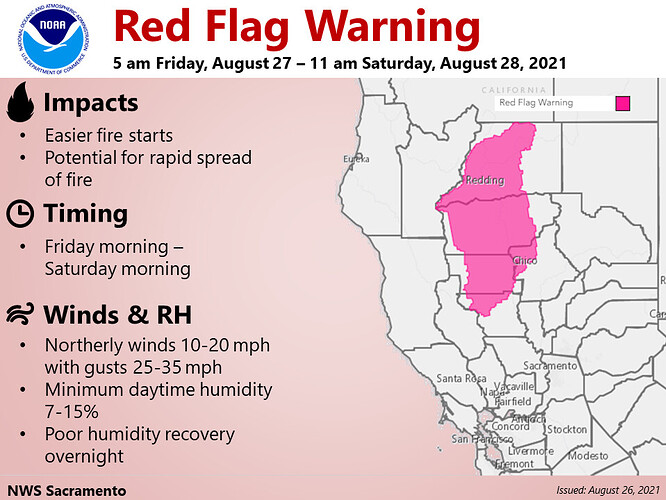
It seems unusual to see a RFW with such a tight geographic area as this one. Usually they cover quite a few zones.
Is this being issued because there is already a fire in the area, or are the stars aligned such that conditions will be worse directly over the fire?
It is due to the active wildfire already burning. RH values technically do not meet Red Flag Warning criteria.
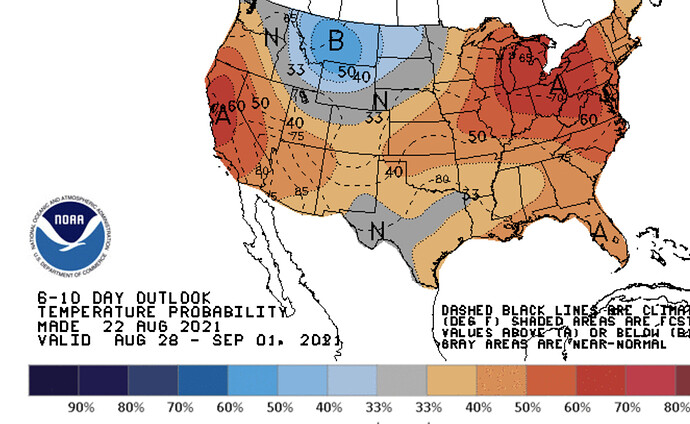
Could see some critical fire weather on Friday into Saturday as a shortwave enters the upper Great Basin… surface high pressure will build in it’s wake leading to northerly flow. Already hot temperatures, could see some channeled northerly winds and low humidity.
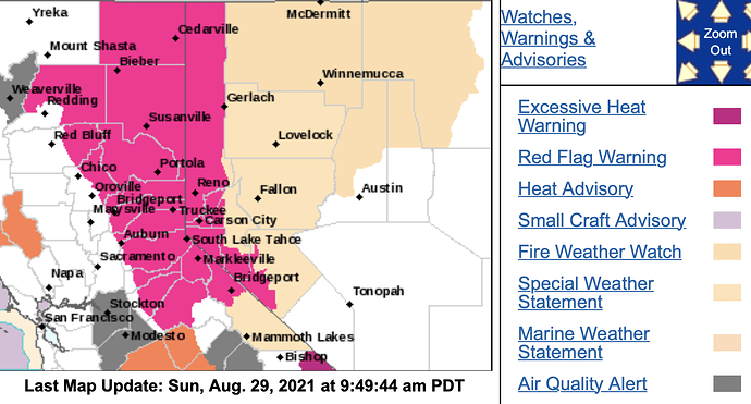
NWS Sac: 930 AM PDT Sun Aug 29 2021
…Red Flag Warning Monday through Tuesday Evening for the Sierra
Nevada and Southern Cascades…
.Gusty west to southwest winds are forecast to develop over the
Northern Sierra Nevada and Southern Cascades this afternoon and
lasting through Wednesday. The strongest winds are expected late
Monday morning through Tuesday evening, which combined with low
humidity and extremely dry fuels will lead to critical fire
weather conditions during this timeframe. Elevated fire weather
conditions are possible this afternoon through Monday morning over
mountain ridges and near wind prone gaps and canyons and may
continue into Wednesday due to locally gusty winds and lower
humidity.
Good evening.
Forecast models are in agreement that the Pacific NW trough will move into the Upper Great Basin through Thursday. Gusty onshore winds on top of hot temperatures and already burning fires will likely lead to rapid expansion of already burning fires. Due to aerial resource competition and scarcity, successful initial attack on any new ignitions is paramount.
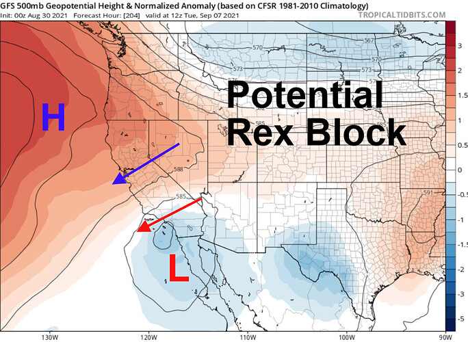
Forecast models are in general consensus that an upper level low pressure system will cut off into Southern CA through the weekend and this will lead to rising heights and offshore flow from the NE. Hot and very dry conditions will likely be king through this time period as an elongated ridge could form directly over the middle of the state and a blocking pattern develops. Looking a bit further ahead… a large trough could dive into the Rockies, which would build surface high pressure into the Great Basin and reinforce gusty offshore winds through day 8. This would compound the heatwave greatly as offshore flow increases and the upper level high pressure continues to dominate, tilted downward from the ocean to the surface in the great basin.
It is difficult to forecast this far in advance, but this should be watched because historically this is the potential most likely date for a lightning burst off of the ocean (will there be anything left to burn by then?)… The upper level trough digging into the Rockies could amplify the high pressure and could kick the cut off low off of the coast of Southern CA upstream and depending on the atmospheric conditions produce widespread dry lightning. Forecasting the sypnotic set up 9 days in advance is tricky especially when it comes to cut off lows but just know the upper level pattern looks extremely amplified and energetic, climatology comes into play, and the intense heat wave that could develop beforehand increases the chances of receptive fuels.
Bottom line is it is going to be windy, hot, and dry through the next 10 days.
Red flag warning extended until 11pm tomorrow
Looks like you may have nailed this one albeit a day or 2 early…
Forecast is on track. Sunday-Tuesday temperatures could be 10-15 degrees above normal. Chance of elevated convection next week. Ridge could rebuild late next week, but forecast models diverge significantly on the pattern starting on Thursday of next week ranging from strong onshore winds and troughing, a cut off low, or high pressure.
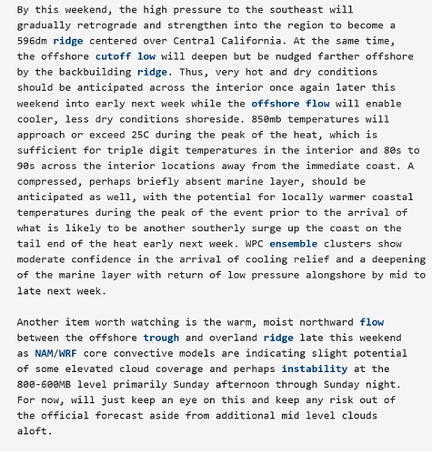
From NWS Bay Area:
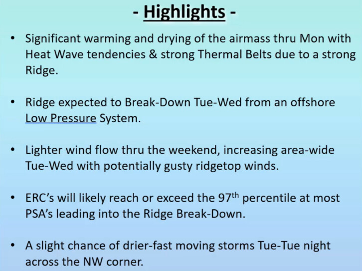
From North Ops forecast:
“Tuesday/Tuesday night will be monitored very closely across the NW corner of the region due to the threat of drier/faster moving and potentially nocturnal thunderstorms. Confidence is low to moderate at this time.”
Well maybe not North Ops specific… just weather… but the uber-science is trending towards a significant repeat of last winter season…
https://www.cpc.ncep.noaa.gov/products/analysis_monitoring/enso_advisory/ensodisc.shtml
