The climate has always been changing. It’s the cause that is the debate. 150yr ago the entire central valley was under 10+’ of water and the population of California was 10% of what it was in 2022. The fallacy of mankind is the failure to learn from the past, studying and learning from history.
Not sure it is a fallacy… The issue with our current weather patterns is that we are in territory that we have never been in, so we cannot learn from the past.
The rise in Co2 in our atmosphere is comparable to large scale eruption of a volcano, the problem is that we have not experienced an eruption on the scale that would trigger the same set of circumstances.
As we watch our overnight minimums increase, the thermal belts thicken and our general temperatures increase we can expect shorter more intense winters, with much of the precip falling as rain and not snow.
As for the “The Great Flood of 1862” that was not a climate anomaly but rather an expected cycle. We can learn from that and have to some extent. Without the levees and dams in place, we likely would experience a flood at or near that magnitude on a much greater return interval.
The paradigm shift has to include expecting fires to burn freely overnight with increased burn periods.
The dead components existing in our fuels will carry us over during wet years. That was evident in 2017. We set records for total accumulated precip at multiple Northern Sierra indexes, only to have a crushing fire season that summer.
So this poses a big question, “Why?” With the state being in the fifth year of drought, bug kill, record low fuel moisture. It seems that the state was primed for another big fire season. The numbers of acers burned show that the 2022 fire season was only 20% of the rolling five year average. WHY?
Mild summer temps
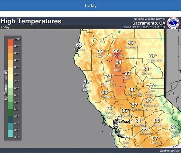
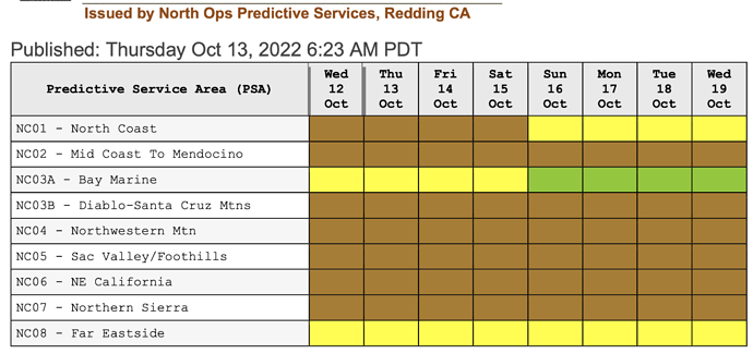
No “Red Flag” weather this year
More aircraft
Helicopters able to do night ops
More LATS and VLATS
More firefighters, engines, Cal OES agreements
Wildfire cameras
No multiple starts
Just got lucky
What does the group think is the reason for the below average acers burned and what do we need to do next year to keep it up?
Some other factors I can think of besides the above
-Nothing left to burn (the fires of the past few years were so enormous as to eat up a lot of the available land)
-Much experience gained by the up-and-coming in the past few years that fires get stomped quicker
-Ignitions are always the biggest variable, ignitions not happening in difficult spots
The first two on your list are WEATHER and there isn’t a darn thing we firefighters can do about that.
I didn’t see nearly the same number of UTF’s this year for Charlie, Lima and Foxtrot Strike Teams as last years. More handcrew availability making up for the lack of inmate crews. Fewer fires at once allows for adequate resources to do the work. Flying more than the bare minimum of aircraft on initial attack. I think of a half dozen starts this year that occurred within burn scars from the last 5 years. A robust monsoon that dropped well over an inch of rain or more everywhere. Just fortunate this year. Still time for some off shore winds. (Although nothing really in the 10 day forecast.) A lot of damage can occur very quickly.
That was a great question. This was just like a normal Fire Season of years past. The fuels in the Motherlode weren’t ready to burn to the very end of July and beginning of August. Then in Sept we got a good rain. That really slowed things down. We did have heat fallowed by cooler temps. Some of the stops on fires were made by damn good IA and sometimes you get lucky. The fires in NEU that looked like they were going big, they smashed them hard. The location of MCC and having Vlats and Lats available definitely help with quick turn around time on fires . The State putting Type one Helitankers like at Columbia help out on IA for TCU and MMU. A few more Arsonist were taking out of the picture by the prevention staff and that always helps cut fires down. Collectively it was just a lot of things. Ground troops and Air Force did a good job on IA and extended. We haven’t had a strong north wind event for Northern and central CA yet this Fall.
#1 has to be lack of available fuels both from number of acres burned in previous years and the dry spring and winter not providing for a large crop of fine fuels to grow. The additional type 1 helicopters and heli-tankers was also a complete game changer. Obviously boots on the ground are what contain fires, however having 3.33x and 10x drop capacities for Firehawks and Chinooks respectively compared to Bells does a lot to knock the steam out of the heads of these fires. A lot of weather factors as well thankfully helped keep things manageable.
There was not a big lightning bust. Those have contributed many many acres and sucked many resources in the last 5 years.
Also this was not a windy year. Not many dry fronts crossing the state.
Weather really does have a big role.
Random variation. In 2019 only 259,823 acres burned. If fires start in a place and at a time when fuels, topography and weather all drive extreme fire behavior, they’ll grow until one or more of those conditions change. We should keep doing everything we’ve been doing. Aggressive hard hitting IA with massive air support has saved the day more than once this season, but so has a lack of fire starts in inaccessible areas with heavy fuel loading and extreme wind conditions. Not really the time for a victory lap yet though. The Camp fire started on Nov. 8, 2018.
I think us saying that there is minimal fuels not to burn in prime areas where history shows we get those extended attack fires is true to a point, but there are still areas, like the northern LP (i know this is Norcal Weather) that can and are ready to burn again. And some areas still showing minimal fire history. I think this year in particular we didn’t have some of the patterns like we did in the past. No crazy lighting spurts although we had the potential with the hurricane’s that spun off the coast of Mexico. And so far no major wind events in the north. Only time will tell for the rest of the year.
No big lightning events up and down the state. Resources and teams were readily available. Last year we were hammered along with ID and MT.
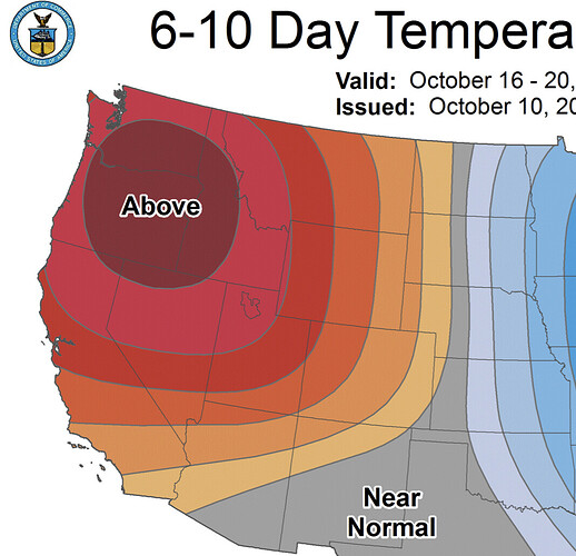
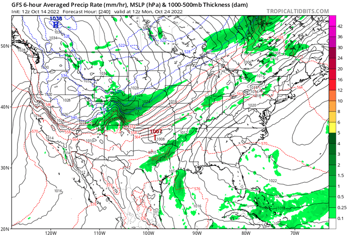
Model tendencies appear to be hinting at the Blocking pattern re-asserting itself after a brief interruption early next week.
Inside slider setting up in GFS for Oct 25/26-27/28th? Seems like it is constantly changing but this seems like the strongest signal thus far this fall.
I would not trust the GFS that far out. It has been waffling between a significant and prolonged offshore event for Nops and a potent storm system. The ensemble models are hinting at troughing. We will have a better idea in 2-3 days. Both options are viable for this time of the year, a cold core storm series followed by offshore flow, or a grazing shot of rain well to the north with cool air followed by a strong offshore event. We will see…
The blocking pattern in a way has extended summer for much of the west, as it has been warm and dry with no monsoon across the interior west and no inside sliders. It’s made mid or long range forecasting impossible. If the blocking occurs it could extend the fall inside slider pattern into winter when it materializes. It looks like the rest of the month will see a blocking pattern. This is a pure guess but wouldn’t be shocked if the first notable inside slider occurs around November 3rd-November 8th time frame.
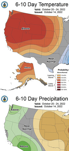
A little less variability in the run to run patterns. Starting to think that the above normal precip will evaporate…
The trend has been to keep any precip north of the state line and only knock temps down before a strong offshore flow develops. Still a ways out. Both scenarios are entirely plausible — cold core storm with a wetting rain— rain for the PNW and California gets a strong multi-day offshore wind event…
