The link on the SOPS website is still trying to point to Fuel Model G. Change the G to a Y for the new stuff.
2 Likes
Forecast models are in good agreement. Instead of those 600 DAM heights over North Ops, maximum heights will likely be about 5-7 dm lower than that. However, the trade off is increased northerly flow over the Sacramento valley and North Bay as surface high pressure builds into the Great Basin.
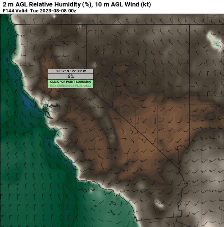
The combination of weak offshore flow and strong high pressure should bring compressional heating to excessive levels this weekend. Maximum temperatures could approach 115 degrees.
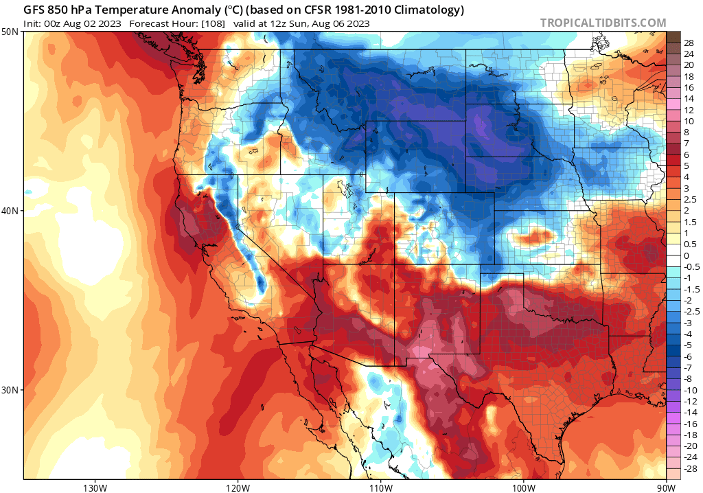
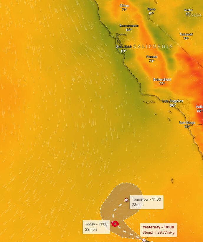
Here is a depiction of the weak, localized Diablo wind event through temperatures at 850 mb (5,000 feet)
The combination of weak offshore flow and strong high pressure should bring single digit relative humidity values to inland areas, with poor overnight recoveries in the foothills. Critical fire weather conditions will be likely during the afternoons.
11 Likes
When is this happening brother?
3 Likes
Saturday-Monday
8 Likes
Great analysis as always Anvil. Since many read and learn on here I just want to point out the rough height of the 850 mb level is 5000 feet ( I know you know this and it was likely a transcribed error or thinking about 500 mb level ~ 18,000 ft).
For those that want a deeper dive on actual sounding data the University of Wyoming is a great site.
7 Likes
My error, thank you
4 Likes
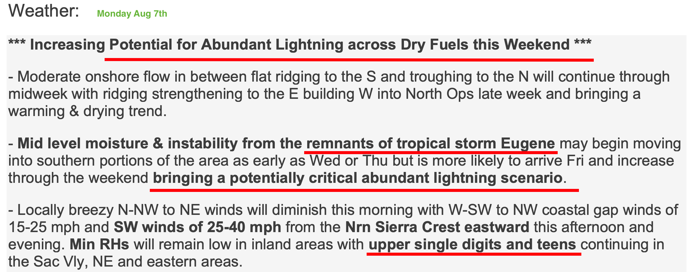
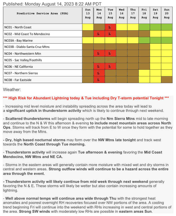
North Ops 7-day Significant Fire Potential Outlook - Tuesday AM:
-
Mid level moisture & instability from the remnants of tropical storm Eugene may begin moving into southern portions of the area as early as Thu night-Fri, but is more likely to arrive Sat-Sun and increase through the weekend likely bringing a critical abundant lightning scenario.
-
Isolated thunderstorms possible as early as Thu night into Fri in Santa Cruz Mtns-Bay area & Sierras near Tahoe. Confidence is low that these will occur, but they are likely to be dry if they do & could be overnight-early morning.
-
Scattered thunderstorms w/abundant lightning likely Sun-Mon as an inverted trough moves across N Ops. Highest chance NW Mtns & N Sierras, but will need to monitor for need to add
additional PSAs as details become clearer on timing/coverage. Storms likely to be a mix of wet/dry. -
A significant late season heat wave will come in with & follow the lightning threat this weekend into next week w/temps peaking early next week at/near record values for the calendar date & possibly close to all time records for the month of Aug.
Fuels/Fire Potential:
-
The most noticeable flammable fuel alignments (both live & dead) will be found below elevs of 4-5kft where dead fuels are generally quite flammable & live fuels will contribute to fire spread.
-
Hotter & drier weather combined w/increasing lightning chances late week into this weekend
is likely to result in a critical pattern this weekend into early next week bringing increasing fire activity to N Ops. HR may be need to be added to additional PSAs in the Sat-Mon time frame.
16 Likes
Still a few days out but confidence is increasing for some type of convective activity across central and northern California by Sunday. The strength of the low and the mid level moisture will be the triggers. Fantasy land soundings are showing a mix of dry and wet storms. The heat following will be a factor and could work to allow any fires to become more active.
10 Likes
Thursday AM: Issued by North Ops Predictive Services, Redding CA
*** High Risk for Abundant Lightning On Dry Fuels N Sierras Sun-Mon & NW Mtns Mon-Tue ***
Mid level moisture & instability from the remnants of tropical storm Eugene will move into far S portions of N Ops tonight-Fri w/a slight potential for isolated dry T-storms possible in the Santa Cruz Mtns-Bay area tonight-Fri & a better chance of isolated T-storms across the Sierras Fri PM, esp near Tahoe. Confidence is low that these will occur in the Bay area & moderate for the Sierras.
-
Isolated thunderstorms are likely to expand N-ward to NW Mtns Sat afternoon-evening into Sun. Currently, these storms look to be isolated & dry. Timing is uncertain, as most of activity N & W of Sierras could hold off until Sun.
-
Scattered, mixed wet/dry thunderstorms w/abundant lightning are likely to develop in the Sierras Sun & move WNW-ward to the NW Mtns Sun night-Mon as an inverted trough moves across N Ops. but will need to monitor for need to add additional PSAs, esp NC05/NC02, for Sun night-Mon.
-
Mixed wet/dry scattered T-storm chances continue Tue NW Mtns, w/isolated mixed wet/dry T- storm potential in mtns surrounding the Sac Valley. Iso T-storms could linger each afternoon/evening later in the week.
-
A significant late season heat wave will come in with & follow the lightning threat this weekend into next week w/temps peaking early next week at/near record values for the calendar dates.
Fuels/Fire Potential:
- Hotter and drier weather combined with increasing lightning chances late week into next week are likely to result in a critical pattern this weekend into the middle of next week bringing increasing fire activity to North Ops. High Risk may be need to be added to additional PSAs in the Sun-Tue time frame.
9 Likes
Well, i think “it” is here given RH is on the climb & temps sliding down a notch or two suddenly here in southern shasta/northern tehama cnty. Gidde-up!
4 Likes
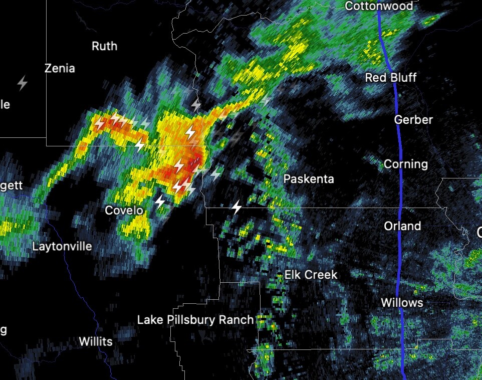
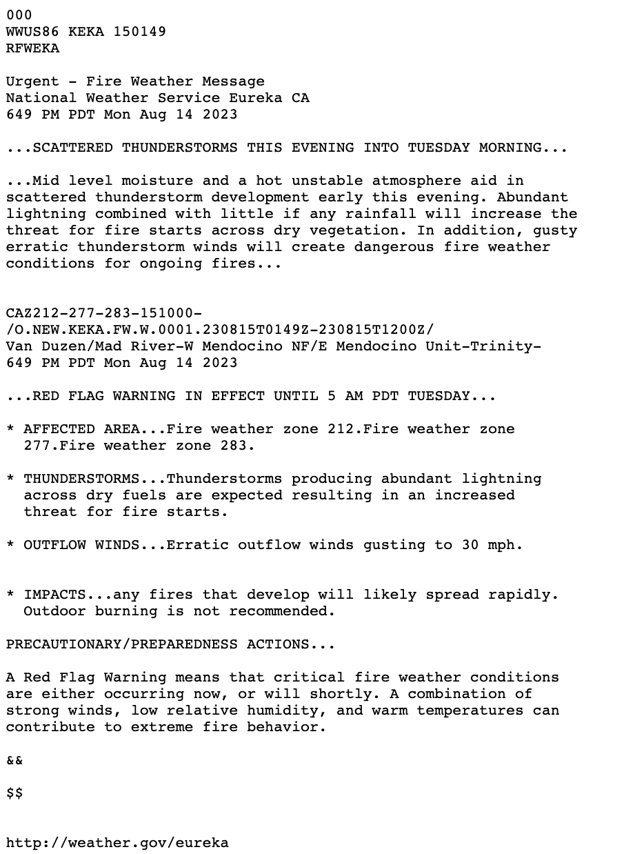
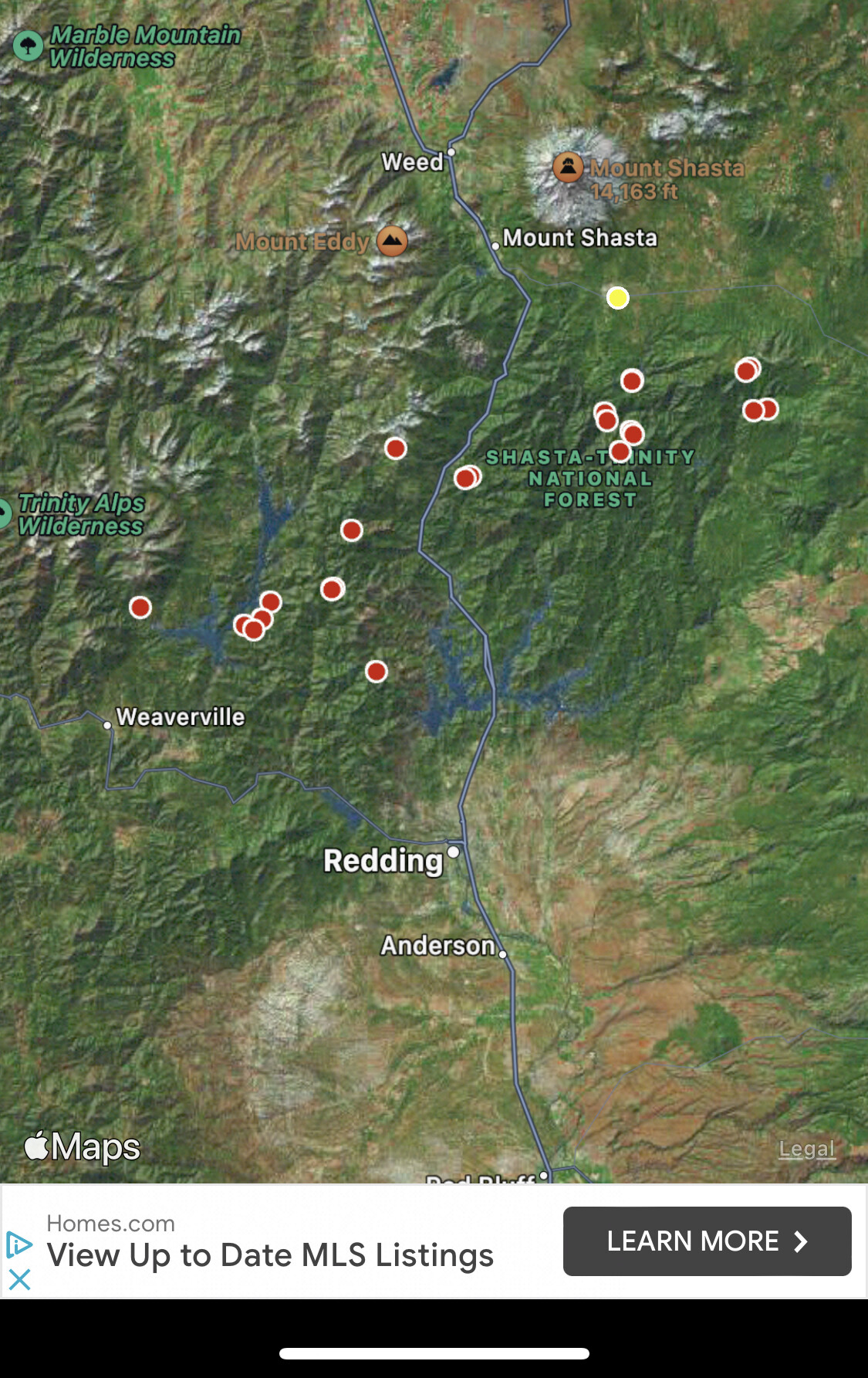
The Northern Mendocino NF is getting lit up. Much of this area was decimated three years ago by the Mendocino Complex so there should be good access and manageable fuel. However, I’m sure the next few days will be busy unless we get a bunch of rain.
5 Likes
Good chance it’s going to be a long day in Nor Cal tomorrow once the sun comes up…………
6 Likes