Potential heat wave first week of August as the ridge re builds.
While the GFS isn’t good in the mid term of the forecast, it does fine with high pressure systems because it has a bias towards heat… so I will point out the following. The ridge is currently set to de amplify and move to the east through the end of the month, 850 mb temperatures (above the inversion) are excessively hot still and would take time to mix out. At the same time, a kelvin wave moving across the Pacific moves into the west coasts waters. This is a wave of warm water that moves across the ocean.
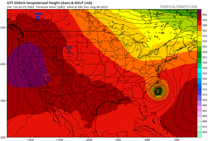
The GFS brings a strong hurricane towards the eastern sea board the first week of August, which will likely dictate whether this scenario occurs. The associated blocking pattern that develops on the model leads to strong high pressure development over the Pacific NW and California. If this type of set up occurs it would be an ‘excessive heat emergency’ type scenario as we are at peak heat climatology speaking and excessive heat lingering above the inversion, plus very very warm SST’s and record 500mb heights.
With the all time record sea surface temperature anomalies we are seeing in the Northern hemisphere occurring and the climatological peak still in the future, a heat transfer mechanism to the poles must occur… and this process could produce some unbelievable weather. A buoy off the coast of Florida at 5’ recorded a SST of 101.1 degrees.
https://twitter.com/DrJeffMasters/status/1683660816610893826
Continued longwave radiation absorption into the ocean occurring like I mentioned earlier in the year.
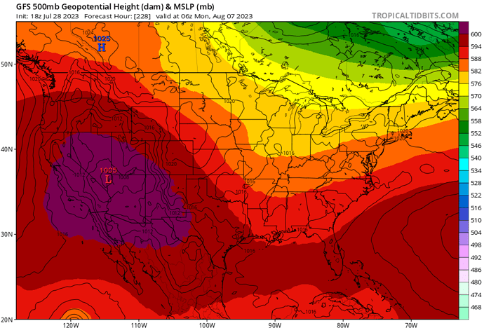
Update on this. The GFS continues to advertise this situation, albeit slightly to the SE. This would bring near all time record 500 mb heights to California for these dates. The temperatures above the marine inversion would likely kill trees and vegetation.
There is pretty good ensemble support.
The operational ECMWF keeps the high further east, but it is way less bullish on a tropical cyclone on the Eastern Pacific so that is a major factor. Other things could complicate matters such as if one of the cut off low pressure systems develops into a tropical cyclone in the Atlantic.
Well that sounds bad. Any idea as to what kind of temps we could be looking at? Also curious about when you say ‘above marine inversion’. Does that mean this is more of a coastal thing or altitude based? I appreciate your posts and learn a lot from them. Thanks for your inputs.
Anvilhead you always provide great weather intel. Thank you.
I appreciate it! Yes I mean near the coast, there’s a sharp gradient where if you go either up 500 feet or inland a mile… temperatures are 20 degrees warmer. As far as temperatures go, it depends on where the center of the high sets up. If it’s a situation like this, temperatures in the Sacramento and San Joaquin valleys could exceed 120 degrees.
Thank you! I appreciate it.
Holy moly! Thank you!
So basically the temps/heights that have been smashing all of Az heat records will now be sitting over Ca if this pans out…?!
What is the timeline for this? I also appreciate your posts, they have been a great tool in helping me plan.
That is correct, but a caution as there is some disagreement between the placement and strength of the upper level high. @Clayton A safe bet is from 8/5 to 8/8, and a blend of the placement and strength between the EC and GFS.
The GFS has this strange curve where it can get something correct 10-14 days ahead of time then go off the rails for the next 4-5 days, then revert back to what it showed before. The models will probably agree completely with each other by Monday.
Was going to ask your confidence level, but you stated that. GFS was bullish on some crazy heights but now also shows a strong trough right after it.
If that run verifies, short up and down. Ensembles are more run of the mill.
Is this chaos due to the tropical system.?
If the trough were to verify good chance of a lot of wind, slight chance of a dry cold front with some convection?..
Yes that is correct. The tropical cyclone creates a weakness in the ridge that would not normally be there so it allows the trough to sharpen. The GFS has a warm bias though so what often happens is it will overestimate how fast cold air masses move. At the same time it develops tropical cyclones too quickly because of the warm bias affecting convection development.
A sharpening trough leads to amplified weather because the jet stream wants to move west to east, when you add a speed bump to the jet stream it causes the air to pile up over it, and the outflow from tropical cyclones sinks enhancing high pressure. So that’s why I watch tropical cyclones for our weather. They are compact little troughs that actually cause the air to pile up around it and sink. Former 95L and 96L will likely affect us in indirect ways.
So ultimately if both invests develop they will enhance primordial flow and thus ‘amplify’ the weather. These occurrences are in reality reflections of what happens on the sun, but that’s a whole different topic.
Exceedingly hot yet highly intriguing rabbit hole… Sounds like fun let’s go!!
High “boom bust” potential when that much energy is moving through the atmosphere. Climatology would suggest ridge with slow breakdown and trough to follow. Not uncommon to get a few 80 degree days in the valley mid summer, it just brings a bunch of wind with it. That has been the missiing component since this spring. FM in the live fuels is not quite there to support large fire growth, the Turkey Fire showed that. Another heat wave followed by wind and seasonal drying will begin to erase that.
Does anyone have a working link for current energy release components?
That will get you to the page for CNR, OSCC is in there as well.


