Interesting! Especially that day 2 excessive rainfall outlook & discussion. And, sure seems to line up with what has recently been talked about in this thread! Batten down them hatches for some!

Interesting! Especially that day 2 excessive rainfall outlook & discussion. And, sure seems to line up with what has recently been talked about in this thread! Batten down them hatches for some!
Well.. a win today for areas on a line from Ukiah to Mt. Shasta.. for everyone else not so much. A whopping .01 inches in the Foothills. The front is hitting the drier atmosphere left over from last week’s warm weather. This front will help to moisten things up and allow for better dynamics to come into play. The GOA low that is the primary driver of this system had remained a little further north and that has kept the best dynamics( forcing) outside of our area. As the front spreads south overnight a better chance of wetting rain( more than .10).
For areas along the coast they will continue to see some decent totals.. not sure we end up with season ending but certainly curtailing there.
For now more dry weather behind the front, and short lived offshore event might be in place Thursday/Friday for the north state.. probably similar to what we experienced last week.
Good family weather through the weekend.
Well a good lesson in the complexities of forecasting cut off’s and when systems with different origins come together. We are squarely in the shoulder months now and usually forecasting is really about over water trajectory and path. More over water and a path which takes the system closer to the coast.. more precip.. less overwater and more north and east… inside slider with wind.
Again.. our season has been consistent with no real strong HP systems and an above normal convective activity with a lot of moisture. That does not necessarily portend any trends but it may highlight the interaction with the warm blob.. how that blob can constructively phase with certain types of systems and destructively phase with overall climate( possibly).
Relatively small amounts of precip as the first wave remained north and along the coast. The system wobbled back and entrained a plume of moisture which brought amounts of over 1 inch for much of NOPS. Overnight a dynamic front brought convection and more precip.. some areas of the Foothills got to 2 inches in 24 hours.
Looking forward.. good week for some burning especially if you have some grass. The offshore winds will increase today and tonight and peak on Monday am. Nothing too crazy.. but drying enough to put the lid on the grass and brush but not keep it from burning. The Sierra’s look to get some low end downslope winds each night and morning this week.
Mild weather through the week with moderate temps and cool evenings.
By the end of the week Euro and GFS both advertise another trough.. a lot of options with the runs and not enough consistency for this “geezer” to hang a hat on.
They also show an offshore event after but that is way out in fantasyland but line up with what we would expect.
As far as being a “geezer” one thing 40 years in the fire service has taught me.. whenever you think you have it all figured out.. MN reminds us she is really in charge.. we are just along for the ride.
I learned many years ago to never use the term ‘its over’. (north or south). It’s up to mother nature and weather can be way too dynamic to do so. It’s like the statement ‘sure is quiet today’. Don’t know how many times that came back and bit people in the beehind and get you banned from the dinner table. Last year was s good example. ![]()
Mod note:
Fire Season 2025 will absolutely end on December 31, 2025 at 23:59.59. Until then, troll posts are going to be removed. NorCal 74, wfapdude, and others who provide factual and substantive input are more than welcome to continue to do so
Fyi..
I don’t plan to get in a habit of re-posting content from same source BUT i wanted to share another from Mr Snyder. Just a bitchen view today at :58 - 2:06 of our Northern Hemisphere and the mid-latitude cyclone machine. Such an informative view (and explanation) of the bigger picture winds and movement of the highs & lows & jet.. #neat-o #classinsession

Looks like a wet couple of days coming up.
Pivotal Weather - GFS: Total QPF - Southwest US
I’m enjoying the weather change myself as many are. Long awaited this year. Looks like rain and snow for a couple days next week all the way down the state. Seems to happen every year around this time give or take ![]() Enjoy!
Enjoy!
It does look like a significant pattern change is in the cards for next week. Smaller system will impact the CNR this week with a separate system to impact SOPS as well. In a strange twist.. they are not necessarily connected but will share some dynamics.
Next week a more classic fall system will make its presence felt across the north state. A cold area of low pressure will organize and move inland bringing rain and wind to the state from about the Monterey area north. Still some details on track.
It looks like most areas could see a solid 1 inch to maybe even 2 in some orographic favored areas.
Snow levels will eventually drop to near 6000 feet.. Not sue how much will stick with the relatively warm soil temps.
I did want to spend some time talking about seasonal models and more importantly large scale patterns.
ENSO is the description of the state of the equatorial Pacific with regard to wind currents and the sloshing around or movement of water currents. Warm water pools and resides around the equator and wind currents move that water outward from the equator. When we have a La Niña we see warm water pushed off the Central American coast and westward. This causes a relative drop in the water temps in that area. The converse is true during an El Niño.
Often when I talk with people they ask about the effects.. The standard belief in California is that an El Niño means flooding and a La Niña means drought..
That is a dramatic over simplification of a complex process.
To use a basic analogy.. for non weather nerds I use this..
La Niña and El Niño are like seasons. They represent a very broad description of an overall pattern.
With that I mean.. summer is warm and winter is cold. Now can we have warm temps in the winter and cool temps in the summer.. yes.
But we look at overall trends( one of the benefits of living in Ca.. if you have spent anytime on the eastern seaboard you know what I mean).. our trends are high percentage. If I were to suggest that I could safely predict that there would be a greater than 75% chance that next July 15th would be at or above 93 degrees in Sacramento and there would be a less than 10% chance that the high for the same day would be 71 degrees.. I suspect none of you would argue with that.
But.. it could easily be 93 in Sacramento and 71 in San Mateo on that same day. That is because we have micro climates.
So when I look at El Niño and La Niña I see the overall pattern but then I see the micro scale effects of things like the QBO, PNA, and MJO and PDO.
Without going into the rabbit hole of all of those plus many more.. those are micro climates.
Why does that matter? Because we all want to have that sense of certainty that if this winter is a La Niña it will be dry and if it’s an El Niño it will be wet.
You have seen the projections for a weak-strong-moderate ENSO pattern. You can even see terms like “Modoki” These all represent perturbations of the overarching patterns.
For NOPS the impacts are variable.. and really a function of where you are. The 80/50 corridor seems to be the break for ENSO when it comes to SOPS/NOPS( The Mokolumne does in deed run deep).
What I mean is that the area around that corridor can see the most variability during any strong ENSO signal. The further north you go in a La Niña we expect a robust jet stream and effects. The further south you go we expect a drier pattern.
That does not mean a shut out for the south and flooding for the north.. We do tend to see an increased signal for a more active jet stream for the PNW which does include the North Coast and Jefferson.. but those systems can obviously track all the way down the coast with beneficial and even impactful events for the south.
Just to add some intrigue.. the warm blob that has been discussed is hanging around. We have seen both positive and negative impacts from the blob. Warmer water would indicate a better atmosphere for evaporation which could enhance the moisture content for storms. It could also reinforce rising heights and stable atmospheric conditions which create blocking patterns and shift the jet stream.
This pattern when combined with this anomalous marine heat wave is really out in new territory. If you read weather blogs and some of the things posted on here and get a sense of … well I am not sure.. that is a good read. We really are in some new territory.
The one thing that I would watch is the MJO. It could certainly have a dramatic impact on our weather this winter. Convection in the Indian Ocean can be a predictor of large scale pattern changes within two weeks for the west coast.
I do think that there is a good chance for a “Kelley Schedule” style winter.. Two weeks on.. Two weeks off.. meaning active weather with strong storms and then dry for extended periods of time.
The other bet.. is a front loaded winter. Why.. because as the effects of La Niña wane, the overall driving force may reduce meaning we trend back to more of a blocking pattern by about late February.
I could go on.. but I also get that most people just want to know if it’s going to rain next week or not.. and that answer is yes.. rain Monday-Wednesday.
For what its worth.. I am not a meteorologist and in fact the only formal training I have had is a semester class in meteorology at SRJC in 1990 and S-290 in 1995. Everything else I learned by myself.. Then why not leave it to the professionals? Because I hope to dumb it down to something that someone like me can understand. I also feel that my understanding of a few basic things were the foundations for me to make it through my fire service career. Weather.. Building Construction and Hydrology.. more than once being a study of those things kept me and others alive.
Apologies in advance for fanboying out!
If that kinda thing bothers anybody please just keep it movin past this post and have a nice day!.
I sometimes/usually need to read yours & Anvils and a select few others posts 3-5 times for it to sink in / phase with my booger picking level of Wx understanding and experiences. I hope you keep it up - please don’t change - what you are doing is working!! And, this post being an A+ example - it feels like there must be many many many semesters of Wx/climate/meteorology & fire knowledge boiled down into one post! As you say - class is in session! I for one dig it!! \m/

If there was any doubts
Based on the most recent intel from norcal74 & Anvils recent post - the Wx geek in me did a quick compare/contrast of the sea surface temp anomaly map & the 700mb temperature map. Well, its no wonder the forecasted amounts of precip & storm strength are what they are. ![]()
As a side note - cant help but also wonder how (if at all) that giant coronal hole currently pointed directly at our planet (and the solar winds & energy blowing out of it) is acting upon the Wx.. ![]()
Wait!!!
Are you saying there is an outside force, that can effect the weather in ways not completely understood? ![]()
There is nothing that is “completely understood! And not only about our climate and weather systems.
Will be curious to see how the end of the month plays out.
Looking like there will be a lot of moisture in the air
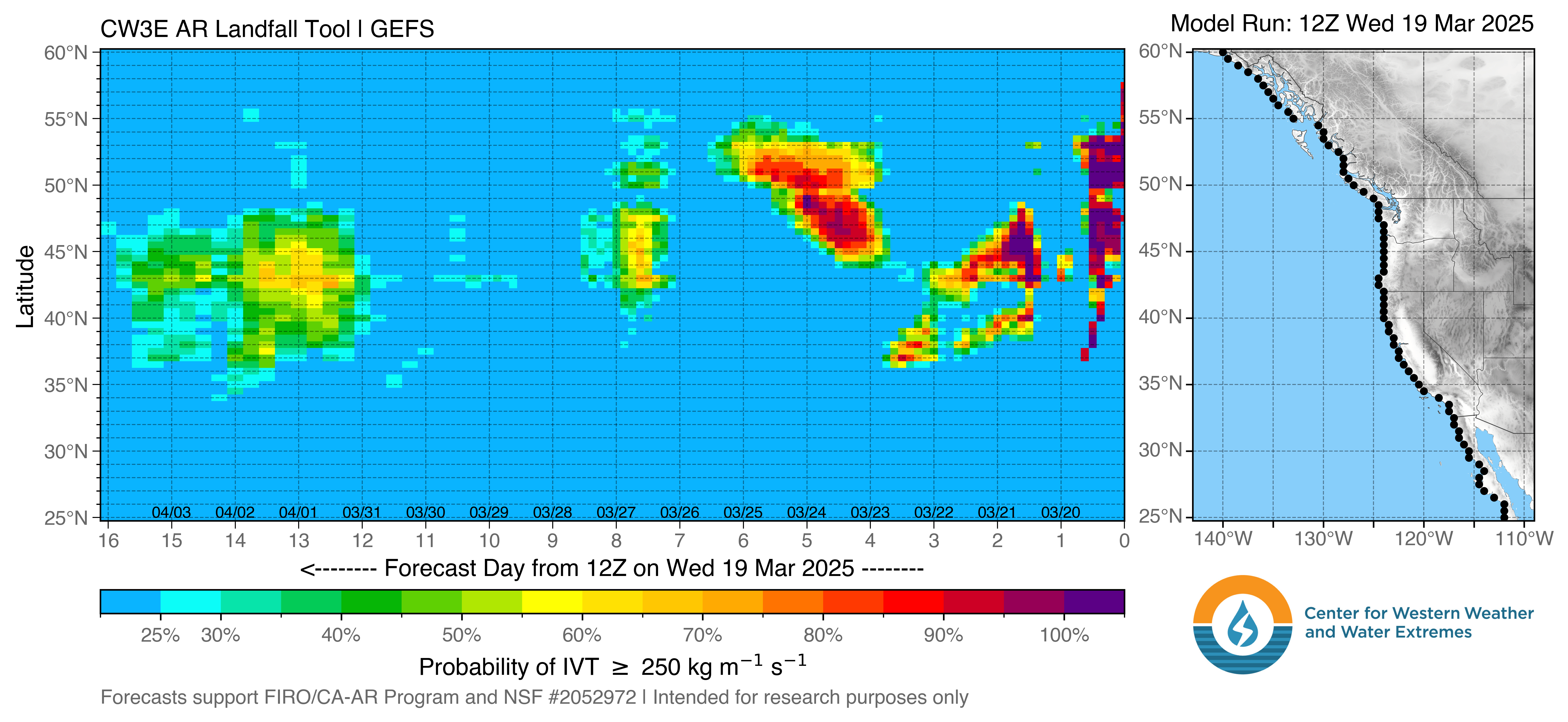
GEFS_LandfallTool_250_coast_current.png (3304×1524)
I shook the magic 8 ball today and it told me don’t be surprised if this winter turns out to be a steady stream of AR storms! Shook it again - bcuz of course i did - and it said 70-80 degrees all winter and very little rain/snow! I hate that thing!! ![]()
Speaking of moisture - 24hr totals sure arent jaw dropping given what sops is getting BUT they aren’t terrible either. ![]()
The big storm some were expecting was definitely a fizzle in the NE part of the state, though things were apparently wetter in the High Sierra from Downieville on south. A bit of modest rain here and there … and that’s it.
NOPS just wasn’t in the bullseye this time & the rain-shadowed-eastside is no joke! I was hoping we’d get more from the wrap-around effect - perhaps that will still happen for some. Checking Radar one last time just now it sure is surprisingly active over allot of the state still! Just not so much in the nops.