AND THIS HERE FOLKS IS WHY WE RESPECT THE *#@$ @anvilhead and the sage advise he gives to our community in this forum.
Personally, I have learned so much here reading your posts. I have ALWAYS suspected the “large thing” in the sky has so much to do with our weather, just never quantified it till now. It makes total sense about the CME have an effect. But reading what you just said and the correlations to amplifying the High Pressures makes total sense. Always suspected “earthquake activity” and the Sun, just didn’t know the science. THANK YOU FOR SHARING YOUR KNOWLEDGE!
I think the cold pool of water off our coast has allowed the NW wind regime to remain dominant.. ushering in cooler air. A lot of discussion about the relative weakness of the HP ridges.. this has allowed the air temps above the surface to remain cooler. The thermal belts have been mercifully cool this summer compared to last year and years past.
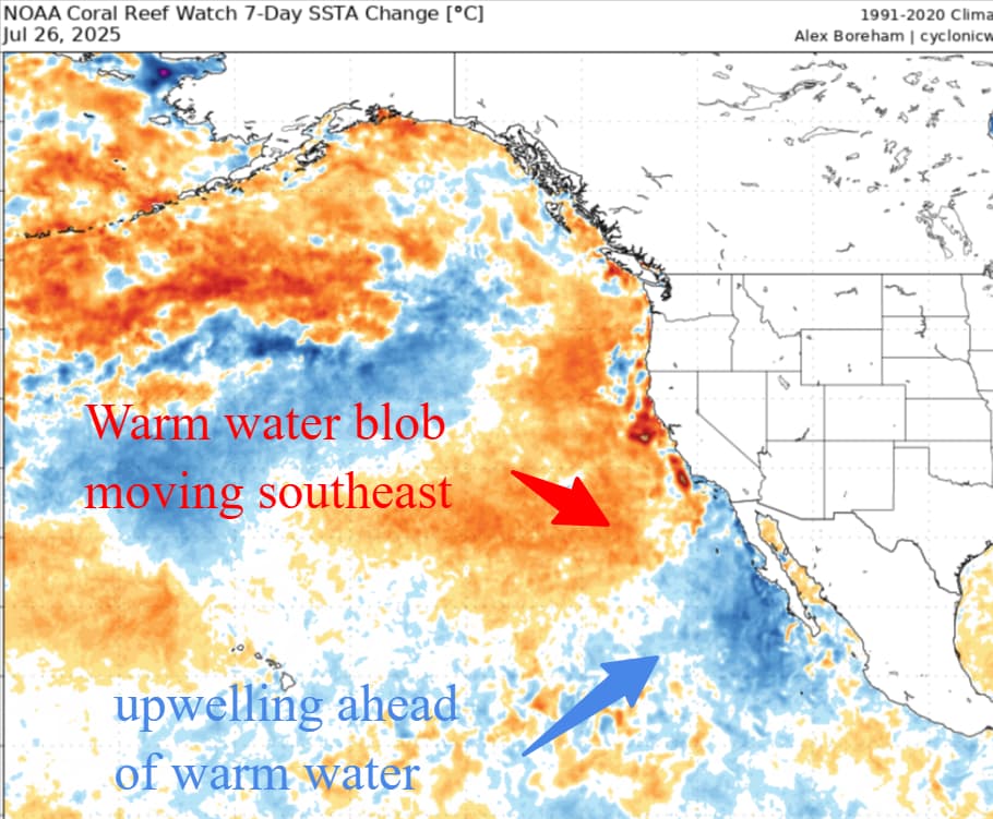
The warmth of the oceans is concerning and mounting.. like a slow rising flood the effects will be long lived.
This am the models were advertising an increasing signal for warmth after 8/4. The trend this year has been to have warmth show up only to have the HP ridge come in weaker and remain transient.
Will be interesting to see if the application verifies and we see our first real prolonged heat wave.
If the ridge is strong enough and long lived enough it may begin to displace some of that cool water off the coast.
This year has been a head scratcher.. persistent marine layer and cool NW winds keeping the upwelling active along the coast. 2009 was like this.. cool summer. We had a lightning outbreak in the north state and a warm spell with it and it got really busy.
This year feels more like a late bloomer. As mentioned below the PNA has remained in a state that has promoted the troughy pattern.
Too soon to make fall predictions but we are beginning to move towards late summer/fall patterns and are now within a month or so of our first offshore wind event.
For now I am enjoying the cool evenings and not running the AC and the lack of activity has allowed a lot of time on the water..
Yes the warm blob of water is promoting rising air ahead of it, leading to troughiness and upwelling along the coast which in turn has led to cold air advection off of the ocean for inland areas when the thermal gradient develops in the afternoon. I am expecting this to end.
I appreciate hearing all of this info and it’s awesome that you folks are willing to share this with everybody. That being said, can someone dumb it down a tad to more of a 290 realm for us end users? Sorry for dropping the IQ of this thread!
On a serious note. The large “Blob” of abnormally warm water in the northern Pacific Basin has the effect of creating a High Pressure area(hot air) this causes the the rising air to create wind as mother nature tries to find balance between the High and Low(Hot/cool) air. With the counter clockwise rotation of the air around the high, it has promoted robust upwelling of cooler Pacific water along the immediate coast line. This is observed with the steep temperature differences from the immediate coast and the inland valleys. Additionally, this has also promoted a longer than avg NW wind each day that naturally occurs between the different temperatures of the inland valleys and coast..
That warm blob of water is on the move in the Pacific. Once the immediate coast line gets warmer(due to increased SST) the differences in temperatures between the immediate coast and inland valley will narrow. This will allow a decrease in NW winds, which will decrease the afternoon sea Breese. This will then allow the natural heating of the inland valleys to increase.
NOW, where does the 4-cornors High setup/end up? Most of the summer it has been centered further east than normal allowing the consistent troughing pattern(low pressue) to continue exiting thw gulf of Alaska and push down the Ca coast. This pattern only reinforces the cooler NW wind pattern.
IF & ITS A BIG IF the 4-corners High moves back to west where it normally lives in the summer months. It will heat up the west coast and open the door for the SW Monsoon season to finally begin as the air rotates around the high.
@anvilhead sees a pattern shift around 8/8. That time frame also coincides with what he described up as alignment with a major sunspot on the surface of the “giant orange thing in the sky”. He referenced this above as well. If this occurs, it only reinforces the High Pressure, allowing it to build even stronger. Where these High and Low Pressure centers end up will be the tell tail sign of what happens weather wise.
Finally, it will be August on Friday and the length of daylight hours in the northern hemisphere continues to shrink, while the earth continues to rotate, lowering the sun angle in the northern hemisphere.
A few additions..
The flow around high pressure is clockwise and counter clockwise around areas of low pressure.
The primary driver of weather for California is the Pacific Ocean. During summer months we experience the land mass warming at a greater rate than the cool Pacific. This drives our diurnal winds each day.
Warm air does rise and cool denser air falls. That is also a function of the diurnal wind patterns.
What has been playing out this year are larger scale pattern shifts which couple sea surface temperatures( SST’s) along with some additional complex patterns of ocean and air currents. Without getting way into the weeds.. the PNA, PDO and AO all are contributors but must be viewed as their relationship to each other.
The MJO is the Madden Julien Oscillation, this tracks convection in the Indian Ocean. Why does that matter for us? That process drives the conveyor belt of moisture which eventually makes it to the west coast. The relative intensity of the MJO can have an effect on our weather 14-16 days after a change is seen in that warm pool of water. We really watch it over the winter as an indication of storminess coming our way. It too is impacted by the other factors mentioned above. The ENSO state is also a player( La Niña and El Niño). However we tend to not see very dramatic effects from the ENSO at this time of the year.
The current hypothesis is that the cooler pool of water just off the CA Coast has been allowing a stronger sea breeze to establish and maintain a stronger on shore flow.
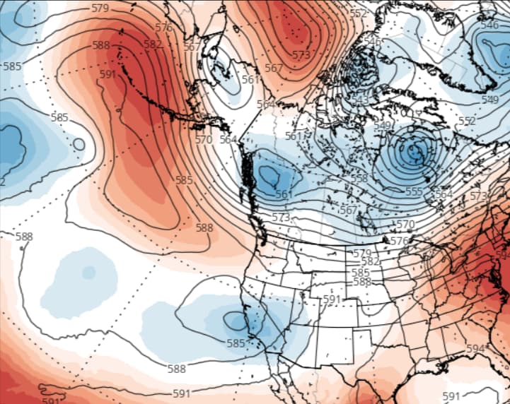
This has been coupled with weaker than average high pressure cells. We look at air in the atmosphere based on millibars.. so 850 mb is where we live, 700 represents the area above 10,000 feet and all the way to 200 mb.. where the jet stream lives.
We look at the strength of high and low pressure areas to guide heat, wind, and cold. When we see a high pressure area of 582 dm.. we see cooler temps.. Right now the models are forecasting some 591-594 dm ridges on or about 8/8. That would translate to temps in the valley of 108 or above. The high pressure we have seen this year has been much weaker and quickly displaced by flat ridges or long wave troughs.. these usher in cooler air.
On models… the models are numerical models run by supercomputers. There are a number of different models with most sponsored by nation states. Our model.. the GFS is a good model.. but can have a warm bias in the summer months. The European model is a really good model but requires a subscription to view.
There are really three versions of models.. the main models which look at singular runs.. the ensembles which are a blend and the high resolution which have a more granular level.
As with anything… garbage in and garbage out. The models rely on soundings and data to coalesce with climate data and all of that is run through a super computer to spit out a run 4 times a day. Again… a lot of really complex stuff. Short version.. I use the Ensembles 7-10 days out for trends.. the GFS and Euro for 3-5 day forecast and the HRR or NAM high res for 24 hours out.
The 500 mb charts show troughs and ridges.. that is a good start.
What is happening.. more lightning this week for the north state.. due to a long wave trough hanging out and a weak area of low pressure spinning energy into CA. This will produce at least several more days of lightning. Some dry and some wet.
After a flat ridge builds in.. and then it does look like a stronger area of HP will build in( possibly) and increase the heat.
Way too far out to hang your hat on.. so more of the same through the end of the week and then gradual warming and drying and then we will see what happens.
Do not forget the “Butterfly Effect”. Somewhere right now a butterfly may flap its wings and the air current it creates may travel outward and change everything.. That is what is great about weather… as far as we have come..we are still caught off guard by it.
No single rain drop feels it is responsible for the flood…
My first fire season was 77 we started at Mt Diablo ended up on Scarface and Pondosa the lightning hit on 8/3. Burned a engine up at Mt Diablo I think the rest of TCU ended up on Marble Cone it was a long month
I was saying that the coronal hole is going to be earth direct in the next couple days if it survived another rotation.. and the high-speed coronal solar stream would be arriving around the timeframe of 8/6. We don’t want to derail this thread though.
Oh boy “it” needs it’s own thread 100% - but, imo - it might be way too much for way too many to deal with/see the connectivity between earth Wx, Solar Wx, Galactic Wx and/or the Cosmic Wx forcing that is driving everything as we speak. I’m just an idiot/stooge and i can see how the conversation would go astray quite easily. Back to regularly scheduled programing..