One of top producing rain amounts for the month of April here in Cali. Keep enjoying the lovely weather at home.
Super El Niño coming. All data pointing to wet weather, lightning and heat domes.
What’s all the super El Niño about??
Yes please. I can’t get my head around the Ninos..
So wetter season with higher RH recovery’s with heat domes in between? I understand that.
This is how it was summed up for me from a local weather nerd, I by no means pretend to know anything about weather forecasting or predictions, just passing along what was sent to me:
California El Niño Outlook: Summer 2026
There is a growing chance that a strong El Niño could develop this year. While some are calling it a possible “super” El Niño, that is not guaranteed. Here’s what it likely means for California this summer.
Warmer Than Normal Conditions
Summer 2026 is expected to be hotter than average, especially in inland areas like the Sacramento Valley. This likely means more frequent heat waves, higher daytime temperatures, and warmer nights with less cooling.
Reduced Coastal Cooling
Warmer ocean temperatures can limit the formation of coastal fog. With less fog, coastal areas may see hotter days and warmer nights than usual.
Occasional Humidity and Unusual Weather
Unusually warm ocean conditions could introduce periods of higher humidity and occasional moisture moving up from the south. While not constant, this could bring brief stretches of less typical dry summer weather.
Fire Season Outlook
Fire risk remains a concern. Hot temperatures combined with dry vegetation can increase wildfire potential. While occasional moisture may provide short-term relief, it is unlikely to significantly reduce overall fire risk.
Important Timing Note
El Niño typically begins developing in the summer but reaches its peak during the winter months, usually between November and February. This means the most significant impacts are not expected during summer.
Looking Ahead
If El Niño strengthens, the most noticeable effects for California would likely occur in winter 2026–27. This could include increased storm activity, heavier rainfall, and a higher potential for flooding.
Bottom Line
A strong El Niño is possible, but not certain. For summer 2026, expect warmer conditions, reduced coastal cooling, and occasional unusual weather patterns. The greatest potential impacts, however, would come later in the year during the winter season.
El Nino is defined as SST Temperature greater than
.5 centigrade (.9 Fahrenheit). Between 120W-170W in the Eastern Pacific +/- 5 degrees from the equator for 3 more months.
SST .5-1.0c are normal El Nino
SST 1.0-1.5c are moderate El Ninos
SST 1.5-2.0c are strong El Ninos
SSR 2.0C + are Very Strong to Historic El Ninos.
Current models show a moderate to historic El Nino in the Nov 26 to Jan 27 time fram( 2.0-2.6c or 3.6-3.9f) But as stated previously, A LOT CAN CHANGE.
The entire Northern Pacific Ocean is between 1-3f above normal with some pockets immediately offshore from California as much as 5f above normal. Hence the reason for the late season rain and low snowfall totals.
In SoCal during strong El Ninos, the days are hot, the nights get little recovery and the SW Sea Breeze is almost non existent. The pelagic fishing is off the hook (Wahoo withint 30 miles of San Diego) all the Dorado you can handle if you can find bait. With immediate beach water temperatures approaching 75-80f( hence the reason no sea breeze)
My old man spider senses tell me this will be my “34th worst fire season ever” provided we get the starts..
CHEERS🤣
I don’t believe you, that not what Grok told me Hoss.
I always explain that the Nino state of our oceans is a statistical explanation of the sea surface temperatures. The results of our “ENSO” conditions are really hard to predict. We saw a strong El Niño in 1997-98 with heavy rain and snow, and then 2015-16 with another strong El Niño where we had a dismal precip year but with the expected warmer ocean temps.
This one seems to be tracking into a very strong or “Super El Niño” event. If we look backwards we can see that often strong El Nino’s favor warmer temps and increased precipitation for Southern California and below normal precipitation for Northern California. The opposite would be expected for a La Niña. The dividing line for North/South… is really around the 80/50 corridor but a La Niña does not mean SoCal will not receive heavy rain events and conversely an El Niño can bring strong rain events to NOPS… as was the case in 98 and other El Niño events.
The challenge occurs when we experience outcomes that do not match expectations. Example.. an overly warm winter for much of the state this last winter during a La Niña and below normal precip for the PNW.
This year has another anomaly.. Sea Surface Temps have been running higher for the last year. That can change everything. This affects everything from convection to surface pressure to warm air advection which can enhance cloud development and stifle the normal diurnal flow that we experiment.
I really think this year will be hard to predict from a large scale pattern perspective.
A butterfly somewhere decided to hold a masters level weather course this year.. will be interesting to reflect next April..
Like sands through the hourglass, the temp roller coaster.. rolls on!
Funny how those lurking 80’s keep persisting this winter/spring.
#GiddyUp!
#shiftingbaselines
Edit: May 3, 2026.
Shhh, you hear that sound? Thats the sound of 90’s marching this way..
#gameon
#shiftingbaselines
All I see is 50 degree weather and an inch of rain between today and tomorrow but what do I know 
Then comes some nice warmer weather next weekend.
Patience young Padawn.. You’ll see.
May the 4th be with you & us all! 
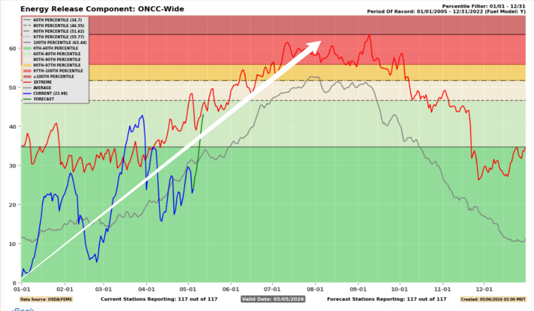
A good example of what I mean by hydroclimatic whiplash and why you have to look at the trend line. The compartmentalization into more of a “fire episode” rather than “fire season” based on the huge swings in the weather. The huge down swings in ERC/upswings in LFM basically prevent lower intensity fire which would be beneficial and eliminate vegetation that could provide more intense fire behavior later in the year, and if the trend continues the entire system will eventually get to a reset point.
Cooling trend a week after the heat wave. Enjoy!
Hmm, incoming “cooling trend” to numbers that are still above seasonal averages. Seems like barely any cooling and certainly not a trend. Unless we’re talking about that persistent above average heat trend.. 
Hmmm I didn’t know going from 85 degrees tomorrow down to 71 degrees Wednesday here in Northern California wasn’t considered a cooling trend. But what do I know…..
Forecast models are in really good agreement that a shortwave will move through North ops ~ Wednesday and this will break down the ridging, as the shortwave moves east the ridge rebuilds towards the end of the week. As the ridge rebuilds it is tilted to the surface high pressure in the great basin. The satellite low pressure/shortwave phases with a larger trough and this will bring the chance of stronger offshore flow and compression aided heating depending on where it ends up phasing.
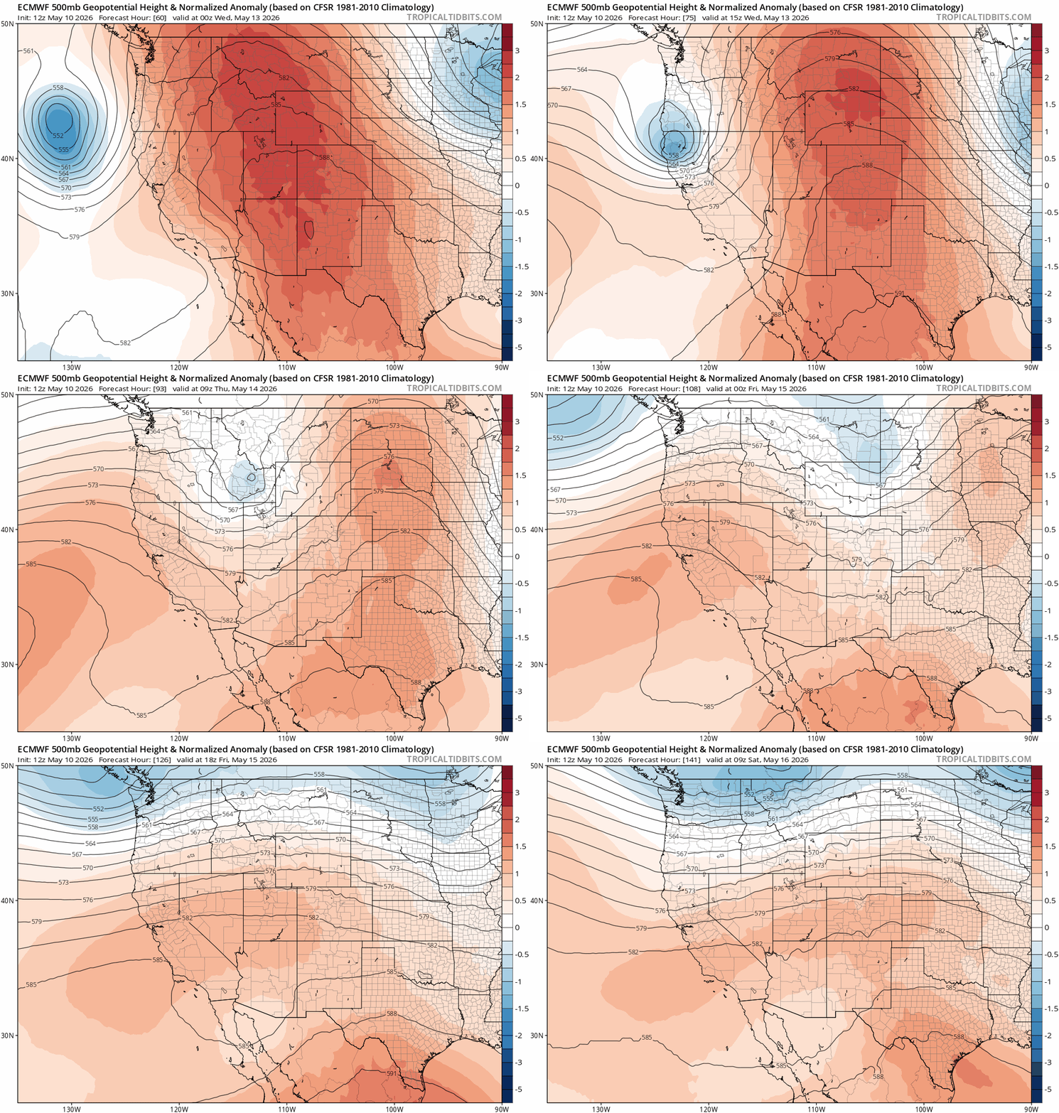
Translated to English: good chance of offshore flow and heat west of the mountains later in the week/weekend, with a chance of some offshore winds to really compound the drying.
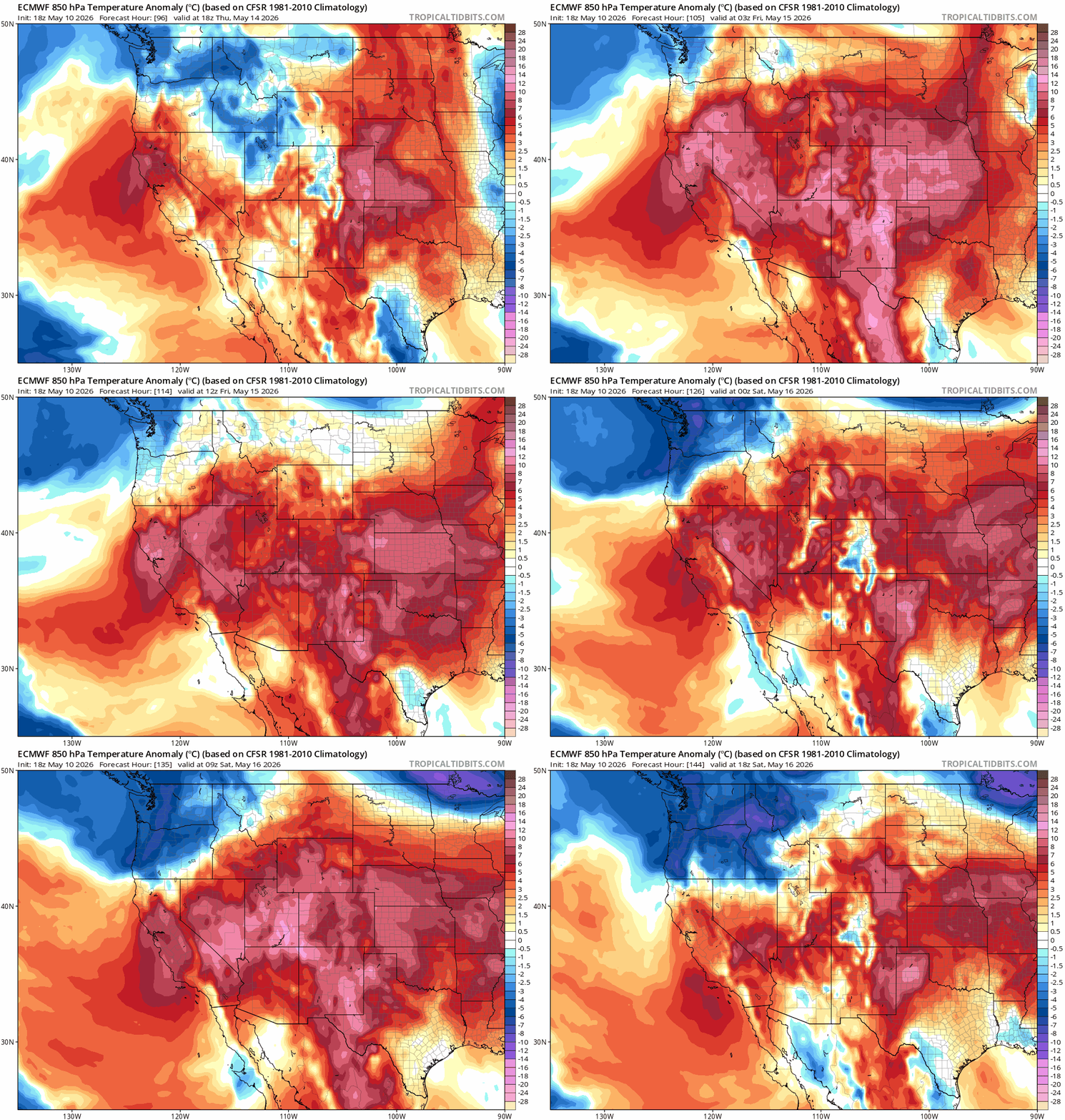
Classic looking offshore pattern as shown in the 850 MB temperature gradient.
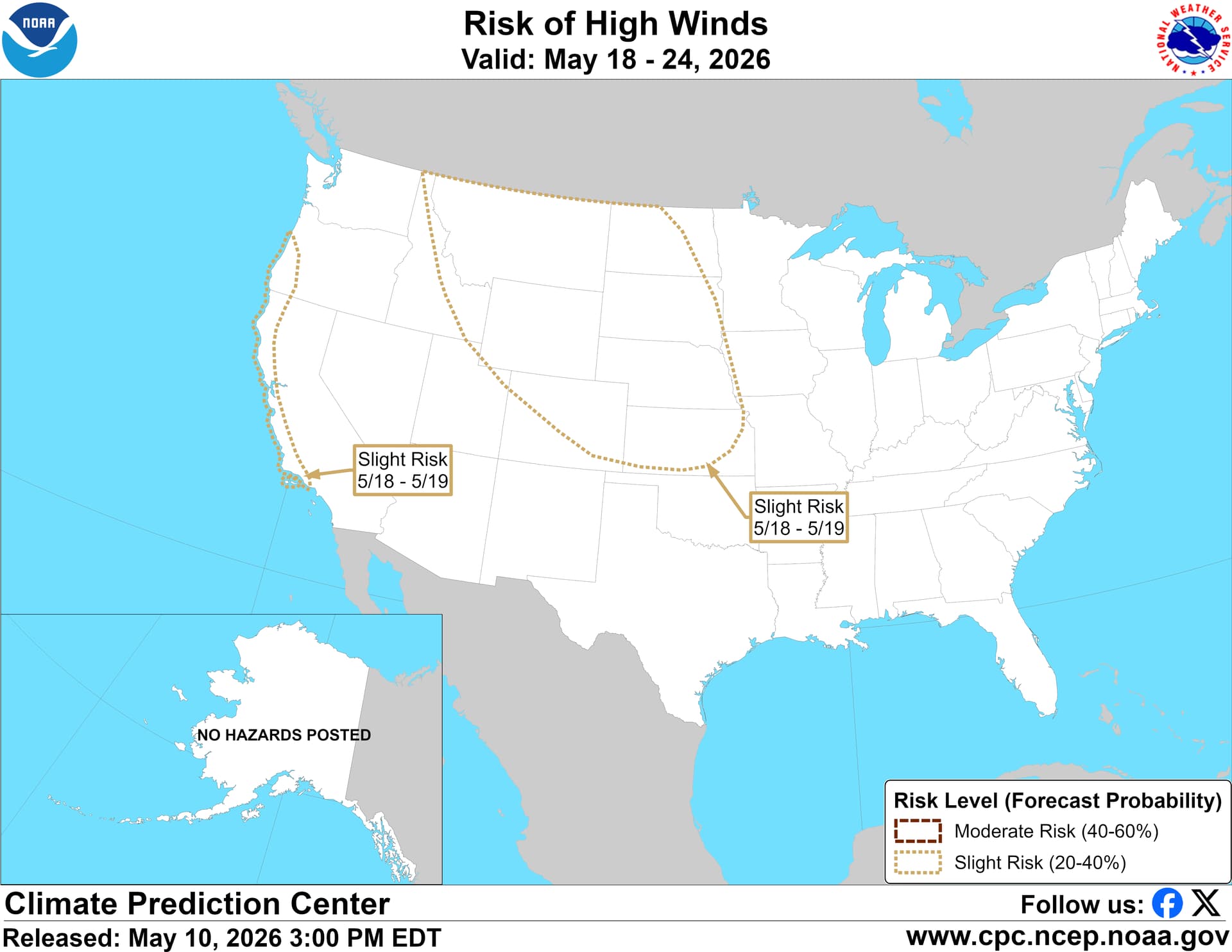
Slight risk of gusty winds highlighted in the CPC experimental outlook: