http://www.alertwildfire.org/sdge/index.html?camera=Axis-Lyons1&v=81e002f
good shot of buildup coming up from the South.
http://www.alertwildfire.org/sdge/index.html?camera=Axis-Lyons1&v=81e002f
good shot of buildup coming up from the South.
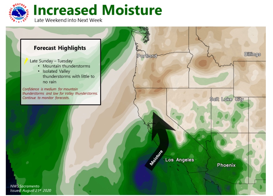
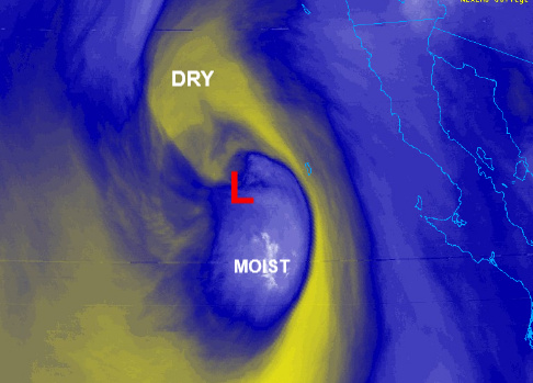
This is trophospheric folding. Moisture and dynamics from Genevieve’ remnants mixing with very dry upper air. We will have to see how this manifests when thunderstorms form.
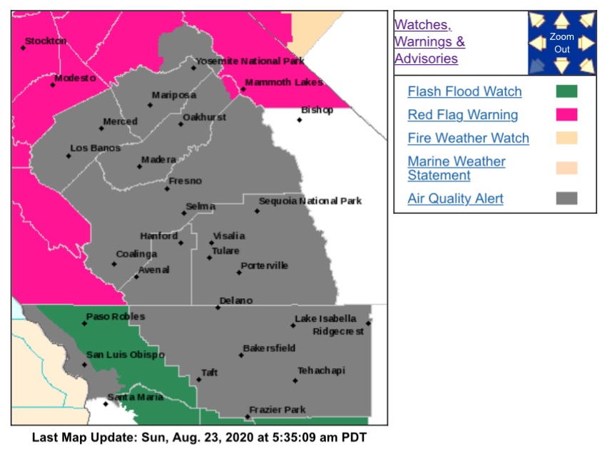
Regional Forecast
Forecast Discussion
https://www.weather.gov/wwamap/wwatxtget.php?cwa=sgx&wwa=all
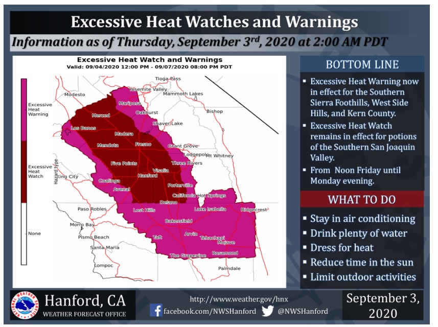
Central Valley
Forecast Discussion
https://www.weather.gov/wwamap/wwatxtget.php?cwa=hnx&wwa=all
From Dr.Swain of Weather West Blog…one hour ago.

Weather Westan hour ago edited
I woke up this AM and checked the models to see if they had backed off their strong dry lightning signal for late this PM and tonight.
Unfortunately, they have not.
Here’s is Nick Nauslar’s perspective from late last night (formerly fire weather forecaster at SPC; now specifically at NIFC). He is concerned there could be hundreds of new lightning fires by Tuesday.
So far no lightning strikes. I think what is going on is the low pressure system is moving a bit slower than anticipated. Forecast models showed convection already entering Northern CA at this timeframe on previous runs. The low pressure also is more negatively tilted (E-W flow rather than S-N) than depicted on models. This could mean the area of low pressure is a bit stronger than forecasted. Originally the lightning event was set to begin tonight, but models sped up the timing to last night and were obviously too fast with the timing. Forecast models are awful in handling these situations, there isn’t enough data and a lot of variables.
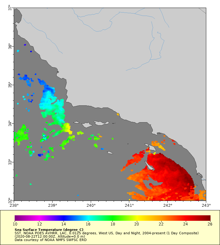
For example check out this satellite estimated SST, some areas are over 80 degrees. Will have to just watch and see what happens.
Red flag warnings indicated 11pm tonight as start time
Started at 5am in Santa Cruz County
Now appears all my NWS alerts are 11pm 🤦🤦
Regional Forecast
Forecast Discussion
https://www.weather.gov/wwamap/wwatxtget.php?cwa=sgx&wwa=all
Central Valley
Forecast Discussion
https://www.weather.gov/wwamap/wwatxtget.php?cwa=hnx&wwa=all
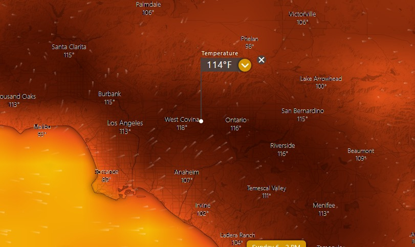
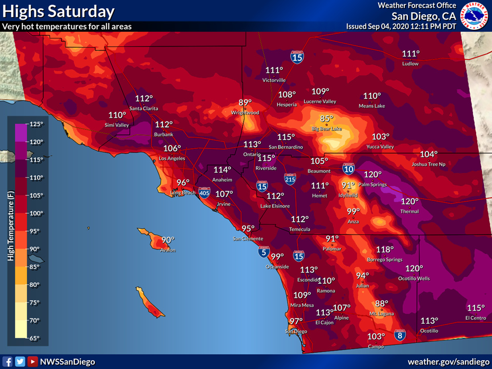
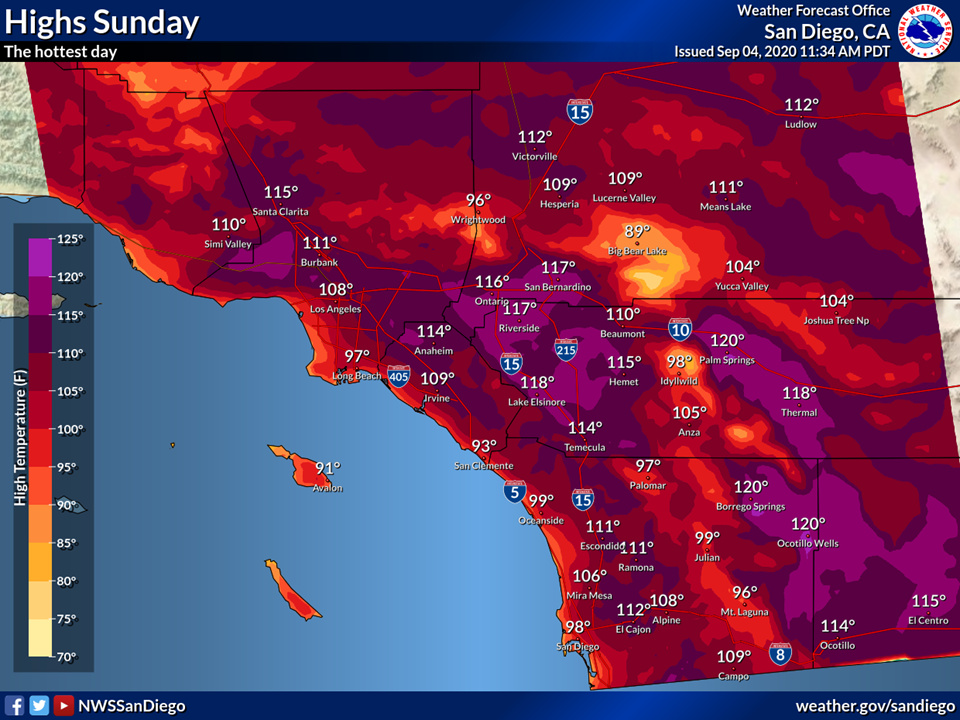
NWS Los Angeles says that due to high pressure overhead and a very potent trough over Montana causing surface high pressure over Utah… offshore gradients that day could combine with strong high pressure to cause the hottest calendar day on record in many areas.
And from NWS San Diego:
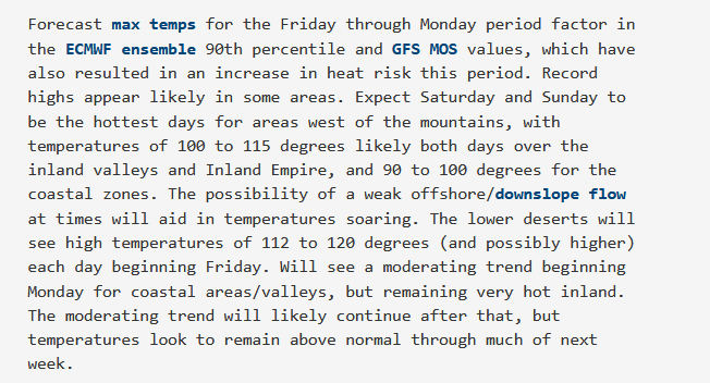
ECMWF for Sunday:
00z run of the ECMWF would usher in this ‘hottest day ever’ on Sunday, immediately followed by an extremely rare early September ‘moderate’ Santa Ana wind event Tuesday and Wednesday.
Regional Forecast
Forecast Discussion
https://www.weather.gov/wwamap/wwatxtget.php?cwa=sgx&wwa=all
Central Valley
Forecast Discussion
https://www.weather.gov/wwamap/wwatxtget.php?cwa=hnx&wwa=all
Oh boy, 2020 just keeps getting better! 
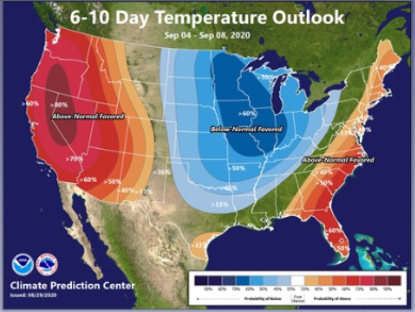
Live Fuel Moisture;
I’d imagine these numbers will look significantly different next week if the heatwave & wind event materializes as forecasted for this weekend… 


Santa Ana update: 9/8-9/10
ECMWF has LAX-DAG gradients around -6 to -7 Tuesday night into Wednesday. GFS and NAM peak around -5. There is some upper level support.
A blended idea of these models would support NE winds 15-20 MPH with gusts 35-40 MPH in the windiest typical areas. RH would be in the 5-10% range.
We will call this a weak-low end moderate Santa Ana wind event at present, with extremely dangerously low RH and high temperatures. I’d expect critical delineations from SPC.
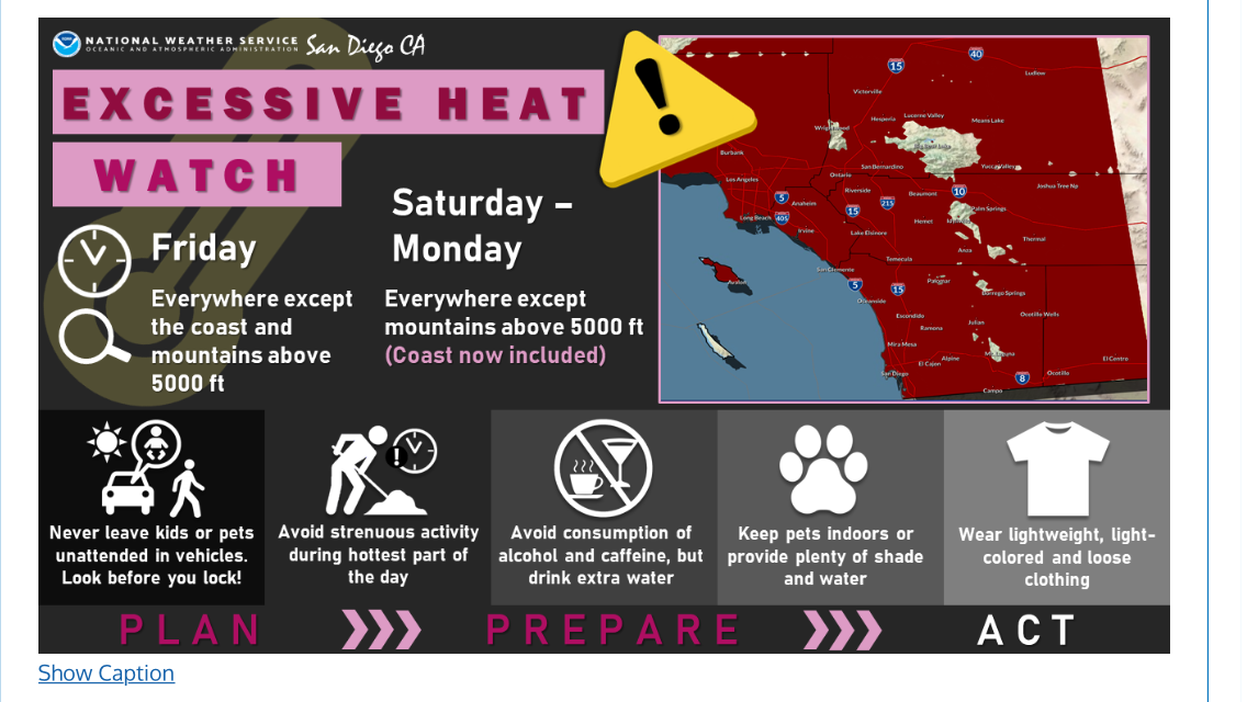
From NWS San Diego: [
Excessive heat and daily minimum [RH] of 15-20% will elevate fire weather conditions across all of SoCal this weekend. Coastal foothill areas may reach critical fire weather conditions for several hours each day, particularly in San Diego County. By mid-to- late morning on Saturday, east winds of 15-25 MPH with local gusts 30-40 MPH are possible. Those winds are forecast to weaken by Saturday evening, but could get gusty again on Sunday for several hours.
NWS San Diego has upgraded FWW’s to RFW’s for San Diego and Riverside county valleys and mountains. Main impact will be Saturday afternoon. With the holiday weekend things might be interesting
High Risk days added for SoCal for Wednesday. Temps in the 90’s gusts to 50 and RH 5-10%. Not a good set up so early in September for sure.
add…my link for the San Diego Snooper is broke. Can anybody send me the new/correct one. LA still works fine. TIA