Decent storm cells rolling through the inland empire this hour.
4 Likes
Let’s add a mid summer grass crop to make things even more interesting, I suppose.
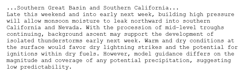
Discussion… as I had predicted before the season began, the monsoon high pressure system has been stronger and earlier than forecasted. Over the next 2 weeks there should be more chances of widespread monsoonal moisture.
The precipitation received across Southern Operations area should be sufficient for a small grass crop to develop, but insufficient enough to stall fire season due to the extremely dry bulky fuels and long days. Any grass crop should cure very quickly in the intense sunshine and heatwaves that follow. This should provide additional fuel for large fire activity rather than reducing the risk of large wildfire.
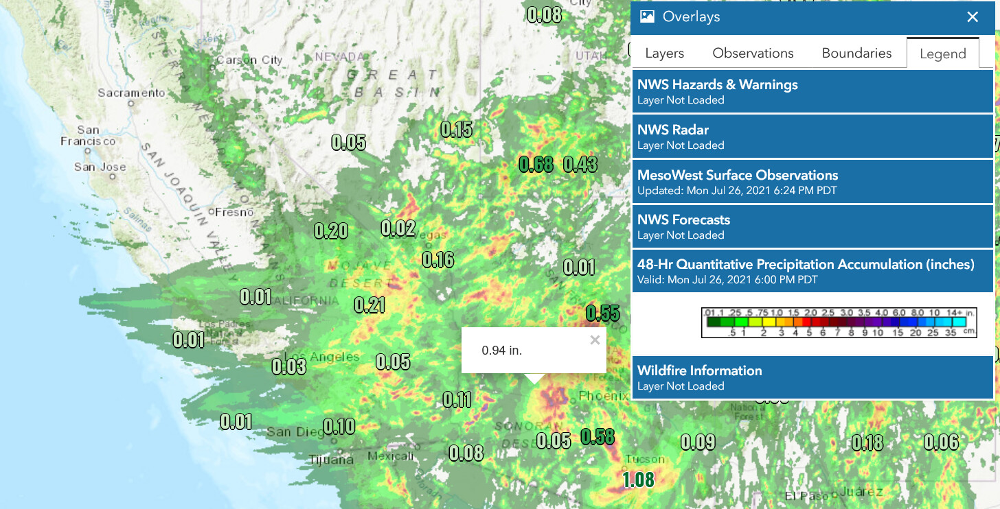
48 hr precipitation analysis
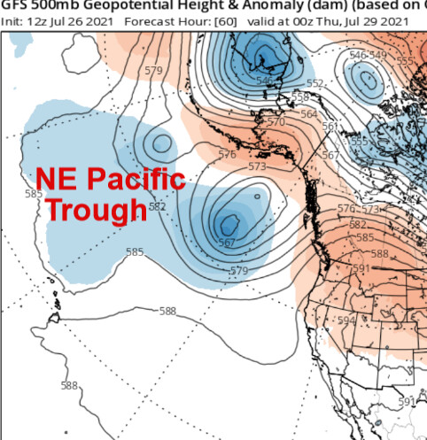
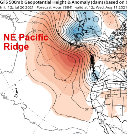
About mid August we should begin to transition the monsoon high pressure system over Nevada to stronger high pressure over California, cutting off the monsoonal moisture. This is evident at the end of the GFS model runs, which shows a transition from the dominant subtropical high pressure system to the NE pacific ridge.] This transition would begin about two weeks early.
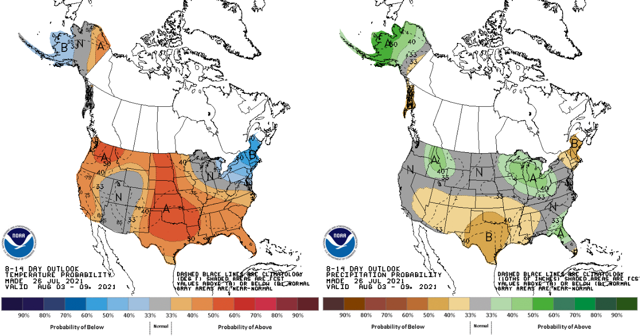
This drying can already be seen in the CPC 10-14 climate outlook, showing drier and warmer weather as the transition may begin.
This would potentially allow for much warmer and drier weather in the middle of August as the center of the ridge oscillates over CA heading into September. The intense strength of the upper level high pressure system this year could mean that we see more intense heatwaves, similar to the September 6th heatwave of last year where Woodland Hills reached 121 degrees… if not something potentially even more impactful.
15 Likes
Flash flood watch in effect for the Central and southern sierra.
https://forecast.weather.gov/wwamap/wwatxtget.php?cwa=hnx&wwa=flash%20flood%20watch
5 Likes
BDF getting hit pretty good with lightning around Big Bear
1 Like
Assuming moisture with that?
Appears to be based on visual and what radar is showing
Just a little overview of what the GFS shows for the next week for the entire area in general.
A heatwave continues for Southern CA through Thursday. Temperatures reach 120 in the deserts and over 100 in the inland valleys.
On Thursday a crisp shortwave moves into Central CA and sets up onshore winds, then two more shortwaves moves into the Pacific NW and continue the onshore winds through Tuesday of next week. Fire danger elevated!
What is less certain is yet another shortwave in the hard to forecast time window of 8-10 days, which drops into the Great Basin, and helps build a strong ridge that would bring an unbelievable large and strong ridge of high pressure to the entire state, plus the Pacific NW in what looks like another 1-500 year event for that area. The GFS takes this into the Great Basin while the EC takes it as an outside slider, which is far fetched for this time of year.
The GFS has been very consistent and the timing makes it perfect as it is in the natural reamplification cycle of the high pressure system. To further complicate matters is the presence of tropical moisture and shortwaves rotating around the high pressure system later this week. Stay tuned…
The sequence of weather events for the northern part of the state and Pacific NW is unbelievable if it pans out. There has been tens of thousands of lightning strikes from Northern CA into the Pacific NW, moderate to strong onshore winds could lead to explosive fire growth on any new lightning fires, and a potential major heatwave would exasperate those conditions.
I am noting this in South Ops because you can expect many resource requests from South Ops if the following sequence comes to fruition.
12 Likes
Some thoughts on South Ops weather
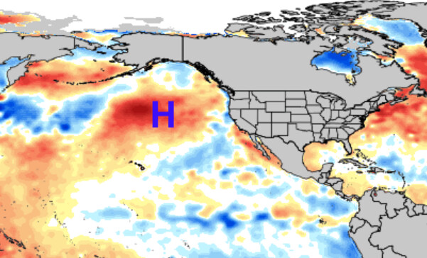
The North Pacific ridge of high pressure is the dominant feature, extending much further north than usual. This is destabilizing cold air from the north, and extending it further south downstream into the upper Great Basin. These surface cold fronts are anomalously early. After a very strong subtropical high pressure system dominated the weather over the SW, centered on average over NV, this feature is sending cooler weather in the form of dry shortwaves across the northern part of the state which is deepening the marine layer all the way into South Ops and keeping onshore winds gusty.
The subtropical ridge should begin to rebuild into the area later this week, for warming temperatures and possibly a return to monsoonal flow. The last week of August into the first two weeks of September is the time period of greatest opportunity for widespread dry lightning events from the ocean, as both of the high pressure centers I mentioned will be near the same strength, with a split in the middle, and the monsoon trough farthest north east. One more lightning event could be catastrophic for the state and west in general.
A hazard to watch out for next month is the presence of the surface cold fronts already extending south into the Great Basin, this could turn gradients offshore and lead to the maximum heatwave of the year west of the mountains.
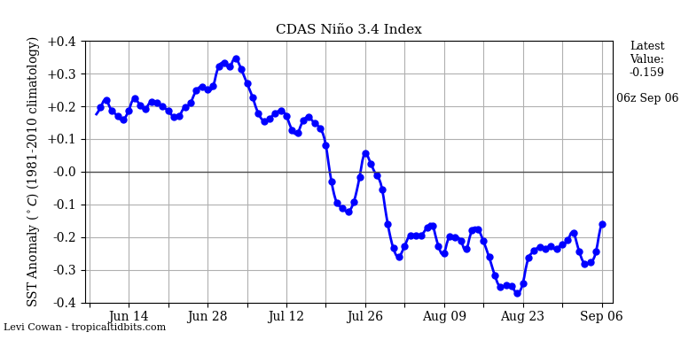
The anomalously strong North Pacific High pressure system has significantly warmed the SST in the area it is located, and thus I expect it to continue and be a dominant feature as it migrates slightly east. La Nina is expected to continue to develop as Nina SST anomalies are at -.04 c, and this will likely bring a very dry fall for Southern CA, as persistent strong high pressure continues across the NE pacific, a long wave trough over the Northern US, and as is evident of the surface cold fronts ALREADY entering the Great Basin, and the anomalous subtropical ridge takes its time to wind down fully.
Continued extreme swings in temperatures can be expected as highly amplified weather plagues the US. Sea surface temperatures off the CA coast have warmed to above average and this increases the chance of stronger offshore winds in the presence of the right ingredients in the Great Basin.
Expect continued hot temperatures inland, large temperature fluctuations, an active monsoon during early September, the highest temperatures of the year possible west of the mountains by mid month, followed by a possible early offshore flow pattern by the end of the month as the North Pacific high becomes the dominant feature again.
SST anomalies

Strong surface cold front digging into the upper great basin next weekend with stronger ridging to the south.
As always, please use Southern Operations and NWS forecasts as official information and my thoughts as supporting data.
10 Likes
Any updated info on possible downsouth lighting probabilities?
That could really throw a wrench in an already stressed situation.
1 Like
Forecast is very difficult with respect to Nora entering the picture. Periphery moisture should lead to increasing thunderstorm chances with isolated dry lightning strikes. Models do not show much of an upper level trigger through mid week which precludes widespread lighting hazard.
The GFS is adamant about a cut off low pressure developing off the coast at the end of the first week of September with very strong high pressure across CA. This would be the setup to watch.
Cannot forecast any of this until Nora and Ida make it clear where they go and how strong they get. Of extreme interest, last nights ECMWF run has Nora getting picked up by a trough which causes baroclinic forcing and a legit tropical storm moves into AZ.
8 Likes
Looking around today… appears things are still trending towards a repeat of the start of winter…
https://www.cpc.ncep.noaa.gov/products/analysis_monitoring/enso_advisory/ensodisc.shtml
4 Likes
Santa Ana wind forecast. I am going to go over bullish and bearish indicators for Santa Ana wind season.
Persistent Modoki La Nina: bullish
Developing La Nina could favor less troughing over the West coast, but also more split flow as high pressure remains strong across the North Pacific.
Sea surface temperatures off the CA coast: slightly bullish
Depends on if SST stay above normal or not. A major heatwave through the middle of the month could keep SST above normal. Above normal SST means lower surface pressure at the coast for stronger gradients, and more upwelling potential by offshore winds.
Longwave trough over the Northern US: bullish and bearish
The persistent longwave trough over the Northern US could mean stronger surface cold front and upper level support into the Great Basin this fall if it persists, but it could also mean less individual events and favor longer duration wind events.
Strong high pressure/warm water over the northern Pacific: bullish
Persistent blocking could lead to more of an inside track on storm systems, and the increased strength could mean more amplified and energetic events
Above normal temperatures in the Great Basin: bearish
The surface absorbs heat and the heat takes a little while to mix out before surface cold fronts reach their maximum ability to create strong gradients, it could take a couple more weeks than normal for the surface to cool in the great basin due to the persistent above normal temperatures
I am forecasting about normal offshore wind events, but a 25% increase in maximum strength and duration by mid fall.
12 Likes
What will become Hurricane Olaf could pose a high risk for elevated convection next week as the mid level remnants interact with shortwaves over the Pacific Ocean. The flow will turn out of the east in the mid levels but there will be divergent flow from the South and west as the storm interacts with a shortwave(s). As the moisture moves over the Pacific ocean with much drier low levels, and over a very warm airmass the divergence plus these factors favor elevated convection with dry lightning.
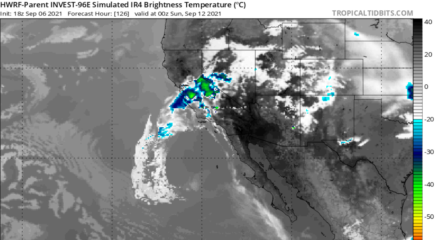
What is difficult to forecast is the exact track of the tropical cyclone, the placement of shortwave(s) around the high pressure system, and exact convective outbursts.
Stay tuned.
9/8 tidbit.
A mid level circulation from an easterly wave could trigger elevated convection today in San Diego county. This feature is going to move north west and interact with a trough which could lead to the widespread lightning event in the northern part of the state tomorrow night.
Olaf has trended slower and a bit further south. Will continue to monitor it’s remnants this weekend.
8 Likes
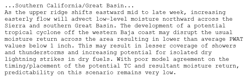
From NWS San Diego
Really high CAPE values for Southern CA today. The fast storm motion and dry sub cloud layer will likely bring a chance of dry lightning strikes.
4 Likes
So far the storms in the High Desert, Apple Valley, Hesperia and Victorville, have a lot of rain to accompany the lightning. There are some strikes that are popping outside the rain boundary but then the rain comes through and soaks it all…fingers crossed nothing gets started.
6 Likes
Got some strikes on the west side of Kern county.
https://www.lightningmaps.org/
2 Likes
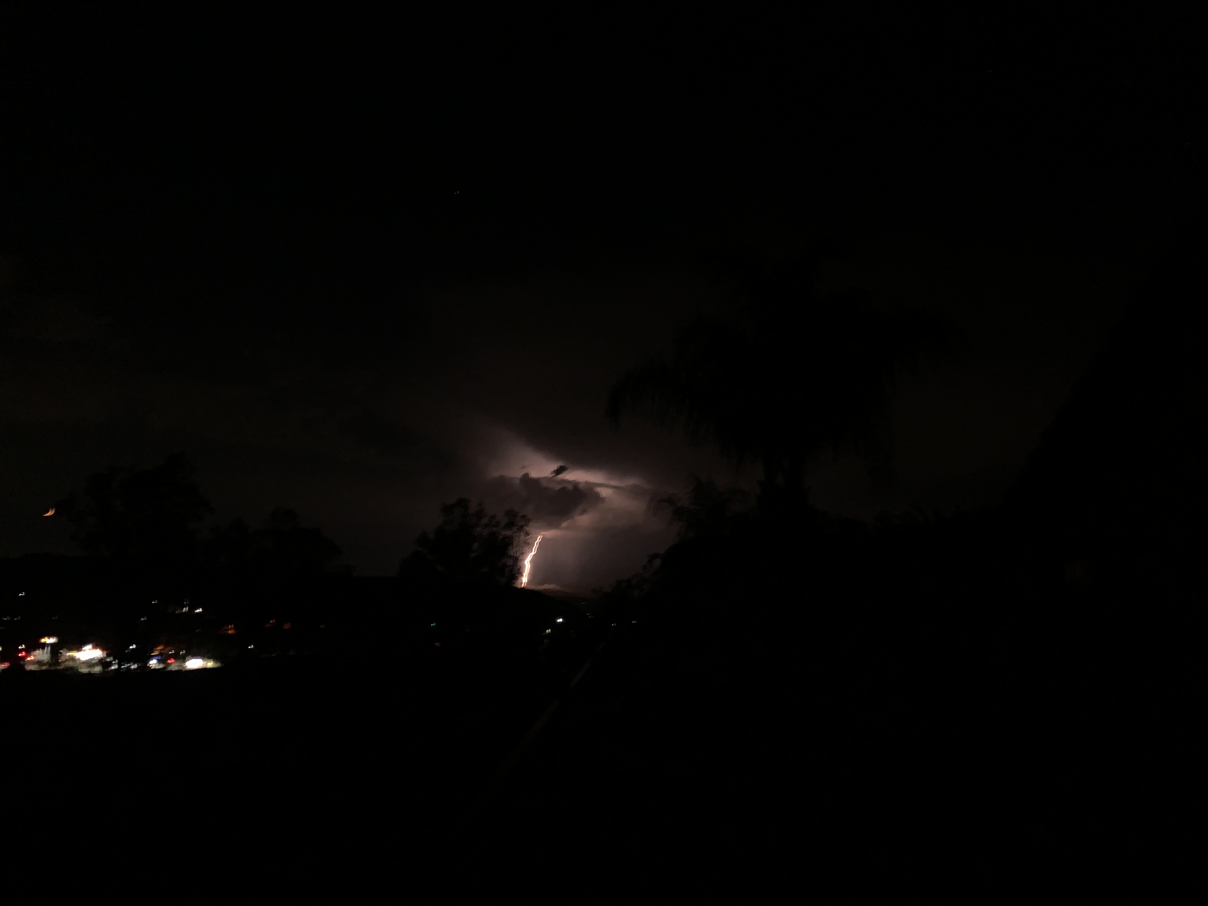

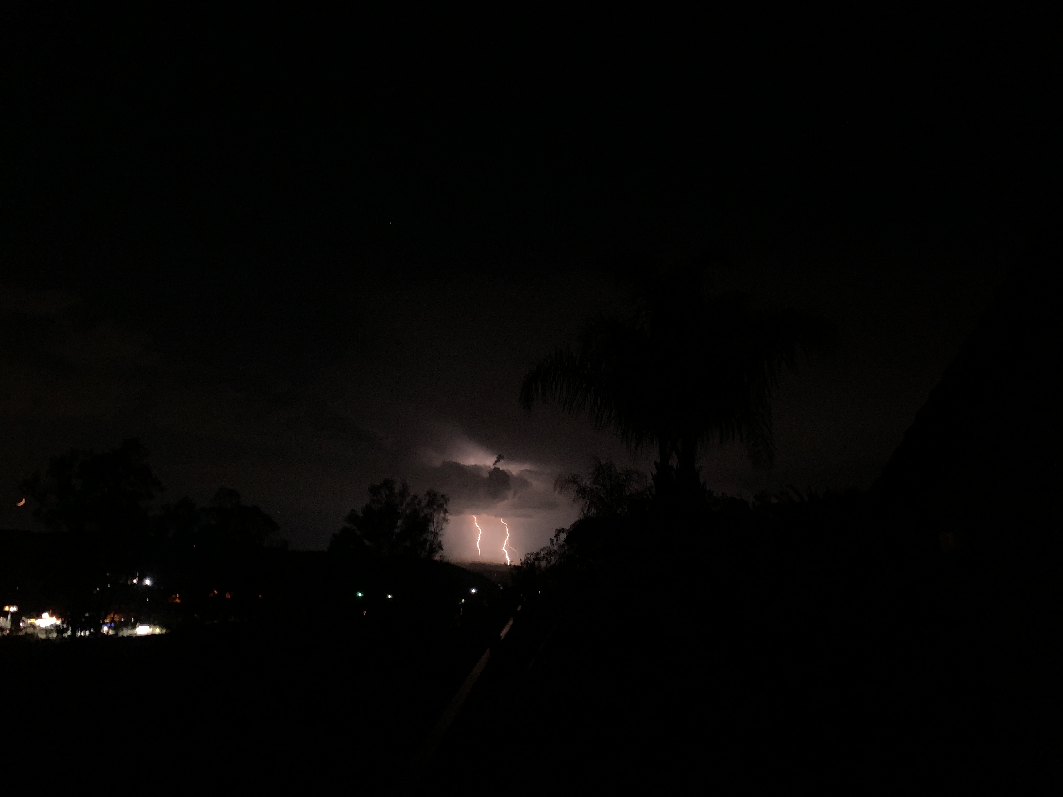
A lot of lighting west San Diego County moving NW.
Started just before sunset over SD City. A lot of CG’s
8 Likes
This is the group that will go out over water and come in over San Luis/Monterey area, again dropping more C to G lightning I am betting. Good shots’s Chief!!!
2 Likes
Solid downpour here in Twain Harte. Glad my gutters are clean.
4 Likes