South Ops Weather - 2022

Forecast models peak LAX-DAG gradients at an average of -3.5 and this will set up weak to moderate offshore flow for tonight into tomorrow. The offshore flow will dry things out and begin to cure the grass crop that has developed from recent rainfall. Fuel receptivity will vary based on areas that are solely receptive mature fuels vs the mixed in grass crop.

A series of inside sliders will reinforce the offshore flow through November and this will promote significant drying and varying offshore winds. The GFS and EC show a potential crook in the jet stream the first week of November that could bring strong Santa Ana winds but it is a bit too early to forecast the event. The general consensus on the models is drying, offshore winds, and increasing wind potential as the Great Basin continue to cool after the extended summer kept offshore winds away.

9 Likes

this is almost 30 .days old. there has been some moisture since that post and a lot of drying. will be interesting in the new update this week. still dry out there…be safe out there…with projected wind events, fuels are still receptive to carry fire big time and winds will make fixed wing attacks less than desired

4 Likes

Pronounced drying this morning with the offshore winds.

Forecast models bring another round of offshore winds for Thursday night into Friday. The trough has less cold air and is too far to the east for upper level support so there won’t likely be advisory level winds, but continue drying will occur.

6 Likes

4 Likes

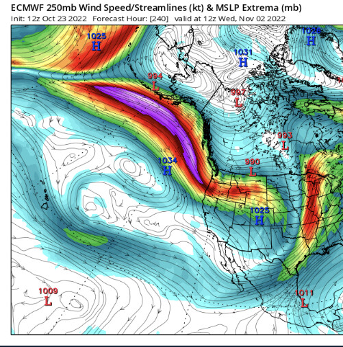
Forecast models drop a very cold storm into the Antelope Valley on Tuesday. Light rain and snow will occur due to upslope flow. On Thursday, a 140 knot jet around the low pressure system sets up around the San Gabriel mountains which could produce a mountain wave event for the LA Basin.

This sypnotic setup has the possibility of producing very strong winds in areas that typically do not receive strong offshore winds.

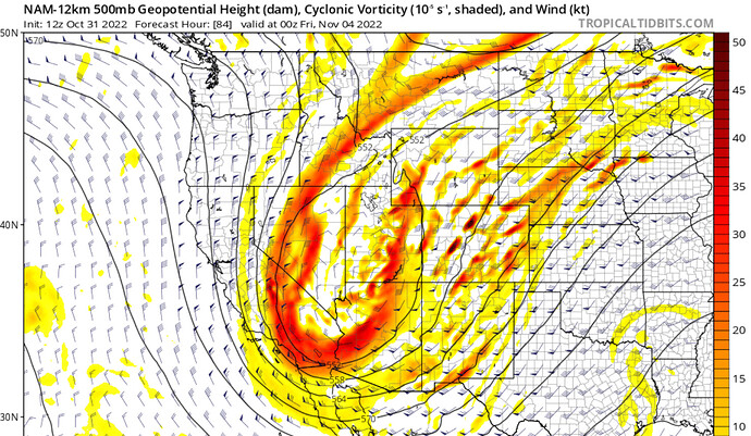
Surface high pressure will build in behind the trough, and this will produce some offshore winds across Southern CA. Models diverge on a second trough, which is colder and more powerful. Depending on the model run and model, it sharpens into the Great Basin or stays longwave to the north. Either way, this is one of the coldest troughs on record for such an early date in this part of the Western US. If it sharpens, it would set up a strong Santa Ana wind event. Will continue to monitor.

11 Likes

lets hope this coming week raise the numbers

Hurricane hunters are investigating a developing atmospheric river over the North Pacific. Hopefully this data will help in final rainfall total calculations. It looks like unless the AR misses Southern California, fire season will be on hold despite a potential Santa Ana pattern developing behind the cold front.

The previous storm under performed significantly, so there is a chance this one could as well, but it is not as likely.

3 Likes

1 Like

2 Likes

image

3 Likes

image

3 Likes

We are entering a very active Santa Ana pattern now… it took awhile to manifest, with the models constantly kicking it into the future run after run… but the peak event could be on Tuesday/Wednesday with a strong offshore wind event. It will be interesting to see how much of the drying offshore wind component will offset the slow rise in live fuel moisture… but large fire potential will likely remain low until 2 full weeks of drying.

Peak gradients could reach -4 to -5 from the north and -7 to -9 from the east for an average of -5.5, with solid upper level support.

8 Likes

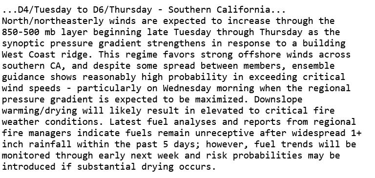
Forecast on track for a potential strong Santa Ana wind event Tuesday-Thursday. The NAM peaks LAX-DAG gradients at -10.1 which is overdone so perhaps in the -8.5 to -9.1 range… which would approach record threshold. The Santa Ana wind event is odd in that a small compact upper level low is going to track south into Mexico which is an atypical path. The upper level low may provide some mountain wave activity potential but it will be filling in so upper support will wane with time. A second larger trough will move into the Great Basin Friday which would reinforce the offshore winds. Details are still too murky at this time on the secondary wind event.

Fire wx condtions could depend on how much drying occurs today through Tuesday as the northerly wind event occurs. The soil is wet and some green up is occurring with a developing grass crop. Fuel receptivity should be pretty limited until humidity falls below 20% for greater than 24 hours time.

Fuels could become receptive by the time the second Santa Ana wind event rolls in.

5 Likes

NWS LA: 1:30pm

For Tuesday night and Wednesday, things are still
looking pretty good for a moderate to strong Santa Ana wind event
for Ventura/LA counties (although it’s not a classic setup).
Models indicate LAX-DAG gradient between -6 and -10 mb. There is
not a lot of cold advection with this setup, but the winds at 950
and 850 mb are forecast to range between 35 and 55 knots. Ensemble
guidance for both the GFS and ECMWF indicate high likelihood of
moderate to strong Santa Ana winds. The ECMWF EFI even has a
"Shift of Tail" of 1 and 2, indicating a high potential for a well
above climatology event. With all this, will issue a HIGH WIND
WATCH for sections of LA and Ventura county (see LAXNPWLOX),
indicating a decent chance of 60+ MPH wind gusts (especially
across the mountains and foothills).

4 Likes

Brush can burn when in full alignment if still dormant even on the heels of firs rain. Unless the dead fuel has enough moisture to slow things down. Let’s see how this goes. Need another good storm to put a cap on things.

3 Likes

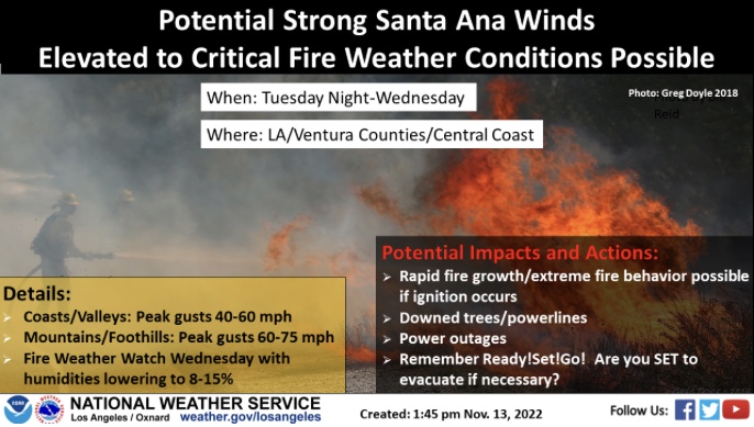
URGENT - FIRE WEATHER MESSAGE
National Weather Service Los Angeles/Oxnard CA
305 PM PST Sun Nov 13 2022

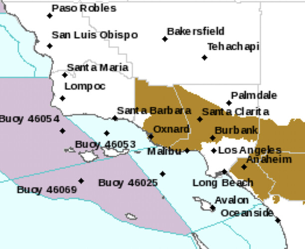
…FIRE WEATHER WATCH IS IN EFFECT FOR WESTERN LOS ANGELES COUNTY
AND MUCH OF VENTURA COUNTY FROM 7 AM TO 7 PM WEDNESDAY…

.Strong high pressure building into the Great Basin may support
the first strong Santa Ana event of the season Tuesday night into
Wednesday. Strong cold air advection will generally limit relative
humidity values above critical values Tuesday night even as
potentially damaging winds develop (see NPWLOX for details on
HIGH WIND WATCH). However, further drying Wednesday morning into
the afternoon and continuing gusty and potentially damaging winds
will potentially support 6 hours or more of critical fire weather
conditions during the watch period.

CAZ253-254-141800-
/O.NEW.KLOX.FW.A.0001.221116T1500Z-221117T0300Z/
Ventura County Mountains-Los Angeles County Mountains-
305 PM PST Sun Nov 13 2022

…FIRE WEATHER WATCH IN EFFECT FROM WEDNESDAY MORNING THROUGH
WEDNESDAY EVENING FOR GUSTY NORTHEAST WINDS AND LOW RELATIVE
HUMIDITY FOR VENTURA COUNTY AND WESTERN LOS ANGELES COUNTY…

The National Weather Service in Los Angeles/Oxnard has issued a
Fire Weather Watch FOR GUSTY NORTHEAST WINDS AND LOW RELATIVE
HUMIDITY, which is in effect from Wednesday morning through
Wednesday evening.

  • Winds…Damaging northeast winds with gusts peaking at 55 to 75
    mph for wind prone mountains. Strongest late Tuesday night
    through Wednesday afternoon.

  • Relative Humidity…Minimum relative humidity of 10 to 20
    percent Wednesday morning and afternoon.

  • Impacts…If fire ignition occurs there could be rapid spread of
    wildfire that would lead to a threat to life and property.

PRECAUTIONARY/PREPAREDNESS ACTIONS…

A Fire Weather Watch means that critical fire weather conditions
are forecast to occur. Listen for later forecasts and possible
Red Flag Warnings.

&&

$$
URGENT - FIRE WEATHER MESSAGE
National Weather Service Los Angeles/Oxnard CA
305 PM PST Sun Nov 13 2022

…FIRE WEATHER WATCH IS IN EFFECT FOR WESTERN LOS ANGELES COUNTY
AND MUCH OF VENTURA COUNTY FROM 7 AM TO 7 PM WEDNESDAY…

.Strong high pressure building into the Great Basin may support
the first strong Santa Ana event of the season Tuesday night into
Wednesday. Strong cold air advection will generally limit relative
humidity values above critical values Tuesday night even as
potentially damaging winds develop (see NPWLOX for details on
HIGH WIND WATCH). However, further drying Wednesday morning into
the afternoon and continuing gusty and potentially damaging winds
will potentially support 6 hours or more of critical fire weather
conditions during the watch period.

CAZ288-354-355-358-359-362-363-547-141800-
/O.NEW.KLOX.FW.A.0001.221116T1500Z-221117T0300Z/
Santa Clarita Valley-Ventura County Beaches-
Ventura County Inland Coast-Central Ventura County Valleys-
Southeastern Ventura County Valleys-Malibu Coast-
Santa Monica Mountains-Los Angeles County San Fernando Valley-
305 PM PST Sun Nov 13 2022

…FIRE WEATHER WATCH IN EFFECT FROM WEDNESDAY MORNING THROUGH
WEDNESDAY EVENING FOR GUSTY NORTHEAST WINDS AND LOW RELATIVE
HUMIDITY FOR MOST OF VENTURA COUNTY AND WESTERN LOS ANGELES
COUNTY…

The National Weather Service in Los Angeles/Oxnard has issued a
Fire Weather Watch FOR GUSTY NORTHEAST WINDS AND LOW RELATIVE
HUMIDITY, which is in effect from Wednesday morning through
Wednesday evening.

  • Winds…Damaging northeast winds with gusts peaking 40 to 60
    mph. Local gusts to 70 mph in the foothills. Strongest early
    Wednesday morning through the afternoon.

  • Relative Humidity…Minimum relative humidity of 8 to 15 percent
    Wednesday late morning and afternoon.

  • Impacts…If fire ignition occurs there could be rapid spread of
    wildfire that would lead to a threat to life and property.

PRECAUTIONARY/PREPAREDNESS ACTIONS…

A Fire Weather Watch means that critical fire weather conditions
are forecast to occur. Listen for later forecasts and possible
Red Flag Warnings.

&&

$$
2 Likes

Looks like a statewide event, with some strong winds for the northern part of the state as well. A potentially damaging Mono Wind event may occur as well. Plenty of snow to reduce or eliminate fire threat, but certainly a notable event.

3 Likes

image

image

1 Like

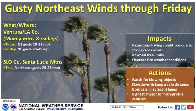
Red flag warning for Western LA County and nearly all of Ventura County, Wednesday 7 am till 7 pm.

4 Likes

Has a Red flag been issued or just anticipated ?