I’ve heard above average wind events.
MVU - Read a couple posts above, I asked them the same question a few days ago. There is never a year with no wind events (I know you know this, you’ve been around a while). Multiple wind events varying in strength are part of the yearly weather pattern. One of the major factors as it affects fire season is with whether the wind events occur before or after wetting rains. DEC/JAN historically host the strongest wind events.
Sorry. I did not look back 5 days ago at your post. My bad. Yes, I have been around for a minute as I am born and raised in SDU….Grossmont Hospital. I have seen the worst in 2003 and 2007 and to a lesser extent our extremely rare major Santa Ana in May of 2014. My point was simply is that we in San Diego county have gone several years without a decent rip and was simply curious if this fall might have a different outcome. Regardless of fire starts……my go to favorite fall mornings is waking up to a warm and dry east wind with unlimited visibility. IMO….the best time of the year. Forgive me for wishing for a little pattern change. We have had fog and marine layer almost every morning this month. It was socked in fog here 8 miles from the coast. That never used to happen growing up. Once June gloom was over its was sun for months. I long for those days when it wasn’t damp every morning in late August….just a lifer in socals opinion. We will see what Mother Nature has in store soon enough 
Definitely agree about Fall months being the best weather for all the things you described. Great for star gazing too!
I will take a shot at answering your question. The two cold fronts that impacted Nops were anomalous but not unheard of. The large ridge in the central part of the US allowed a trough pattern to develop over the PNW. There just happened to be an area of LP lurking out off the coast and was caught up in the flow and tracked over the west coast. Rain in late August is not unheard of for NW Ca but 1/2 inch in the Sacramento Valley is… about a 1/10 return interval for that event.
I do not think it is a signal for any large scale pattern changes or seasonal changes other than what we would expect.
The first offshore wind events for NOPS are driven by troughs and “inside slider” systems passing the state to the north and then HP building back in behind and creating that pressure differential.
Small scale Santa Ana events can occur in similar fashion but those are usually confined to the canyons and inland areas and usually are more notable for their heat and low RH than wind. To get a real deal SA you would want to watch for cold air pooling in the Great Basin. The first really cold snap for that area and a passing trough sets up the pattern change in the Fall where we see cold air pool up and then be pushed across the deserts and into the coastal areas.
I think it is too early to give a specific forecast for below or above average SA events. PDS does a great job at those fall forecasts.
As far as trying to “predict” the future, for now we are the only things that can predict the future and with regard to weather that is only really reliable 3-4 days out. Acorns dropping, leaves turning color and dropping are a reaction to past events( heat, drying, precipitation amount) and are not a specific prediction of the future relative to plant anticipating some large scale change. Animal similarly cannot predict the future, but rather they react to the now( they do not have access to super computers). Every year I hear people talk about deer moving and squirrels being more active.
If you are relying on squirrels to provide you with long range forecasts… I would suggest you review your interactions with them on local roads.
So my take… a little too early to tell what this fall will look like. I would agree… it has been awhile since we have had a large scale region wide run of SA’s.
Oh, you forgot the Scorpions crossing the road😅
Ah yes, in addition to the famed TAL Tarantula activity level haha
Let’s not forget woolly worms
Years ago you could almost predict such things with serious accuracy.
Late Aug, early Sept almost always brought rounds of dry lightning.
Late Sept/early October the Santa Anas were pretty much a sure thing on and off thru Thanksgiving and I remember sending folks south during Christmas several times. Made a few enemies there lol.
All before the term ‘Year round fire season’.  For those who are old enough fire season typically ran from May to the end of Oct except for So Cal and the Santa Ana’s. Nor Cal ended a bit sooner. FF1’s left and we didn’t see them until next season. Times have changed. Weather has changed. Everything has changed lol.
Now? Roll the dice and flip coins.
You are not wrong… the season has changed and strong pattern changes have influenced local changes. Old timers used to say that rain followed a SA event, that is true and it also preempted another SA event. The shoulder seasons of Spring and Fall are when changes occur and we see troughs and ridges ride through our state. Rain would follow a SA because the HP would break down in a progressive pattern, especially later in the year( mid to late October). Early SA’s in September and early October are usually followed by hot weather.
The old timers where I am from used to say that “Tule Fog” came before a North Wind event. That would reason because you would need some cold air and maybe a little moisture for ground fog to form. That would mean cold air had settled into the GB and was available to set up a strong wind event.
That is not always needed… especially for Nops. Most of the large and damaging North Wind events up here have to do with HP building in behind a dry inside slider system.
For lightning… you are correct… September and October favor Central and Socal. This usually comes from decaying tropical remnants that get caught up in HP and advect moisture into the state. The early season Monsoon systems tend to come with more moisture… but there are plenty of occasions with dry lightning in Socal from the Monsoon.
I used to feel that July was the lowest probability for lighting ignitions, but statistically June July August and September are close to even across the board. Early lightning tends to favor Nops and later tends to favor Sops. But that is also anecdotal and there have been plenty of times where that has not been true.
As human’s we look for patterns, for many of us things in series or sequential make us more comfortable. So when the patterns we expect to occur do not… we look for answers. Sometimes it comes down to something as simple as a butterfly flapping its wings somewhere across the world to cause a significant event for us three weeks later…
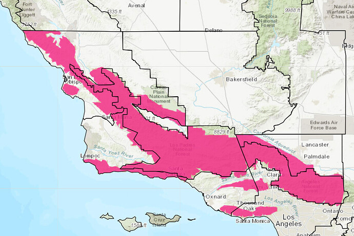
Good evening all, high temperatures should peak tomorrow and Friday. As the ridge breaks down this weekend, stronger onshore flow on top of stressed vegetation and low humidity values could lead to isolated critical fire weather conditions. Additionally, a red flag warning will go into effect tomorrow afternoon through Saturday for the mountains of Southern California due to the potential of plume dominated fire behavior, dry fuels, extreme heat, and low humidity.
https://forecast.weather.gov/wwamap/wwatxtget.php?cwa=SGX&wwa=fire%20weather%20watch
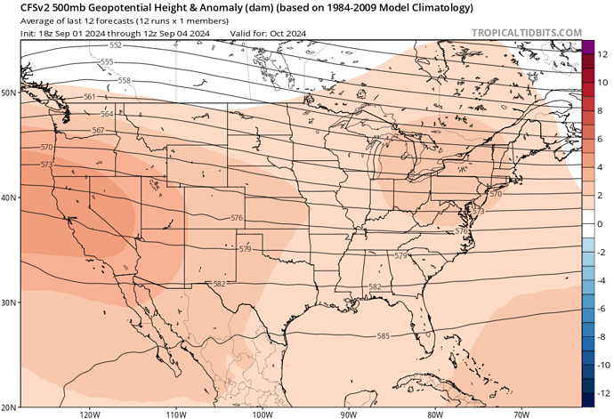
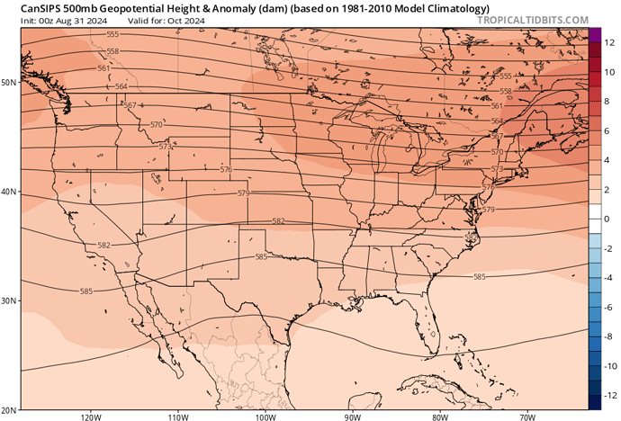
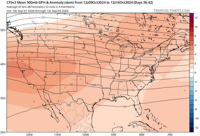
Ensemble clusters and operational models are suggesting a tropical cyclone could form in the eastern pacific next week, with a general movement towards Baja Mexico. I bring this up because when tropical cyclones begin moving furthest north and east in the eastern pacific basin it is the symbolic peak of the summer pattern. The cyclone remnants tend to “carve out” a path that opens the door to inside slider like systems and the winding down of summer. This later peak, in conjunction with off the charts widespread above normal SST anomalies across the Pacific and Atlantic oceans may signal an extended summer pattern possibly into early to the middle of October. Both basins have had large difficulties in transferring the enormous amounts of anomalous ocean heat content to the poles in the form of tropical cyclones. It is very unusual for both basins to be so quiet at the same time. The mechanism of tropical cyclones moving poleward, destabilizes cooler airmasses at the poles leading to these airmasses eventually heading south and putting us into a fall pattern. So with both basins quiet for now and SST/ocean heat content off the charts the summer pattern could last into October at least in a quasi form. CFS weekly, CFS monthly, and climate prediction center data support this philosophy.
Temps of 107 and 117 will become common over
the valleys, lower mountains and deserts. Inland coastal plains
will see peak highs between 93 and 103, including the Santa Barbara
foothills. Sundowner winds will increase over southern Santa Barbara County, peaking tonight and Friday night with gusts between 25 and 40 mph common over most of the Santa Ynez Range. Otherwise, stronger than usual diurnal winds are expected, with west to northwest gusts between 15 and 30 mph common over most areas each afternoon and evening, and some local north to northeast gusts of 15 to 25 mph each night. With high mixing heights up to 18,000 feet, there is also high potential for erratic plume-dominated fire behavior especially in the mountains. The chance for Red Flag conditions and durations has increased to 80 percent over the areas of most concern, including southern Santa Barbara County, the Santa Monica Mountains, and the Santa Susana Mountains. For the rest of the mountains and foothills, while winds will limit the potential for classic red flag criteria, there is a history of large fires with similar weather conditions during this time of the year, especially considering the plume dominated fire potential. So a Red Flag Warning will be in effect to handle this threat
EGP is showing strikes on the back side of Big Bear, San Jacinto, Palomar and Wrightwood


