20 inches, that’s crazy…Get your gold pans out.
6 Likes
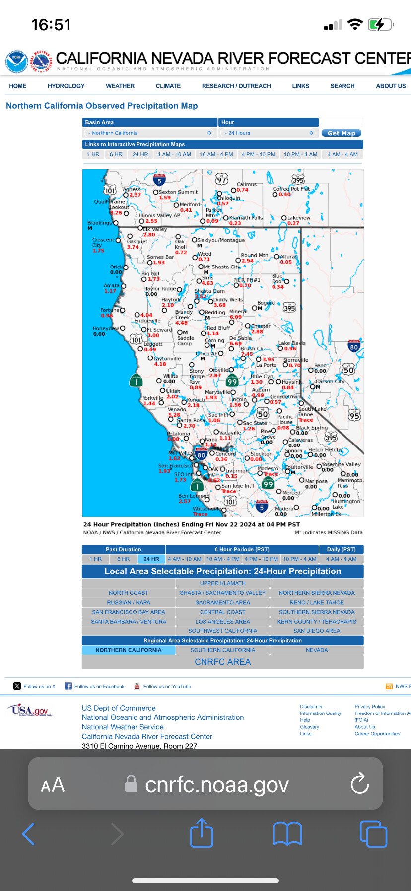
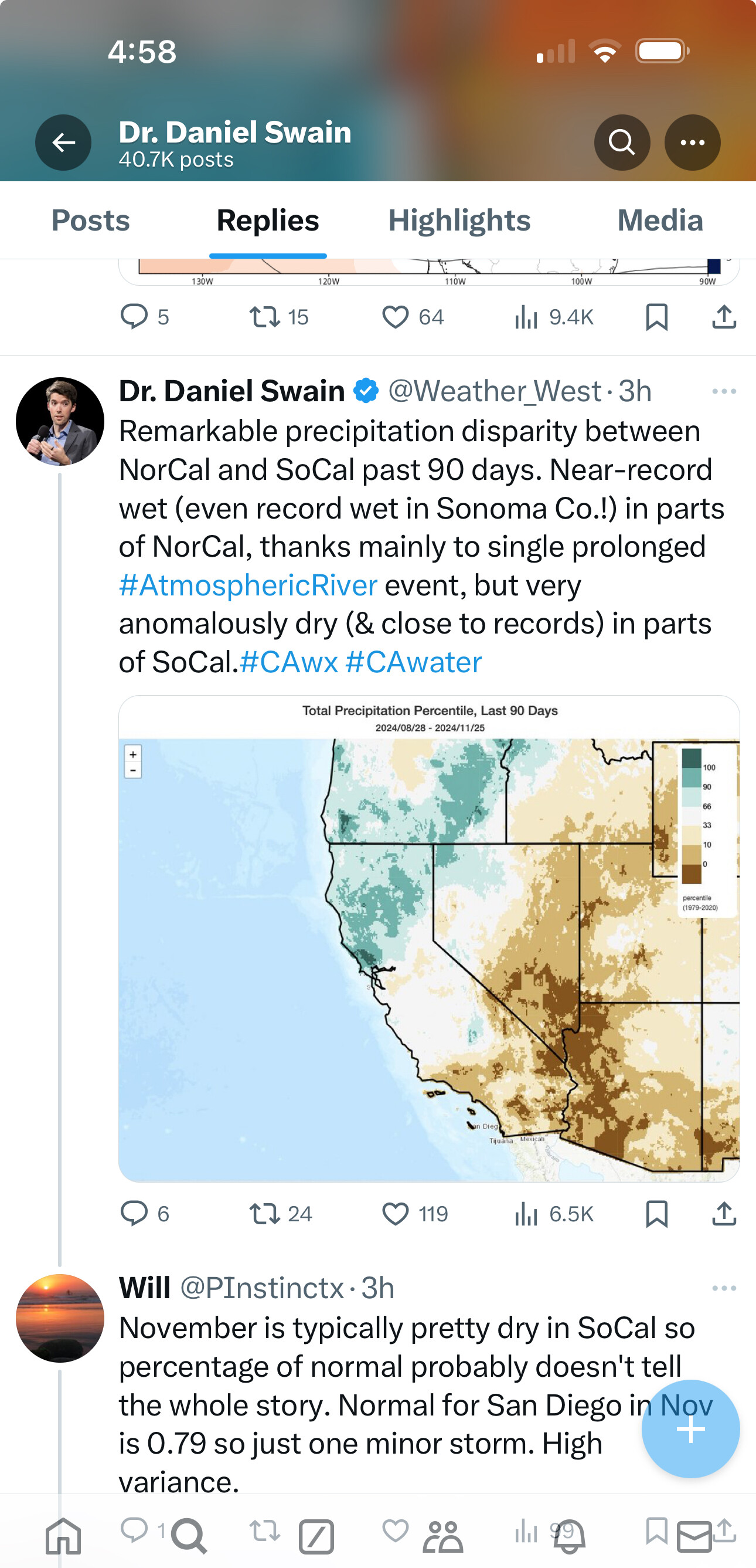
Sonoma isn’t Southern California. Sonora is…barely.
4 Likes
Well, looking at the radar it looks like a fairly dry Saturday ahead for Fresno after some rain this morning.
5 Likes
For Southern California, with the frontal boundary washing out and bringing very little precipitation so far the potential will exist for receptive fuels overlapping the climatological peak of Santa Ana wind season which is now into December. The last event changed into ridging over us with the bomb cyclone into the North West.
8 Likes
well, at least I’m not seeing any significant offshore wind events in the models for at least 7 days.
2 Likes
And we are seeing that today.
2 Likes
3 Likes
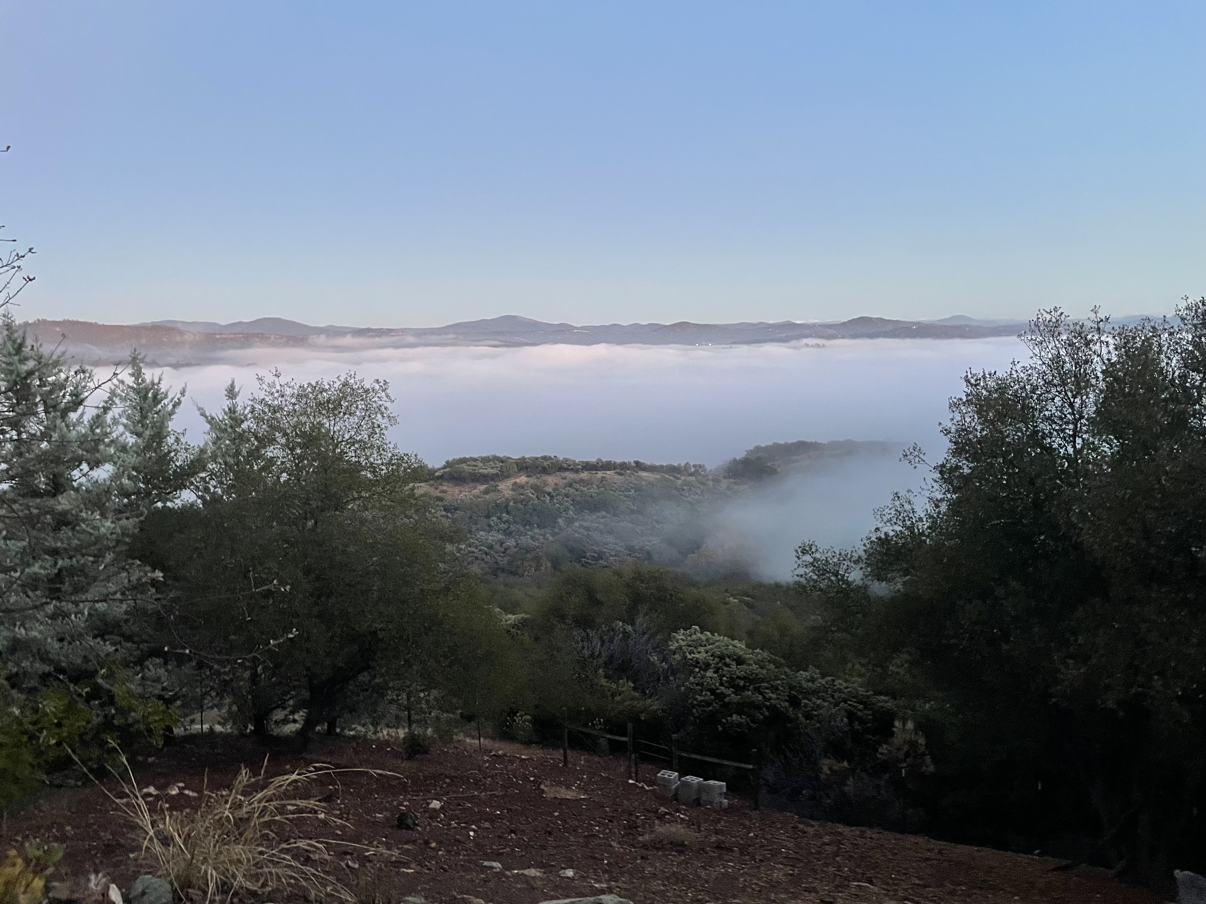
Fog rolled in over Sonora this evening. 47 out, calm winds and RH off the chart. That fog brings back a lot of memories running calls in Mid Valley.
7 Likes
3 Likes
6 Likes
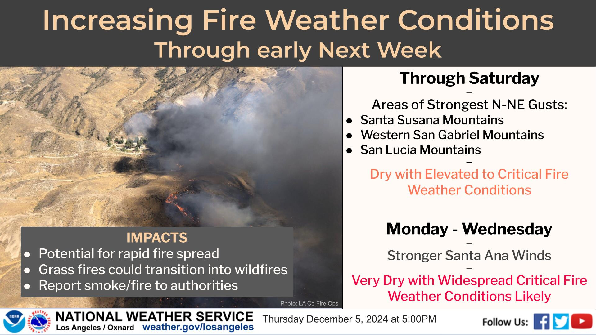
From LOX: Tuesday remains the day to watch as a moderate to strong Santa Ana
wind event is in the offing. The offshore push to the west will
be close to 7 mb. Almost as important is the speed at which the
offshore flow develops with some mdls showing a 8 mb change in
the gradient in just 24 hours. Wind Advisories are almost a
certainty and a few High Wind Warnings look probable with winds 35
mph to 50 mph or more. This event will be very dry, with relative
humidity dropping into the 5-15% range leading to fire weather
issues. The interior will continue to cool on Tuesday but unlike
on Monday, the offshore push will be strong enough to bring a
warming trend to the csts/vlys.
7 Likes
One product issued by NWS for: Alpine CA
Fire Weather Watch
URGENT - FIRE WEATHER MESSAGE
National Weather Service San Diego CA
124 PM PST Fri Dec 6 2024
…FIRE WEATHER WATCH IS IN EFFECT FROM MONDAY MORNING UNTIL
TUESDAY NIGHT FOR STRONG GUSTY SANTA ANA WINDS AND LOW RELATIVE
HUMIDITY FOR ALL MOUNTAIN AREAS, THE INLAND EMPIRE, AND THE SAN
DIEGO COUNTY PORTIONS OF THE SAN DIEGO VALLEYS…
CAZ248-250-255>258-265-070530-
/O.NEW.KSGX.FW.A.0005.241209T1800Z-241211T1200Z/
San Bernardino and Riverside County Valleys - The Inland Empire-
San Diego County Inland Valleys-San Bernardino County Mountains-
Including The Mountain Top And Front Country Ranger Districts Of
The San Bernardino National Forest-Riverside County Mountains-
Including The San Jacinto Ranger District Of The San Bernardino
National Forest-Santa Ana Mountains-
Including The Trabuco Ranger District of the Cleveland National
Forest-San Diego County Mountains-
Including The Palomar And Descanso Ranger Districts of the
Cleveland National Forest-San Gorgonio Pass Near Banning-
124 PM PST Fri Dec 6 2024
…FIRE WEATHER WATCH IS IN EFFECT FROM MONDAY MORNING UNTIL
TUESDAY NIGHT FOR STRONG GUSTY SANTA ANA WINDS AND LOW RELATIVE
HUMIDITY FOR ALL MOUNTAIN AREAS, THE INLAND EMPIRE, AND THE SAN
DIEGO COUNTY PORTIONS OF THE SAN DIEGO VALLEYS…
-
WINDS…Northeast and east winds 20 to 30 mph. Gusts in the
valleys 25 to 40 mph, locally up to 60 mph in mountains and
passes. Highest winds in the San Gorgonio Pass and San Diego
County mountains and foothills. -
RELATIVE HUMIDITY…5 to 10 percent.
-
IMPACTS…Any fires that develop will likely spread rapidly.
Outdoor burning is not recommended. Outdoor property may be
damaged along with difficult driving conditions. -
LOCATION…San Bernardino and Riverside County Valleys -The
Inland Empire, San Diego County Inland Valleys, San Bernardino
County Mountains-Including The Mountain Top And Front Country
Ranger Districts Of The San Bernardino National Forest,
Riverside County Mountains-Including The San Jacinto Ranger
District Of The San Bernardino National Forest, Santa Ana
Mountains-Including The Trabuco Ranger District of the
Cleveland National Forest, San Diego County Mountains-
Including The Palomar And Descanso Ranger Districts of the
Cleveland National Forest and San Gorgonio Pass Near Banning.
PRECAUTIONARY/PREPAREDNESS ACTIONS…
A Fire Weather Watch means that critical fire weather conditions
are forecast to occur. Listen for later forecasts and possible
Red Flag Warnings.
7 Likes

4 Likes
ne product issued by NWS for: Alpine CA
Red Flag Warning
URGENT - FIRE WEATHER MESSAGE
National Weather Service San Diego CA
935 PM PST Sat Dec 7 2024
…RED FLAG WARNING IN EFFECT FROM 10 AM MONDAY TO 4 AM PST
WEDNESDAY FOR STRONG GUSTY SANTA ANA WINDS AND LOW RELATIVE
HUMIDITY IN ALL MOUNTAIN AREAS, THE INLAND EMPIRE, AND SAN DIEGO
COUNTY VALLEYS…
CAZ248-250-255>258-265-081400-
/O.CON.KSGX.FW.W.0005.241209T1800Z-241211T1200Z/
San Bernardino and Riverside County Valleys - The Inland Empire-
San Diego County Inland Valleys-San Bernardino County Mountains-
Including The Mountain Top And Front Country Ranger Districts Of
The San Bernardino National Forest-Riverside County Mountains-
Including The San Jacinto Ranger District Of The San Bernardino
National Forest-Santa Ana Mountains-
Including The Trabuco Ranger District of the Cleveland National
Forest-San Diego County Mountains-
Including The Palomar And Descanso Ranger Districts of the
Cleveland National Forest-San Gorgonio Pass Near Banning-
935 PM PST Sat Dec 7 2024
…RED FLAG WARNING REMAINS IN EFFECT FROM 10 AM MONDAY TO 4 AM
PST WEDNESDAY FOR STRONG GUSTY SANTA ANA WINDS AND LOW RELATIVE
HUMIDITY IN ALL MOUNTAIN AREAS, THE INLAND EMPIRE, AND SAN DIEGO
COUNTY VALLEYS…
-
WINDS…Northeast and east winds 20 to 30 mph. Gusts in the
valleys 35 to 45 mph, locally over 60 mph in mountains and
passes. Highest winds in east-west oriented passes, such as
the San Gorgonio Pass and San Diego County mountains and
foothills. -
RELATIVE HUMIDITY…As low as 5 to 10 percent. Though winds
will be calmer by Wednesday and Thursday, relative humidity
will stay in this range each afternoon. -
IMPACTS…Any fires that develop will likely spread rapidly.
Outdoor burning is not recommended. Outdoor property may be
damaged along with difficult driving conditions. -
LOCATION…San Bernardino and Riverside County Valleys -The
Inland Empire, San Diego County Inland Valleys, San Bernardino
County Mountains-Including The Mountain Top And Front Country
Ranger Districts Of The San Bernardino National Forest,
Riverside County Mountains-Including The San Jacinto Ranger
District Of The San Bernardino National Forest, Santa Ana
Mountains-Including The Trabuco Ranger District of the
Cleveland National Forest, San Diego County Mountains-
Including The Palomar And Descanso Ranger Districts of the
Cleveland National Forest and San Gorgonio Pass Near Banning.
PRECAUTIONARY/PREPAREDNESS ACTIONS…
A Red Flag Warning means that critical fire weather conditions
are either occurring now…or will shortly. A combination of
strong winds…low relative humidity…and warm temperatures can
contribute to extreme fire behavior.
6 Likes
2 Likes
Not sure if everyone has hung up their boots for the winter or are a little apprehensive to post after the total bust of the previous Santa Ana that never happened. Its weather guys and girls…nothing to be ashamed of for missing a forecast…it happens.
LA NWS has issued a rare PDS RFW for tomorrow…
URGENT - FIRE WEATHER MESSAGE
National Weather Service Los Angeles/Oxnard CA
404 PM PST Sun Dec 8 2024
…PARTICULARLY DANGEROUS SITUATION (PDS) RED FLAG WARNING IN
EFFECT FROM 10 PM MONDAY UNTIL 2 PM TUESDAY DUE TO DAMAGING SANTA
ANA WINDS AND VERY LOW HUMIDITIES FOR THE FOLLOWING AREAS: SAN
GABRIEL MOUNTAINS/ SANTA MONICA MOUNTAINS/ SANTA CLARITA VALLEY/
VENTURA COUNTY COASTS AND VALLEYS/ WESTERN SAN FERNANDO VALLEY –
AND RED FLAG WARNINGS IN EFFECT FOR ALL OTHER TIMES FROM 10 AM
MONDAY UNTIL 6 PM WEDNESDAY IN THESE SAME AREAS…
NWS in San Diego does not use this category yet (I beleive) as this is not a standard alert used by all NWS offices. They are however, predicting conditions not seen since 2003 and 2007. Winds in Ramona are forecast to be in the 50’s most of tomorrow and RH in the 3-8% range. It is still extremely dry and crispy in most of SDU as we have really had almost zero rain except in spots.
Everyone please stay safe as we all saw what happened 3 weeks ago on the Mountain Fire. Something similar is very likely given the current forecast.
4 Likes
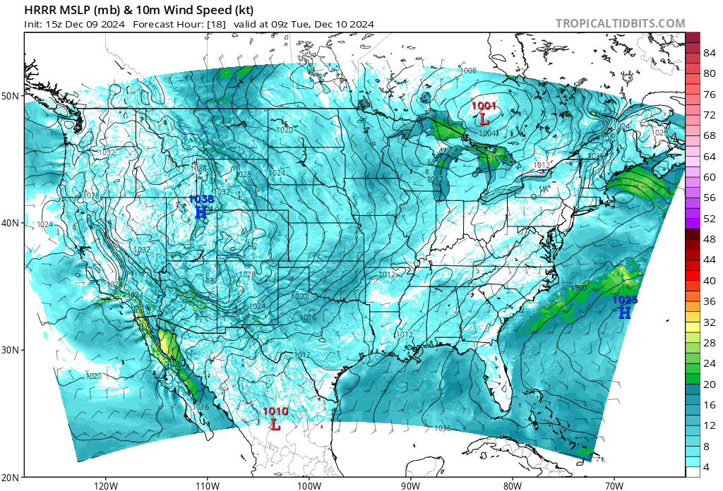
After the small system brushed by the state and tracked into the lower GB the HP is building in and with the cold air pool in place this will produce an efficient offshore flow. From the hi-res model the peak of the offshore winds looks to be tonight. The HRR points to a widespread event with two critical areas. The mountains of LA County and Ventura and the Inland Empire east of Orange and south into San Diego. The winds there could be above advisory levels and cause some general damage.
Beyond this event as is true with many late season SA’s, some precip could make it to SOPS by Thursday night into Friday. NOPS does look to finally get some rain and snow beginning on Wednesday evening and lasting through the weekend.
6 Likes