O.o Interesting way to describe a heat wave. I also find it interesting to hear Mets describe environents for plume domination in Southern California. I dont fully disagree, but i think these events are far fewer in numbers then they adverstise is a brush component. Station fire is proably one of the rare exceptions.
Plume development on a fire has much more to do with atmosphere than fuel bed. I have seen short term PC development on burns done on the valley floor in riparian areas. The strength of the high pressure and depth of the warm air are what is causing this situation. This summer our heat has mostly remained at shallow elevations, meaning that you did not need to ascend very high before you hit cooler air. This has allowed the thermal belts to remain rather cool this year. This has caused the fuels to dry much slower and recover much better.
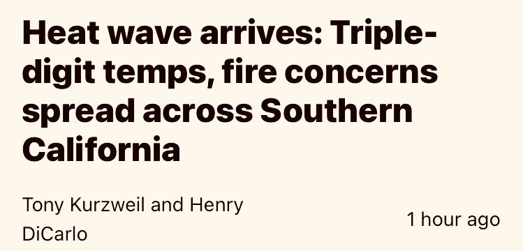
This event looks to have several things supporting the potential for a plume dominated fire. Warm to very warm temperatures.. according to the NWS… the warmest of the year. Monsoonal moisture intrusion with high preciptatble water(PW) associated. Yesterday is was at 1.25-1.5 inches. That is very high and will be noticeable in the form of humidity. The third is moderate winds moving up the slopes due to the warm air and cool ocean temps. Land heats up much faster than water so that drives the daily “diurnal” wind flow pattern.
All of these conditions will influence a fire to potentially become plume dominated.
The fuel bed is a component but is more of an influence when it comes to continuity than amount. As the fuel is consumed it releases moisture which is lofted in the column and releases heat as it rises. In a dry stable atmosphere the column growth is limited as the moisture(energy) is limited at it rises. When we see increased mixing heights, higher PWAT’s and greater depth of heat.. we see the chances increase for rapid column development.
One last note on plume influenced fires… while I do think that a column can collapse.. it is a rare event and requires a very specific set of circumstances to exist.
If “Column Collapse” was as common as it is called out.. I suspect there would be a 19th situation that shouts watch out and specific metrics to measure and predict the event. I also think there would be dozens of incidents a year where close calls happened due to the event.
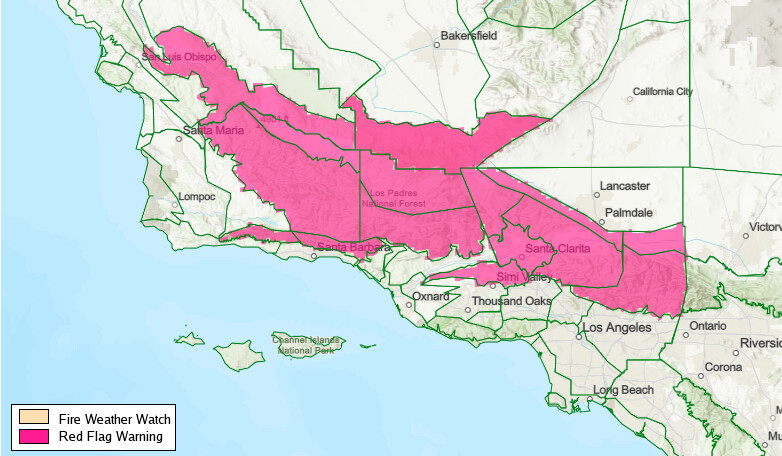
From Moutainsandforests: “The NWS compares this event to the burn conditions that were present during the 2009 Station, 2020 Bobcat, and 2024 Bridge fires,” were plume dominated fires.
Thanks for spending the time to speak on some of the principals of plume developmemt.
My previous comment was directed to the actual action of plume “domination”. When the power of fire becomes stronger than the power of weather or other primary drivers of fire direction and intensity.
I suppose this is somewhat similar to people talking about fires “capping out” as if it is a stand alone measure of intensity of a fire. When in fact you can have a fire “cap out” when when its a small RX as you described.
In some cases this is probably splitting hairs, but it to me is a significant when the fire itself drives the environent and i dont see it as much in southern California but found it more common in timber or timber/brush componet fuel beds where the amount of BTUs pushed by the fire has a much higher odds of changing the environent as a whole.
Hope my prespective makes sense. These dialogs are so much easier in person than typed.
It does.. and you are correct.. not a common phenomenon in much of SoCal. There was a time when some units and forests called out the Haines index each day.
As you know there are many things that can effect how a plume grows and behaves.. the principle being wind, with atmosphere falling close behind. Intense runs through drainages and deep fuel beds can drive a short term plume and then it will calm down.
XBO type 3 OES Prepo in San Bernardino County since yesterday
Feel free to ignore this..
I know it’s fantasy land this far out & there is allot happening in the near term/currently BUT what if??
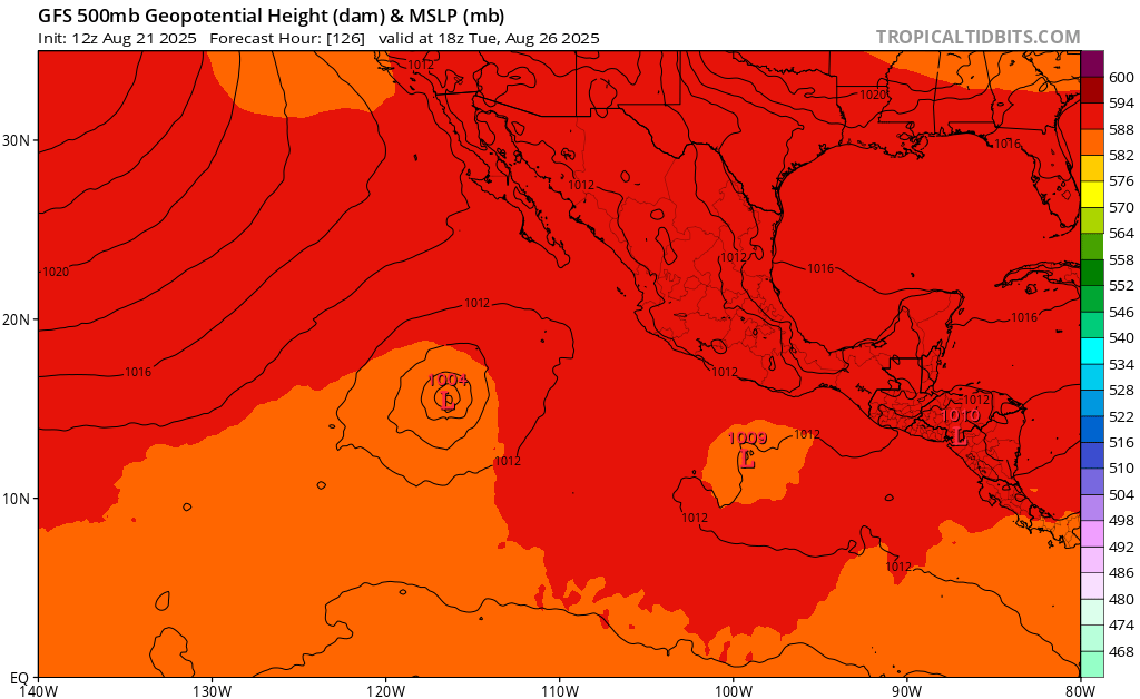
I was waiting to bring this up until we got better ensemble member cluster support, I would not be shocked if it happens. The monsoon is being compressed into a single event essentially. The Canadian model which is tied to the Euro is the most aggressive.
I think based on satellite imagery, an area of low pressure (the eastern one) is developing faster than the models think.
What does this break down to in easy speak?
Thank you. These guys make me feel soooo dumb, cause I am. They just remind me of it. Lol
It means the models are hinting at a tropical cyclone, developing off the coast of Baja and moving north. Potenrially bringing us some rain or more. But because an area of low pressure has not developed yet the models are inconsistent with track etc
It means there is likely to be a hurricane…or two. Maybe even dancing around each other.
God only knows what that will do to SOPS & maybe even NOPS or the SW fire weather. Could be a gully washer or could mean ![]()
![]()