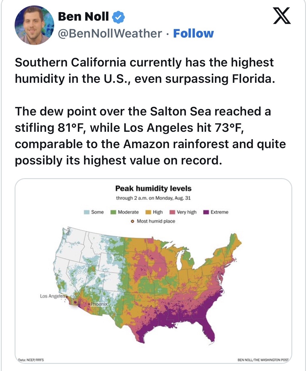
Well that’s not good news
We got just under a 10th of an inch of rain in the auberry area and the best news is no lightning.
This morning‘s model runs have shifted Marie to the right. Moreover, based on the visible satellite imagery this morning of future Marie there is already an established low level center suggesting the storm is already organized far ahead of the GFS modeling. This also has slight track implications. Because Marie will be entering a perfect environment and a further track to the right it is likely to intensify into a major hurricane. This would lead the storm to take a northerly track as it will be taller and able to phase with the upper level trough. Due to the AI models bias in over amplifying and smoothing out the ridge in the mid term those models should be discounted for now. We will explore if it will actually be a threat to us in the next couple days.
SoOpsPredServ~Assessment_Outlook~Sept-Dec26~30aug26.pdf (2.2 MB)
September – December 2026 South Ops Highlights
• Precipitation will likely be near to below normal in September and then above normal in October
through December.
• Temperatures will likely be above normal in September and then below normal October through
December.
• There will likely be a below normal amount of Santa Ana wind events October through December.
Is any of the precip that is currently heavy in Arizona expected to drift towards SoCal?
For those of you wondering for the potential of tropical moisture next week, Michael Snyder gives a good picture on what could happen next well.
NWS SD:
We are monitoring an area of low pressure and thunderstorms located well off the southern coast of Mexico, currently identified by the National Hurricane Center as Invest 95-E. As it stands now, there is a 90% chance that it will develop into a tropical cyclone in the next 48 hours. However, the current forecast track for this potential storm shows a large spread, leading to very high uncertainty. Attached is a graphic showing this spread of all forecast models, featuring 2 main clusters of tracks. At this time, the westward track is the more favored track which would take the storm out to sea. The northward track is less likely. Long-range forecasts inherently carry significant uncertainty, particularly with a system that has not yet developed. A few single deterministic models show a northerly solution, but they are extreme outliers amongst the guidance suite that the National Hurricane Center uses.
Potential impacts from 95E at this time include the risk for coastal flooding as astronomical high tides will occur the week of Labor Day. Associated tropical swells are roughly forecast to arrive Saturday/Sunday, coinciding with high tides of 6.2–6.5 ft. Anticipated wave heights will depend on the track of the storm, so these remain uncertain. It is still way too early to discuss expected rainfall totals, however even with a storm track further out to sea, tropical moisture may still be funneled into the area during Labor Day Weekend.
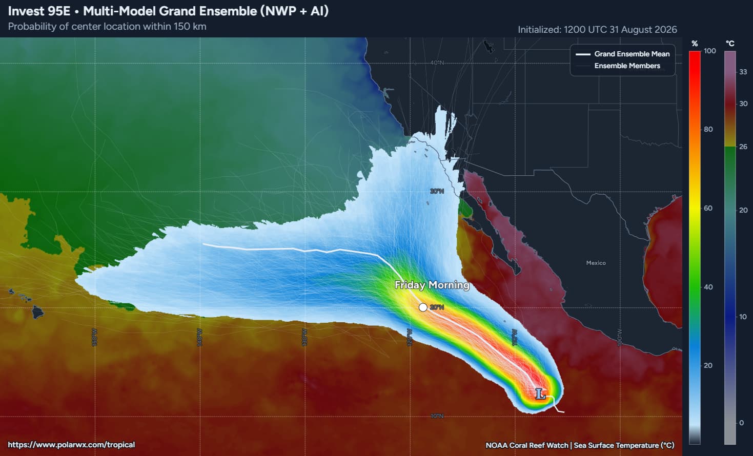
Model tracks from tropical tidbits:
95E_eps_latest.png (800×800)
95E_tracks_latest.png (768×801)
National weather service Los Angeles in their discussion this evening talks about the possible scenarios for this weekends weather. Which go from possible tropical rain to hot dry Santa Ana winds with elevated fire danger. Only happens in So Cal.
Forecasting California weather is easy—until the Pacific becomes involved.
Marie has trended larger in diameter on the hurricane models, and it will have the same structure and size as Hilary. It takes large storms a long time to deepen and increase maximum wind speeds. I am of the opinion that if the storm is able to develop an inner core and deepen below 955 MB the storm will take a northerly track… not necessarily towards landfall but off the coast of California. Have maintained that I think superheated down sloping Santa Ana winds are a concern if a storm manages to make it off the coastline.
So really it comes down to how much the storm can deepen, because most of the model runs you see the storm moving to the left miss the upper level trough by a razor thin margin. There should be a period of about 72 to 96 hours where the only barrier to intensification is the storm structure itself…
Will add that if the storm happens to end up recurving, there is a loop eddy with 28° to 30° C water pushing towards the west towards 120° W x 27° N over the next 3-5 days, which is simply unbelievable.
Morning addendum: the storm rapidly organized overnight and is approaching hurricane strength based on DVORAK estimates (988 MB). The center was dragged NE under heavy thunderstorms. All model runs this morning are off because of the rapid organization.
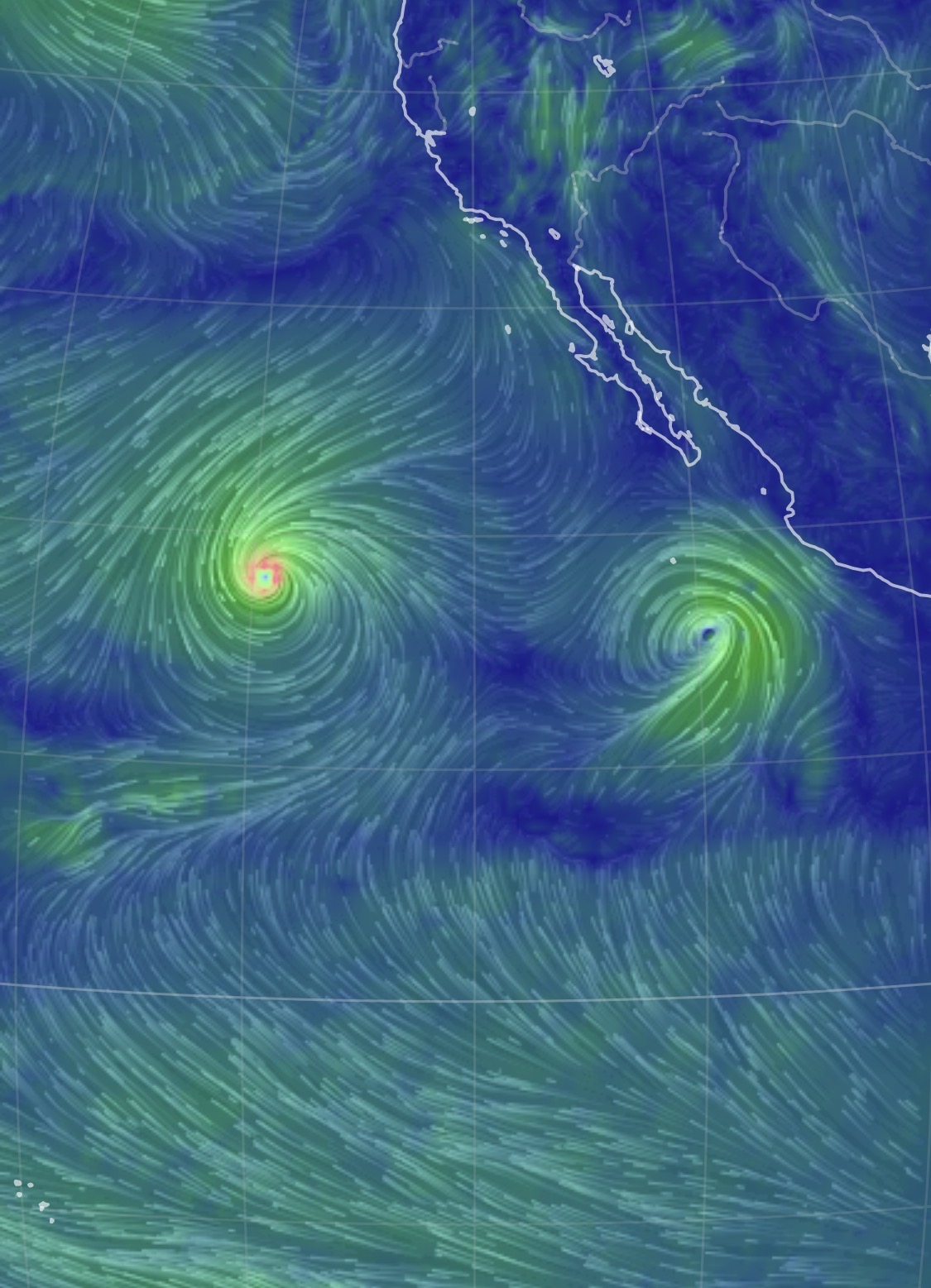


No, the storms are too far apart. The biggest influence will be if the storm deepens enough in the short term. This will keep the storm on the right side of the forecast track and the water temperatures are much warmer on the right side of the track around 29 to 30°, so the added heat will also cause the storm to move to the right should it choose that path by proxy of the potential for further strengthening. The one marker to watch out for is where it moves relative to Socorro Island.
SDG&E is calling and sending texts testing their emergency notification system. Haven’t seen that in a few years so has me thinking they are either doing belts & suspenders or worried about a potential something. Wouldn’t surprise me if the drones and helos fly the power lines in the next couple of days.
It seems very unlikely at this point that the storm is going to get here, but I was just outlining the scenario that would make it happen. The interesting thing is that the forecasted track of Marie would likely force the coastal trapped kelvin wave all the way into Southern California, so we could run it back again with another storm but with the 26 degree isotherm all the way up here.
So assuming marie does not come this way… what would we be looking at in terms of weather ? Just humidity and more heat ?
Groundhog Day again!!! More garbage weather and if the coastal trapped kelvin wave gets pushed up the coast and couples with a high pressure system it could be even worse than before the next few weeks
In a word ugh. Last 2 nights the marine layer pushed temps down to the low 60’s which has been really nice. Before that mostly 80-ish which is in no way comfortable.
We will likely start discussing the storm behind Marie in the next couple days because I think it’s more likely to affect us. The 26 degree isotherm will have been dragged so far NW by Marie, and the AI models have been adamant about a recurving storm… which they never actually showed for Marie.
Marie has a giant circulation and is going to move a crazy amount of warm water further NW. Discussing really because there isn’t anything else to discuss this season.