No I don’t think they are at fairground this time, they are at Masonite industrial road, I’m pretty sure. Someone asked where camp was set up.
Factory Pipe
Are there any webcams in the area of these fires ?
Im looking for a good OPS map of the complex…and perhaps some info on where i can get this info myself. Thanks.
https://m.box.com/shared_item/https%3A%2F%2Fcalfire.app.box.com%2Fv%2Fcalfireimt2/browse/51765482451
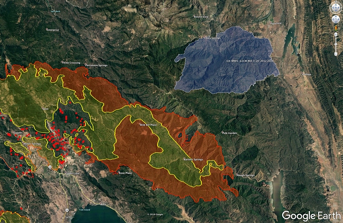
The Mill Fire (2012) was the last large fire in the area NE of the Ranch Fire. Here is a map - Mill Fire in Blue.
Word is the River and the Ranch burned together today and it will now just be the Ranch Fire. See what tomorrow’s IAP and maps say.
Multiple sources saying this isn’t true, including a CalFire PIO on Twitter, stating that this isn’t true. Waiting on verification. Let’s wait and see what’s confirmed.
Not saying it’s untrue, but just waiting on the official word
Live ranch fire feed
not true. i’m on the river fire. the river fire got a great firing operation last night. should be close to done. the ranch is going strong still.
Significant ash fall overnight, all over cars and everything. Here in Nevada County.
Ranch:
156,678 acres - 27% contained
River:
44,793 acres - 50% contained
Updated at 0650
I was watering the plants this am and was watching it fall in the sun. Always amazes me how far it can travel. Our local government strike team is on the line today on the Ranch. Fingers crossed the beast behaves today.
Anyone have a link for cdf cmnd 8?
Hearing possible evacuations for stonyford can anybody confirm that.
Does anyone know the locations of the Base Camps? Are there 2 or just one?


