CA-BTU-Dixie(contained)

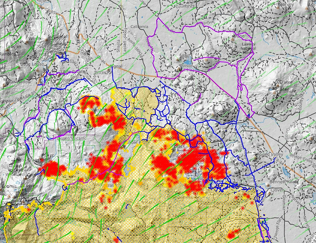
Old Station area.
Dark blue = tagged as various types of completed lines.
Purple = tagged as planned lines.

Can’t post three times in a row, so editing this one with new KML files…

KML files filtered from 083121 data package found here:
https://ftp.wildfire.gov/public/incident_specific_data/calif_n/!CALFIRE/!2021_Incidents/CA-BTU-009205_Dixie/GIS/IncidentData/20210831/

For import into CalTopo, Google Earth, etc. Can’t vouch for how accurate they keep the data vs what’s really on the ground.

Completed Dozer Line:

Completed All Types Of Line

Planned Dozer and Hand Line:

2 Likes

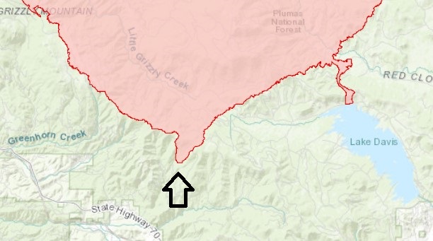
Looks to be a slop-over on Grizzly ridge according the the perimeter map on Inciweb but I have not been able to get any intel from the Dixie people yet…

GRIZZLY SLOP

2 Likes

So in last nights briefing they stated that there was no slop-over and that this was an anomaly during the IR flight…

2 Likes

KML files filtered from 20210901 data package found here:
https://ftp.wildfire.gov/public/incident_specific_data/calif_n/!CALFIRE/!2021_Incidents/CA-BTU-009205_Dixie/GIS/IncidentData/20210901/

For import into CalTopo, Google Earth, etc. Can’t vouch for how accurate they keep the data vs what’s really on the ground.

Completed Dozer Line:

Completed All Type Of Line:

Planned Dozer And Hand Line:

Dozer line running south of black mountain…well that didn’t work. Up next 395.

http://www.alertwildfire.org/shastamodoc/index.html?camera=Axis-ShafferMtn&v=fd40730

2 Likes

You can see the entire susanville / honey lake basin in near real time, scroll down to the antelope 24 camera and then scroll right…

https://weathernode.net/flir-panoramas/all

3 Likes

KML files filtered from 20210902 data package found here:
https://ftp.wildfire.gov/public/incident_specific_data/calif_n/!CALFIRE/!2021_Incidents/CA-BTU-009205_Dixie/GIS/IncidentData/20210902/

For import into CalTopo, Google Earth, etc. Can’t vouch for how accurate they keep the data vs what’s really on the ground.

Completed Dozer Line:

Completed All Type Of Line:

Planned Dozer And Hand Line:

2 Likes

9/02 morning IR Dixie Fire. 12 hours old…

KML files filtered from 20210903 data package found here:
https://ftp.wildfire.gov/public/incident_specific_data/calif_n/!CALFIRE/!2021_Incidents/CA-BTU-009205_Dixie/GIS/IncidentData/20210903/

For import into CalTopo, Google Earth, etc. Can’t vouch for how accurate they keep the data vs what’s really on the ground.

Completed Dozer Line:

Completed All Type Of Line:

Planned All Type Of Line (note this adds two types (Mixed Construction and Fuel Break) compared to my previous posts :

5 scoopers working near herlong junction.

7 Likes

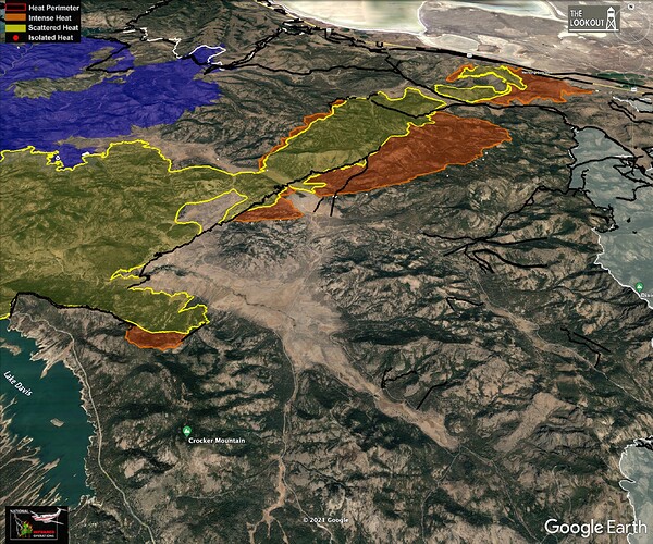
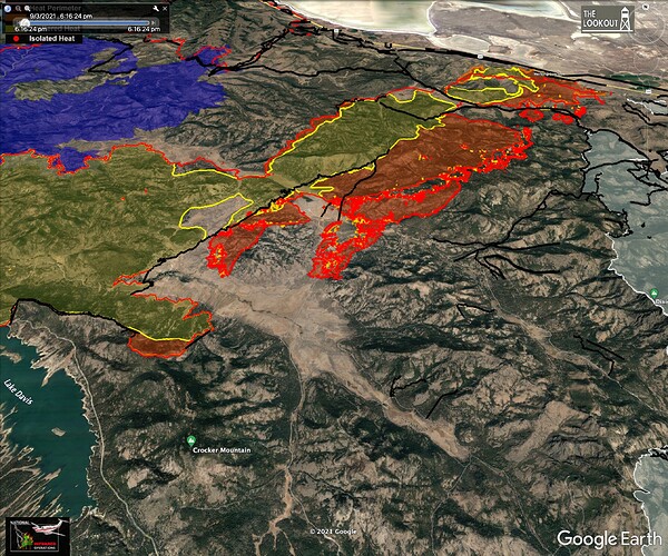
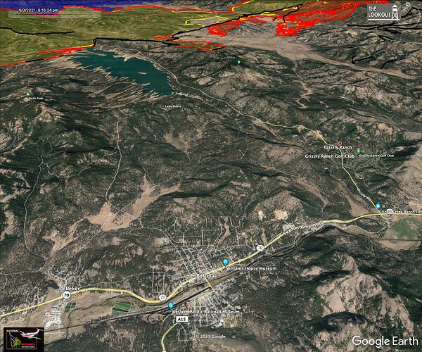
Dixie decided to head back west this afternoon.
Here are two shots. One shows last night’s perimeter, second shows IR from 6:45 pm today. Third shows relation to Portola.

6 Likes

Fire looks to be active tonight and is visible on the Beckworth Peak and North Portola cams. GOES also showing quite a bit of heat.

KML files filtered from 20210904 data package found here:
https://ftp.wildfire.gov/public/incident_specific_data/calif_n/!CALFIRE/!2021_Incidents/CA-BTU-009205_Dixie/GIS/IncidentData/20210904/

For import into CalTopo, Google Earth, etc. Can’t vouch for how accurate they keep the data vs what’s really on the ground.

Completed Dozer Line. There are 3511 entries vs 3418 yesterday:

Completed All Type Of Line. There are 4579 entries vs 4461 yesterday:

Planned All Type Of Line. There are 154 entries vs 155 yesterday:

Dixie AA requesting 3 VLATS to Div PP

5 Likes

Sad news from the Dixie, RIP.

Morning update with maps (thanks @tumbleweed) on The Lookout.
Also a Youtube video (some problems with missing audio…) about fuels management and the Dixie and Caldor Fires. Dixie Fire – 9/5/2021 Morning Update – The Lookout

5 Likes

KML files filtered from 20210905 data package found here:
https://ftp.wildfire.gov/public/incident_specific_data/calif_n/!CALFIRE/!2021_Incidents/CA-BTU-009205_Dixie/GIS/IncidentData/20210905/

For import into CalTopo, Google Earth, etc. Can’t vouch for how accurate they keep the data vs what’s really on the ground.

Completed Dozer Line. There are 3577 entries vs 3511 yesterday:

Completed All Type Of Line. There are 4667 entries vs 4579 yesterday:

Planned All Type Of Line. There are 151 entries vs 154 yesterday:

3 Likes

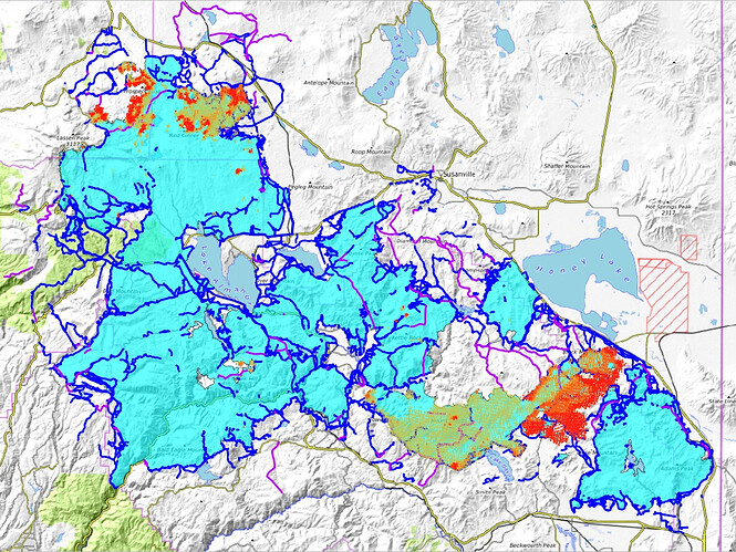
Latest VIIRS along with some of today’s data package:
Red dots = Detection last 24 hours.
Dark Orange dots = Detection Last 48 hours.
Light Orange dots = Detection Last 72 hours.
Cyan = Fire Perimeter. Note that the Beckwourth Complex is included at lower right.
Dark Blue lines = Completed All Types Of Line.
Purple lines = Planned All Types Of Line.

OK Can’t post three in a row, so here’s my 2nd post in a row edited with new KML files…

KML files filtered from 20210906 data package found here:
https://ftp.wildfire.gov/public/incident_specific_data/calif_n/!CALFIRE/!2021_Incidents/CA-BTU-009205_Dixie/GIS/IncidentData/20210906/

For import into CalTopo, Google Earth, etc. Can’t vouch for how accurate they keep the data vs what’s really on the ground.

Completed Dozer Line. There are 3650 entries vs 3577 yesterday:

Completed All Type Of Line. There are 4775 entries vs 4667 yesterday:

Planned All Type Of Line. There are 152 entries vs 151 yesterday:

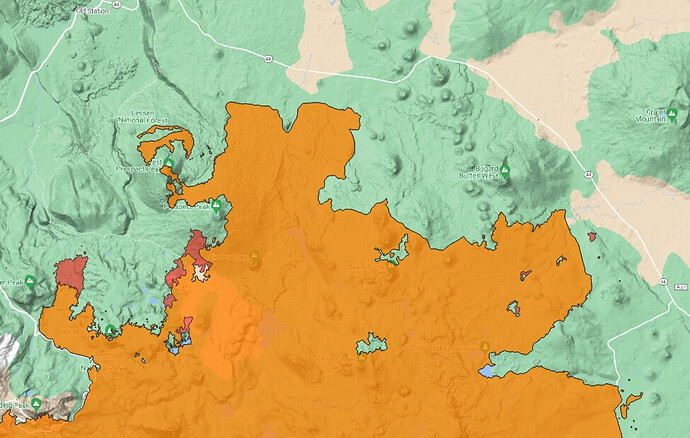
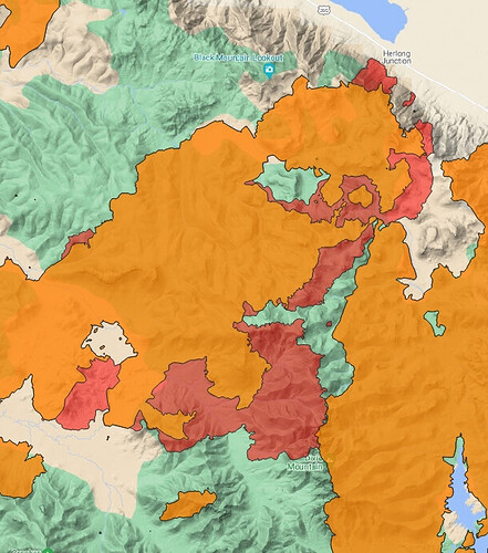
Fire spread 09/05 vs 09/06.
Orange = 09/05 perimeter.
Red = 09/06 new growth.

Old Station/44 area:

East end:

===============================================

KML files filtered from 20210907 data package found here:
https://ftp.wildfire.gov/public/incident_specific_data/calif_n/!CALFIRE/!2021_Incidents/CA-BTU-009205_Dixie/GIS/IncidentData/20210907/

For import into CalTopo, Google Earth, etc. Can’t vouch for how accurate they keep the data vs what’s really on the ground.

Completed Dozer Line. There are 3705 entries vs 3650 yesterday:

Completed All Type Of Line. There are 4854 entries vs 4775 yesterday:

Planned All Type Of Line. There are 148 entries vs 152 yesterday:

Here’s a new one. Entries tagged as ‘Contained Line’. 75 entries.

10 Likes

2 LATS, 163 and 160 enroute Dixie West from Fresno. Pretty sure they said west.

See a veg fire in the grass east shore of Meadow Mountains Reservoir @ 14:30:
http://www.alertwildfire.org/shastamodoc/index.html?camera=Axis-DyerMtn1&v=fd40740

There’s also some building column in the Lassen Park area:
http://www.alertwildfire.org/shastamodoc/index.html?camera=Axis-BunchGrassLookout2&v=fd40740

3 Likes

From Redding I can see pyroq on Dixie, Antelope, and a HUGE column on the Haypress. Pretty incredulous sight considering we’re not under red flag or other “unusual” weather conditions.

3 Likes